Download
1 / 25
250 likes | 785 Views
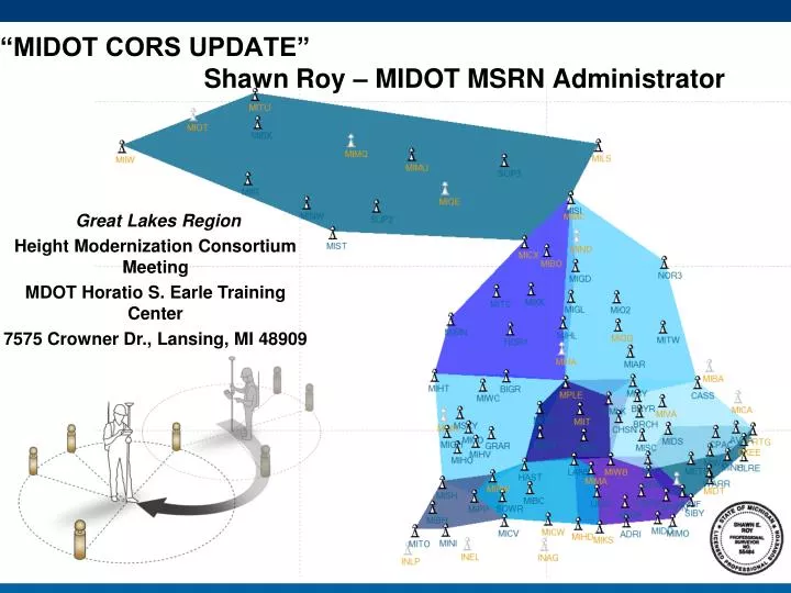
Great Lakes Region Height Modernization Consortium Meeting MDOT Horatio S. Earle Training Center 7575 Crowner Dr., Lansing, MI 48909. “MIDOT CORS UPDATE” Shawn Roy – MIDOT MSRN Administrator. MIDOT CORS Overview MIDOT MSRN - General Network Site Information.

E N D
Great Lakes Region Height Modernization Consortium Meeting MDOT Horatio S. Earle Training Center 7575 Crowner Dr., Lansing, MI 48909 “MIDOT CORS UPDATE” Shawn Roy – MIDOT MSRN Administrator
MIDOT CORS Overview MIDOT MSRN - General Network Site Information • Currently 95 Operating Sites in Michigan (99 TOTAL) • Sites with Operational Issues • Hudson (MIKS) – Issue with partner cooperation with IT Connection. • Decommissioned (Since 2000): • SUP1 – L'Anse Garage Removed for building Expansion (2001-06) relocated to Baraga and retitled MIBX • MIO1 – Mio Garage moved to new building (2002-11) - retitled MI02 • CASS – TSC closure required the removal of the GPS from the facility (2011-12-02). A new station is located at Cass City Public Middle Schools Property and has been retitled MICC • NOR2 – Gaylord TSC closure on 2011/01 required the removal of the GPS from the facility (2011-12-02). A new station is located at Gaylord TSC Property and has been retitled MIGD
General Network Information - Continued • Working on 4 New Sites • Albion (MIAB) – Site Located – Waiting for Documentation • Baldwin (MIBW) – Site Identified – In Testing for Interference with 911 radio system at Lake County Courthouse • Gladwin (MIGW) – Still Looking for Adequate Location (Spring ?) • Somewhere On Drummond Island (MIDI) • ListServ Email – Notification Email Server Added after State of Michigan GroupWise Change over. • http://www.mdotcors.org/ ..... News Advisories Link • To: listserv@listserv.michigan.gov Subject: (leave blank) Message body: subscribe MDOT-CORS-NOTIFICATIONS
MSRN Client Products • 1) NTRIP Caster for CMR+ at 136.181.134.9 on Port 10300 • *To access NEAREST_SITE you must send the server your GGA position to the server. • *We cannot generate a CMRx (CMR+ w/Glonass) type message, please option #4 • 2) NTRIP Caster for LB2 (Leica format) at 136.181.134.9 on Port 10400 • *To access R2K2_iMAX_LB2 you must send the server your GGA position to the server. • 3) NTRIP caster for GPS only data RTCM at 136.181.134.9 on Port 10200 • *To access NEAREST_SITE, R2K2_LITE_V3.0, and R2K2_FULL_V3.0 you must send the server your GGA position • to the server, and use RTCM Version 3.X. • *To access the other sites you must send the server your GGA position to the server, and use RTCM Version 2.3. • 4) NTRIP caster for GNSS data with RTCM 3.1 at 136.181.134.9 on Port 10700 • * PLEASE NOTE: That not all of the sites in the MSRN are available with Glonass, as they become available they will • appear in this list. Please do not call looking for site not listed. • *To access NEAREST_SITE, R2K2_LITE_V3.0, and R2K2_FULL_V3.0 you must send the server your GGA position to the server! • *^* It is recommended that you send your position at all times regardless of NTRIP product being used.*^*
USERS INFORMATION - NUMBER OF USERS PER TYPE Total Network users 830 Registered with MDOT 60% Survey oriented 11% GIS 29% AG
NGS Coordinate Change • MIDOT has not switched to NA2011 • Previously scheduled for January 2012 • Date pushed back to January 2013 • Michigan's CORS Range of Shift is 39mm to 3mm • No Historic Coordinates will Remain in MDOT Servers • Working on State-wide or Zone Transformations by creating RTK managed products
Create after overwhelming response from the Surveying Group Users wanted a way to work with NA2007 to finish existing projects for state and local agencies MIDOT Projects can have 3-4 year lifespan Current testing to solutions State-wide Local Zone (Michigan South 2113) Created with help from Henri Ayers from Leica Geosystems MSRN TRANSFORMATION
MIDOT network 40 receivers owned by County Partners Only 4 county sites are GG capable 55 receivers owned by MDOT ( 7 on the Shelf ) 24 Receivers are GG or GNSS capable MIDOT has purchased the necessary parts to upgrade all its own receivers Current Problems - MIDOT wants to upgrade to a GNSS system but funding for county owned site disappeared after some political changes inside the state. MIDOT want to include network product for GNSS system, but due to inconsistencies in the receiver types we are unable to run any network solutions. Possible take over of county sites by MIDOT? GNSS Antenna Upgrades – The possible development of a standard by NGS to upgrade antiquated Antenna technology? Possibly from AT504’s to AR25’s? GLONASS/GNSS UPDATES
Continuously Operating Reference Station (CORS) Typical Installations – Concrete Pillars with an Earlconic
Continuous Operating Reference Station (CORS) Typical Installations – Building Mounts
PARTNERSHIPS • Existing Partnerships • All the Michigan counties who purchased sites through Remonumentation funds • INCORS to Share Data (Network) • Shared Location with NOAA COOP water level gauges and MIDOT CORS, as with the case of Mackinaw city (MIMC) - Data from site is shared multi agency and used by MDOT, NOAA, NGS, and the Canadian Government. • Statewide Surveyors – helped with county sites that were in danger of being shut down due to county funding issues. (MILI, MIMO, MIDD) • Local business owners – MICO is hosted by a local Gas company chain • Potential Partnership • WisCORS to provide coverage along Michigan – Wisconsin border (Network and Single Baseline?) • Ohio CORS to provide coverage along Michigan – Ohio border (Network and Single Baseline?) • Possible Coast Guard sites? “ADMIRAL”
SERVERSCORS Diagram • MIDOT is currently working on migrating its services to a new location away from State managed systems. • This transition will be seamless for the users of the MSRN
SERVERS • MIDOT will keep it’s www.MDOTCOR.org site name, but plans to off the services of our RTN software provider. • The GOAL it to become more transparent and Real-time display of site outages for users of the MSRN. • The ability for users of MSRN to add accounts, and self manage accounts.
SERVERS • MIDOT will keep it’s www.MDOTCOR.org site name, but plans to off the services of our RTN software provider. • The hope it to become more transparent and Real-time display of site outages for users of the MSRN. • Also add user self managed accounts
FUTURE? • MIDOT management is working on a separate funding from its current system to maintain its system. • Changes in client products • Upgrade the MSRN to complete GNSS coverage rather than just GG only system compatibly. • Still be free to MSRN users!