1 / 0

Robert Billings, PE, PH, CFM Flood Mitigation Project Manager Charlotte-Mecklenburg Storm Water Services

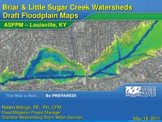
Consultation Coordination Officer Meeting. Mecklenburg County. Phase 1. Robert Billings, PE, PH, CFM Flood Mitigation Project Manager Charlotte-Mecklenburg Storm Water Services. September 19, 2012. Why are we here?. The Purpose of this meeting: To release updated flood hazard data

azana
Download Presentation

Robert Billings, PE, PH, CFM Flood Mitigation Project Manager Charlotte-Mecklenburg Storm Water Services

An Image/Link below is provided (as is) to download presentation Download Policy: Content on the Website is provided to you AS IS for your information and personal use and may not be sold / licensed / shared on other websites without getting consent from its author. Content is provided to you AS IS for your information and personal use only. Download presentation by click this link. While downloading, if for some reason you are not able to download a presentation, the publisher may have deleted the file from their server. During download, if you can't get a presentation, the file might be deleted by the publisher.

E N D

Presentation Transcript


  1. Consultation Coordination Officer Meeting Mecklenburg County Phase 1 Robert Billings, PE, PH, CFM Flood Mitigation Project Manager Charlotte-Mecklenburg Storm Water Services September 19, 2012
  2. Why are we here? The Purpose of this meeting: To release updated flood hazard data Explain the FEMA floodplain mapping process Discuss the Impact of New Maps Discuss Floodplain Management Standards Introductions Please introduce yourself….
  3. AGENDA NFIP Overview Mapping Overview Revision Results Impact on Insurance Rates Floodplain Management Standards Impact of New Maps Questions/Discussion
  4. Cooperating Technical Partner - CTP FEMA’s Cooperating Technical programs North Carolina is a Cooperating Technical State Mecklenburg County is a Cooperating Technical Partner
  5. Floodplain Statistics: 320 miles of streams 4000+ structures in the floodplain Average Precipitation: 40 inches per year Record Maximum Precipitation: 22 inches in 24 hours (1916 estimate) Probable Maximum Precipitation: About 33 inches
  6. Public Meetings Three Public Meetings were organized during September and October of 2010 The website address of the FMR application was published prior to the meetings The meetings began with a brief introduction and floodplain 101 presentation After the introduction, the attendees were asked to find a staff member or open laptop station to view the new floodplain data
  7. On-Line Survey Results Meeting attendees were asked to complete a brief online survey related to the mailers, meetings and FMR application One-on-one sessions with laptops and Storm Water Services staff were helpful to me. 60% Strongly Agree I would have preferred a traditional meeting with one formal presentation. 80% Disagree Not including the public meeting, I have looked at the draft floodplain maps online. 90% Yes
  8. PURPOSE OF NFIP To make flood insurance available Flood insurance is a requirement if there is a mortgage on the home To identify floodplains and areas at risk of flooding To provide standards, guidance, and a framework to help communities manage floodplains
  9. DEFINITIONS Digital Flood Insurance Rate Map (DFIRM) A digitally-produced FIRM, whether viewed in hardcopy or in digital form Flood Insurance Study (FIS) Details the examination, evaluation, and determination of flood hazard areas FIRMs are part of the FIS Base Flood Elevation (BFE) As shown on the FIRM, represents whole-foot elevations of the 1% annual chance flood Regulated to the nearest tenth of a foot; detailed information provided in the FIS
  10. DEFINITIONS Special Flood Hazard Area (SFHA) The 1% annual chance floodplain, where NFIP regulations must be enforced by the community as a condition of participation in the NFIP Floodway and Community Encroachment Area The portion of the SFHA, including the channel of a river or other watercourse, that must be reserved (free of development) in order to allow the discharge of the base flood without increasing the water-surface elevation more than 0.5 or 0.1 at any point along the stream
  11. Floodplain Regulations and the Flood Insurance Rate Map (FIRM) FEMA Floodplain Area Community Floodplain Area
  12. NC – CTS Panel Zone X Zone AE NGS Benchmark BFE Floodway (white hatched area) Stream Name Cross Section
  13. Floodplains Community (Future Conditions) Floodplain FEMA (Existing Conditions) Floodplain FEMA Floodway Community Encroachment Area
  14. BENEFITS FOR PARTICIPATING COMMUNITIES Allows flood insurance to be sold and renewed in the community Allows Federal agencies, such as the VA, FHA, HUD, EPA, and SBA to approve loans and grants for acquisition or construction within SFHAs Makes state and Federal disaster assistance available for flood-damaged structures Non-Participating Communities are not eligible for these benefits.
  15. MINIMUM FLOODPLAIN REGULATIONS UNDER THE NFIP Elevate all structures in SFHAs to at least the BFE published by FEMA (Mecklenburg County communities also include a Freeboard requirement) Protect all utility systems to at least the BFE published by FEMA Regulate encroachment/development in the floodways and community encroachment areas
  16. MAP MAINTENANCE CMSWS has completed producing DFIRMs and FIS Reports in the new digital statewide format for the Phase 1 mapping areas Smaller physical map revisions (PMRs) that include only the panels affected by the revised streams have replaced the large countywide revisions
  17. Phase 1 Mapping UPPER LITTLE SUGAR BRIAR LOWER LITTLE SUGAR BACK REEDY McKEE CALDWELL McALPINE CLEAR GOOSE McMULLEN CROOKED FOUR MILE TWELVE MILE SIX MILE CLEM
  18. POST-PRELIMINARY PROCESSING Preliminary panels are issued 2 notices in local newspaper 90-day Appeal/Protest Period Educational Meetings Resolution of Appeals and Protests The 6-month Compliance Period Letter of Final Determination from FEMA Map Adoption and Update of Flood Damage Prevention Ordinance
  19. POST-PRELIMINARY PROCESSING Final Preliminary panel was approved on September 6, 2012 90-Day Appeal/Protest Period: TBD; has been requested from FEMA Preliminary FIRM Meeting: September 25 and 26, 2012 Public Participation Meeting: TBD Opportunity for public to view, comment on, and ask questions about the new FIRMs
  20. POST-PRELIMINARY PROCESSING Local Responsibilities Provide public access to preliminary maps Advertise location(s) where maps can be viewed and publicize a Public Participation Meeting Review FIS and FIRMs for errors and missing information within the 90-day review period Forward appeals, and/or comments from the public and local officials to FEMA and copy State
  21. POST-PRELIMINARY PROCESSING Appeals An appeal is a formal objection to new or revised BFEs in the preliminary FIS Report or on the FIRM panels that is submitted during the 90-day appeal period Appeals are based on data that show proposed BFEs to be scientifically or technically incorrect
  22. POST-PRELIMINARY PROCESSING Appeals & Comments SUBMIT TO: Tim Trautman, PE Program Manager Mecklenburg County Flood Mitigation 700 N. Tryon Street Charlotte, NC 28202 (704) 336-7357 Brad Loar, Director Mitigation Division Federal Emergency Management Agency 3003 Chamblee Tucker Rd Atlanta, GA 30341 (770) 220-5200 The appeal period has not yet been determined
  23. Expanded Appeals Process FEMA’s Office of Chief Counsel recommended a broader interpretation of what can be appealed More consistent approach - changes in SFHA, zone, and regulatory floodway boundaries can have the same impact as a BFE/flood depth change Simplified Federal Register publications and online notices (no detailed stream names or flood depth information provided) All preliminary FIRMs and FIS reports and LOMR determination documents/attachments are available online, at http://charmeck.org/stormwater/StormWaterAgencies/Pages/FloodplainMapping.aspx
  24. The New Expanded Appeals Process (EAP)Effective December 1, 2011 Previously, appeals only applied to BFE determinations, but now it also includes the following: The addition or modification of any Special Flood Hazard Area (SFHA) boundary or zone designation The addition or modification of any regulatory floodway Applies to countywide studies, PMR studies, and LOMRs The EAP will apply to revised preliminary FIRMs that are the result of flood hazard changes unrelated to an appeal resolution The appeal period will apply to all revised preliminary AND preliminary FIRM panels
  25. POST-PRELIMINARY PROCESSINGEffective Date Changes on new flood maps (i.e. flood zones, boundaries and base flood elevations) will not affect flood insurance policies until the effective date of the FIRM This date will be established by FEMA through the LFD once submitted appeals and protests are evaluated and resolved
  26. POST-PRELIMINARY PROCESSING Local Responsibilities Communities must amend their Flood Damage Prevention Ordinances every time FEMA revises the DFIRM and/or FIS Report for that community CMSWS staff available for guidance through this process and for support at Public Hearings
  27. Reasons for Revising Floodplain Regulations Enable use of flood elevations (if higher) on preliminary maps to regulate new construction Add or revise certain definitions or requirements Clarify wording Correct typos Revise numbering / formatting Mandatory FEMA ordinance review
  28. CMSWS Recognition of Preliminary FIRM FEMA requires maps to be released as Preliminary for a period of about one year prior to the final approval by FEMA. The Preliminary maps may show increased flood elevations along some streams MCSWS would like to regulate construction of new buildings using the preliminary elevations, but only if the new elevations are higher than the flood elevations shown on the current flood maps.
  29. Regulate Where Floodplains are Increasing On Preliminary Maps
  30. Cannot Use Preliminary Maps Where Floodplains Decreasing
  31. Flood Insurance Impacts Flood Insurance Required if Have Mortgage and Building In FEMA Floodplain Rates Generally Based on Flood Depth Properties Newly Included in FEMA Floodplain Must Obtain Flood Insurance – Inexpensive Rates for 2 – Years ($129 - $400 /year) Grandfathering Provisions Flood Insurance May be Dropped if Building Removed From FEMA Floodplain
  32. POST-PRELIMINARY PROCESSING(existing policy) Grandfathering Structures built before the new FIRMs become effective may be eligible to continue to be insured at the same rate as they were under the previous maps Requires continuous coverage OR documentation of construction date and Flood Zone/BFE at that date Structures permitted under current FIRMs have grandfathering rights as well
  33. FLOODPLAIN MANAGEMENT STANDARDS
  34. DEVELOPMENT Development means any man-made change to improved on unimproved real estate, including, but not limited to: Buildings or other structures Mining Dredging Filling Grading Paving Excavating or drilling operations Storage of equipment or materials
  35. FLOODPLAIN DEVELOPMENT PERMIT A Floodplain Development Permit shall be required in conformance with the provisions of this ordinance prior to the commencement of any development activities within Special Flood Hazard Areas
  36. NO IMPACT CERTIFICATION A no-impact certification is required for any proposed development in the floodway or community encroachment area. A professional engineer must conduct a study and certify that the proposed development will have no impact on flood elevations. Community can issue a Floodplain Development Permit only after receiving the engineer’s certification.
  37. IMPACT OF NEW MAPS
  38. IMPACT ON LOMCs Community receives Summary of Map Actions (SOMA) listing all LOMAs, LOMRs, and LOMR-Fs issued since last FIRM effective date
  39. IMPACT ON LOMCs SOMA shows how each LOMC was affected by the preliminary FIRM Possible Actions: Incorporated (if LOMC is map-able) Superseded (if flood hazard was restudied and ground elevation is below new BFE) Revalidated (if LOMC is unaffected by map revision but is too small to show on FIRM) Revalidation letters are sent to affected communities prior to the new FIRM effective date and will become effective the following day
  40. IMPACT ON DEVELOPMENT REQUIREMENTS When FEMA publishes new flood maps or new regulations are adopted, any existing compliant development is grandfathered based on the flood maps and regulations that were in effect at the time of the building permit was issued, the date of construction, or the date of last substantial damage and/or substantial improvement – whichever is later
  41. USE OF PRELIMINARY DATA The use of Preliminary Data will be treated on a case by case process: Because Preliminary Data is the best available data, it may be used in some circumstances: Because Preliminary Data is not recognized by FEMA until it becomes Effective, it cannot be used in certain LOMC applications If communities wish to enforce more stringent data, they are encourage to adopt the Preliminary data
  42. Online Flood Map Review http://mapserver.mecklenburgcountync.gov/fmr/
  43. ADDITIONAL RESOURCES Charlotte - Mecklenburg County Storm Water Services - Flood Mitigation Program Tim Trautman, PE, CFM, Program Manager 704-336-7357 Tim.Trautman@mecklenburgcountync.gov Robert Billings, PE, PH, CFM, Project Manager 704-4532-0907 Robert.Billings@mecklenburgcountync.gov Bill Tingle, PG, CFM Flood Plain Administrator 704-336-3734 Bill.Tingle@mecklenburgcountync.gov Sharon Foote, Information & Education Coordinator, 704-336-3735 Sharon.Foote@mecklenburgcountync.gov
  44. Tim Trautman, PE, CFM Flood Mitigation Program Manager (704) 336-7357 Tim.Trautman@ MecklenburgCountyNC.gov Robert Billings, PE, PH, CFM Floodplain Mapping Project Manager (704) 432-0907 Robert.Billings@ MecklenburgCountyNC.gov Thank You
More Related