Download
1 / 1
10 likes | 237 Views
Wind Retrieval Techniques for Downward-Pointing, C onically-Scanning A irborne Doppler Radars. Stephen R. Guimond 1 , Gerald M. Heymsfield 2 , Stephen Frasier 3 and Lin Tian 4 1 NASA Goddard Space Flight Center and Oak Ridge Associated Universities, Greenbelt, MD

E N D
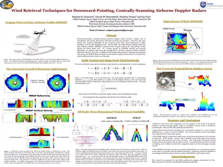
Wind Retrieval Techniques for Downward-Pointing, Conically-Scanning Airborne Doppler Radars Stephen R. Guimond1, Gerald M. Heymsfield2, Stephen Frasier3 and Lin Tian4 1 NASA Goddard Space Flight Center and Oak Ridge Associated Universities, Greenbelt, MD 2NASA Goddard Space Flight Center, Greenbelt, MD 3Microwave Remote Sensing Laboratory, Amherst, MA 4NASA Goddard Space Flight Center and Morgan State University, Greenbelt, MD Point of Contact: stephen.guimond@nasa.gov High-altitude IWRAP (HIWRAP) Imaging Wind and Rain Airborne Profiler (IWRAP) Abstract Downward-pointing, conically-scanning airborne Doppler radars provide a unique view of atmospheric and oceanic phenomena with their inverted cone geometry. However, that same unique view presents challenges for the retrieval of the three wind components at high-resolution over the full sampling swath. During GRIP, the High-altitude Imaging Wind and Rain Airborne Profiler (HIWRAP) sampled several tropical cyclones for long periods of time aboard the Global Hawk UAV. As a testing ground for HIWRAP analysis and retrieval algorithms, we analyzed data from the Imaging Wind and Rain Airborne Profiler (IWRAP) aboard the NOAA P-3 aircraft. In addition to providing solid ground for algorithm development and testing, the IWRAP dataset includes several intense tropical cyclones that are of interest for understanding hurricane inner-core dynamics. Above: The scan geometry of IWRAP flying aboard the NOAA P-3 aircraft (typical flight altitude of 2 – 5 km). The IWRAP instrument typically has four incidence angles, two frequencies per beam with range gates at 30 m and a scan rate of 60 RPM (along-track sampling every 100 – 150 m). Nadir Vertical and Along-Track Wind Retrievals Above: The scan geometry of HIWRAP aboard the NASA Global Hawk UAV (20 km flight altitude). The HIWRAP instrument has two incidence angles (30° and 40°), two frequencies per beam with current range gates at 150 m and a scan rate of 16 RPM (along-track sampling every 600 m). The fore and aft beam looks can be combined to yield vertical (w) and along-track (vt) wind components. Hot Towers in Tropical Storm Matthew (2010) The Concentric Eyewall of Hurricane Isabel (2003) where f is the fore beam, a is the aft beam and t are track-relative quantities with vhhydrometeor fallspeed, xf,a, yf,a, zf,aare radar positions, r is range, V is the Doppler velocity, u and v are cross-track and along-track velocity components, respectively and w is the Cartesian vertical velocity. The pulse volume positions are Category 5 Intensity (~ 920 hPa, 160 mph) where terms on the RHS are coordinate system rotation and aircraft attitude matrices. IWRAP Reflectivity Re-arranging the above equations and solving for the unknowns yields ZOOM ~1 km scale bands ~1 km scale bands IWRAP Vertical Velocity Off-Nadir Three-Dimensional Wind Retrieval Feasibility Above:Three-dimensional images of tropical storm Matthew from HIWRAP for the 230 uncalibrated reflectivity isosurface. Data collected on September 24, 2011 near 0600 UTC. IWRAP 0.5 km x 0.5 km x 0.03 km cells HIWRAP 2 km x 2 km x 0.25 km cells • Summary and Conclusions • Retrieval of the three wind components over the majority of the swath of downward-pointing, conically-scanning Doppler radars at acceptable accuracy levels is possible by combining the nadir and off-nadir methods presented here. • Final wind retrieval products will likely have a horizontal resolution of ~ 2 km x 2 km for HIWRAP and ~ 0.5 km x 0.5 km for IWRAP. The vertical resolution will be much higher and is dictated by the chosen gate spacing. • The IWRAP analysis of Hurricane Isabel (2003) reveals interesting features of a concentric eyewall cycle. These include: narrow, intense updrafts on the inner-edge of the primary eyewall with wide-spread descent in the core and ~ 1 km scale bands of moderate upward motion between the primary and secondary eyewall. It is possible that the primary eyewall is radiating waves radially outward with a stagnation radius near the developing secondary eyewall. • The HIWRAP instrument provides an essential high-altitude view of hurricanes and hot towers that is not possible with the IWRAP instrument. Preliminary data from HIWRAP is encouraging and future missions flown in tandem with IWRAP could be quite useful. ~1 km scale bands ~20 dB attenuation Above: The figures above depict the feasibility of three-dimensional wind retrievals on a grid cell scale. With two incidence angles for HIWRAP and four for IWRAP, many looks of the same grid cell are made by both radars. In order to unambiguously determine the horizontal wind vector, a look angle separation of 90° is required. Doviak et al. (1976), Davies-Jones (1979), Klimowski and Marwitz (1992) and others show that minimum azimuth diversities of 20° - 30° can produce wind vectors with acceptable accuracy. For HIWRAP/IWRAP, many of the looks in a defined grid cell are redundant. The contour plots above show the optimal (relative to 90°) azimuth diversity of the two radars as a function of cross-track distance and height. Horizontal wind vector retrievals are feasible over large portions of the conical swath with a data void region that grows with range near nadir. This azimuth diversity structure is approximately invariant in the along-track direction. Above: A collection of radar products from Hurricane Isabel (2003) on September 12, 2003. The Lower Fuselage (LF) scans at C band (top) show a concentric eyewall structure of Isabel at an extreme intensity of the storm. In the following 12 h, the pressure increased 15 hPa due to the destruction of the inner eyewall (note downdrafts in the IWRAP retrievals) as the outer eyewall contracted. Below the LF images are plots of IWRAP calibrated reflectivity and retrievals of the vertical velocity at nadir along the flight track. The pulse-pair correlation coefficient was used to filter noisy regions of the Doppler velocities. In addition, attenuation in the eyewall of Isabel (C band and Ku band) is also shown. The grid resolution for the IWRAP data is 200 m (along-track) x 30 m (vertical). Acknowledgements This research was supported by the NASA postdoctoral program administered by Oak Ridge Associated Universities and HIWRAP funding through GRIP.