Download
1 / 27
270 likes | 305 Views
Learn about Earth's structure, continental drift, seafloor spreading, plate tectonics, and plate boundaries. Discover the science behind earthquakes and tsunamis. Explore the fascinating geological history of our planet. Watch YouTube videos for an in-depth understanding.

E N D
Mexico quake-- magnitude at 7.0, and epicenter was in the western Pacific state of Michoacan. Its depth was about 40 miles • Indonesia-- earthquake off coast of Indonesia Wednesday, April 11 with magnitude of 8.6, sparking tsunami warnings
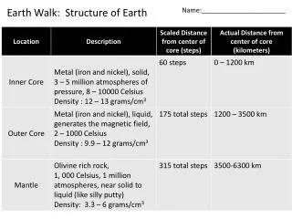
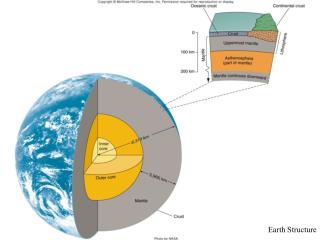
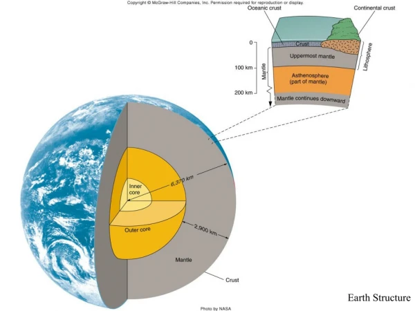
Lithosphere • Consists of continental, oceanic and upper part of mantle • Continents composed of granite-type rock, quartz and feldspar minerals, density+2.8g/cm3 • Oceanic crust formed of basalt; basalt rich in iron/magnesium minerals, density+3.0 g/cm3 • Lithosphere is rigid layer of crust and mantle overlying partially-molten asthenosphere
Why Continents Higher and Ocean Floor Lower • Isostacy—Principle that less dense continental crust sits higher on the mantle while denser oceanic crust sits lower • http://www.youtube.com/watch?v=G9rN7qhUQZg&feature=player_detailpage
Continental Drift Evidence • Geographic fit of continents • Fossils • Mountains • Glaciation • Researchers noted geographic fit of continents • e.g. Africa and S. America • Atlantic formed by separation of Africa from S. America • Seuss, 1885, proposed super continent by studying fossils, rocks, mountains • Wegener and Taylor, early 1900’s, proposed continental drift and Pangaea • Evidence supporting the idea that the continents had drifted.
Continental Drift Geographic Fit • Continents seem to fit together like pieces of a puzzle
Continental DriftFossils • Similar distribution of fossils such as the Mesosaurus
Continental DriftMountains • Mountain ranges match across oceans
Continental DriftGlaciation • Glacial ages and climate evidence
Objectionsto theContinental Drift Model • Wegener did not provide a plausible mechanism to explain how the continents could have drifted.
Seafloor Spreading • Continental drift reexamined in 1960’s with new information • New theory developed – Seafloor spreading • Supporting evidence for seafloor spreading • World seismicity • Volcanism • Age of seafloor • Paleomagnetism • Heat flow • Theory combining continental drift and seafloor spreading termed “Plate Tectonics”
Seafloor Spreading • New sea floor created at the mid-ocean ridge and destroyed in deep ocean trenches
Evidence for Seafloor SpreadingWorld Seismicity • Earthquake distribution matches plate boundaries
Evidence for Seafloor SpreadingVolcanism • Volcanoes match some plate boundaries; some are hot spots
Evidence for Seafloor SpreadingAge of Seafloor • Youngest sea floor is at mid-ocean ridge • Oldest sea floor away from mid-ocean ridge
Evidence for Seafloor SpreadingPaleomagnetism • When rocks cool at the Earth’s surface, they record Earth’s magnetic field (normal or reverse polarity) • Earth has a magnetic field - Probably caused by rotation of solid inner core in liquid outer core (both mostly Fe)
Evidence for Seafloor SpreadingPaleomagnetism • Paleomagnetic studies indicate alternating stripes of normal and reverse polarity at the mid-ocean ridge.
Seafloor SpreadingHeat Flow • In 1960, convection currents were proposed as driving force to move continents
Theory of Plate Tectonics • John Tuzo Wilson combined ideas of continental drift and seafloor spreading into “Plate Tectonics”
Principles of Plate Tectonics • Earth’s outermost layer composed of thin rigid plates moving horizontally • Plates interact with each other along their edges (plate boundaries) • Plate boundaries have a high degree of tectonic activity • mountain building • earthquakes • volcanoes
Plate BoundariesDivergent • Plates move away from each other • New crust is being formed
Divergent Plate BoundariesExamples Mid-Atlantic Ocean Ridge East African Rift
Plate BoundariesConvergent Three Types: • Ocean-continent • Ocean-ocean • Plates are moving toward each other • Crust is being destroyed • Continent-continent
Convergent Plate BoundariesExamples Mount Fuji, Japan Mount Lassen, California Andes, South America
Plate BoundariesTransform xxxxxxxxxxxxxxxxxxx • Plates slide past one another • Crust is neither created nor destroyed
Transform Plate BoundariesExamples Calexico, California San Andreas Fault Carrizo Plains, Central California