Download
1 / 15
150 likes | 371 Views
SLIP Enabler. “Seizing the opportunities”. 13/02/08. Chris Tweedie – Senior Geospatial Specialist WALIS Conference March, 2008. Agenda. What is SLIP enabler Seizing the opportunities What is possible? Business opportunities Future development of SLIP. SLIP is …. SLIP Enabler ….

E N D
SLIP Enabler “Seizing the opportunities” 13/02/08 Chris Tweedie – Senior Geospatial Specialist WALIS Conference March, 2008
Agenda • What is SLIP enabler • Seizing the opportunities • What is possible? • Business opportunities • Future development of SLIP
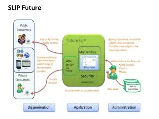
SLIP is …. SLIP Enabler …. Provides the foundation on which all SLIP initiatives operate, allowing land information to be shared the program of initiatives connecting WA Government spatial information Definitions
PaymentServices PortalServices System MgtServices Agency DisseminationServices Spatial DataServices SecurityServices OGC Web Services SLIP Enabler Services Web BrowserUsers GIS Application Users Business Solution Application Users SLIP-Enabler Service Users www.landgate.wa.gov.au Authentication & Authorisation Services WA Atlas(Map Viewer) Interragator+(Catalogue) User & InformationServices Data DownloadServices UserServices SLIP-Enabler /ows /waatlas /interragatorplus /slip /datadownload CoreServices VPN overInternet SLIP-Enabler Middleware Spatial Data Providers Virtual Agency Landgate DPI DIA DAFWA DEC FESA DoW DOIR MRWA Western PTA WC LGA SWDC Power Node
Current usage • > 1000 registered users • 500,000 hits per month • 80% Web Mapping Services • 60% Vector based • 40% Imagery • 20% Web Feature Services • Cadastre
Datasets Aboriginal Communities Cultural landscape Heritage Council Sites – WA Cadastre Cadastre Lodged Native Title (NNTT) Native Title (Fed Court) Townsites Localities Districts Native Title (Determination) Native Title (ILUA) Metropolitan Region Scheme – Zones and Reserves Metropolitan Region Scheme – Water Catchment Reservation Metropolitan Region Scheme – Redevelopment Scheme and Casino Peel Region Scheme Peel Region Scheme – Special Control Areas Overview Coastline Mapsheets Overview Roads Overview Rivers Overview Towns Coastline Roads Landing Grounds Railway Lines Misc. Transport Points Transport/Railway Stations Bridges / Tunnels WA Road Structures Control of Access on State Roads Geographic Names Points of Interest Dual Registered Stations Bush Fire Service Stations FESA Offices Spot Heights Contours Hydrology Wastewater Water Distribution Gravity Drainage Native Vegetation Extent Native Vegetation Extent by Type Pre-European Vegetation Intensive Land-use Zones NRM Regions Soil Landscape Zones Geomorphic Wetlands, Swan Coastal Plain Forest Disease Risk Areas Bush Forever Sites Bush Forever – Boundaries Acid Sulphate Soil Risk Map – Swan Coastal Plain Regolith of WA – 500m grid Regolith of WA – 1300m grid Geological Map of WA Interpreted Bedrock Geology of WA Clearing Regulations – Schedule One Areas Forest Blocks Minedex Mineral Drill Holes Mining Tenements Mineral Field Boundaries WA Petroleum Pipelines WA Petroleum Special Prospecting Authorities WA Petroleum Releases WA Petroleum Applications Swan River Trust Act, Management Areas DEC Managed Lands and Water DEC Region Boundaries DEC District Boundaries Local Government Authority Boundaries Ward Boundaries Bush Fire Service Districts Emergency Services Levy Boundary FESA Regions Fire and Rescue Services District Fire and Rescue Service Stations Ramsar Sites Public Drinking Water Source Areas NOAA Fire Affected Areas Apiary Sites Aboriginal Heritage Sites
Why SLIP Enabler? • Significant $$ savings across industry • Standards compliant • Temporal accuracy (best available) • Custodian retains ownership • Not a warehousing model • One-stop-shop for state govt. spatial data • Full metadata catalogue • Driven by WALIS community
Seizing the Opportunities Move beyond just map creation. The power has always been in data integration.
Feature Searching • Simple attribute based, searching • Zooming to feature <gml:featureMember> <sde:LGATE-008 fid="LGATE-008.23"> <gml:boundedBy> <gml:BoxsrsName="http://www.opengis.net/gml/srs/epsg.xml#4283"> <gml:coordinates decimal="." cs="," ts=" "> 116.11402135,-34.27349917 116.17878657,-34.22193127 </gml:coordinates> </gml:Box> </gml:boundedBy> <sde:GID></sde:GID> <sde:USAGE_CODE>152</sde:USAGE_CODE> <sde:NAME>MANJIMUP</sde:NAME> <sde:ROW_ID>23</sde:ROW_ID> </sde:LGATE-008> </gml:featureMember> <wfs:GetFeature service="WFS" version="1.0.0" outputFormat="GML2" ...> <wfs:QuerytypeName=“slip:LGATE-008"> <ogc:PropertyName>NAME</ogc:PropertyName> <ogc:Filter> <ogc:PropertyIsLikewildCard="*" singleChar="." escape="\"> <ogc:PropertyName>NAME</ogc:PropertyName> <ogc:Literal>M*</ogc:Literal> </ogc:PropertyIsLike> </ogc:Filter> </wfs:Query> </wfs:GetFeature> Where are all the LGA’s starting with “M”?
Notification service • Where change is critically important • Data frequently updated • Tenements or Tenure ideal candidates Change detected. Alerting subscribers WFS Alert me when anything in area X changes } TUES MON WED
Location Based Services • Portable devices converging with positioning • LBS built on SLIP information Addressing Tenure Points of Interest Locality/LGA Road network Public Transport Aerial Photography
Future roadmap • “Crowdsourcing” • KML service • Web Coverage Services • Catalogue Services Web • Virtual mosaic • Time series • CityGML • LandXML • High performance, tile cached WMS • Demographics
Issues Register • No standard compliance suite for clients consuming services • Idiosyncrasies vendor to vendor • Some features not accessible at all to the end user • Occasionally vendors do it completely backward • OGC support needs addressing in desktop GIS applications • Developers program to assist in best practices to improve SLIP access and other services
Contact Details Too many interesting topics, too little time... Come see a SLIP team member on the booth! or https://www.landgate.wa.gov.au/slip/ or chris.tweedie@landgate.wa.gov.au kylie.armstrong@landgate.wa.gov.au