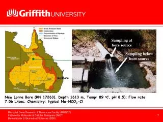
Download
1 / 13
310 likes | 1.05k Views
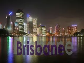
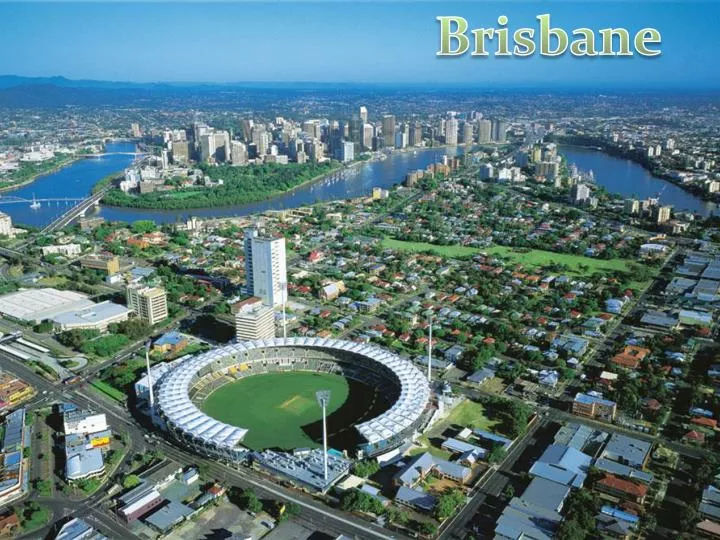
Brisbane. Overview. Brisbane is the 3 rd most populated city in Australia, with its metropolitan area of around 2 million people.

E N D
Overview • Brisbane is the 3rd most populated city in Australia, with its metropolitan area of around 2 million people. • Around 23km from Moreton Bay (which is situated at the mouth of the Brisbane river) is the Brisbane central business district and stands on the original settlement of Brisbane. • The metropolitan area extends in all directions along the floodplain of the Brisbane River valley between the bay and the Great Dividing Range • Brisbane was named after Sir Thomas Brisbane, the Governor of New South Wales from 1821 to 1825
Geographical Location & Features • Brisbane is in the southeast corner of Queensland, Australia. The greater Brisbane region is on the coastal plain east of the Great Dividing Range. Brisbane's metropolitan area stretches along the Moreton Bay floodplain from Caboolture in the north to Beenleigh in the south, and across to Ipswich in the south west. • The city of Brisbane is hilly.The urban area, including the central business district, are partially elevated. • The city is on a low-lying floodplain. Many suburban creeks criss-cross the city, increasing the risk of flooding. The city has suffered three major floods, in February 1893, January 1974, and January 2011. The 1974 Brisbane flood occurred partly as a result of "Cyclone Wanda". Heavy rain had fallen continuously for three weeks before the Australia Day weekend flood (26 – 27 January 1974).The flood damaged many parts of the city, the City Botanic gardens were inundated, leading to a new colony of mangroves forming in the City Reach of the Brisbane River
Transport options available • Brisbane has an extensive transportation network within the city, as well as connections to regional centres, interstate and to overseas destinations. The use of urban public transport is still only a small component of total passenger transport, the largest component being travel by private car. • Public transport is provided by bus, rail and ferry services. Bus services are operated by public and private operators whereas trains and ferries are operated by public agencies. • The City train urban rail network consists of 10 suburban lines and covers mostly the west, north and east sides of the city. It also provides the route for an Air train service under joint public/private control between the City and Brisbane Airport. Since 2000, Brisbane has been developing a network of bus ways, including the South East Bus way and the Inner Northern Bus way, to provide faster bus services. Trans Link operates an integrated ticketing system across the public transport network. • The Brisbane River has created a barrier to some road transport routes. In total there are ten road bridges, mostly concentrated in the inner city area. This has intensified the need for transport routes to focus on the inner city. There are also three railway bridges and two pedestrian bridges. The Eleanor Schonell Bridge (originally named, and still generally known as, The Green Bridge) between the University of Queensland and Dutton Park is for use by buses, pedestrians and cyclists. There are currently multiple tunnel and bridge projects underway as part of the Trans Apex plan. • An extensive network of pedestrian and cyclist pathways have been created along the banks of the Brisbane River to form a River walk network. • Brisbane's population growth placed strains on South East Queensland's transport system. The State Government and Brisbane City Council have responded with infrastructure plans and increased funding for transportation projects, such as the South East Queensland Infrastructure Plan and Program. Most of the focus has been placed on expanding current road infrastructure, particularly tunnels and bypasses, as well as improving the public transport system. • Brisbane Airport (IATA code: BNE) is the city's main airport, the third busiest in Australia after Sydney Airport and Melbourne Airport. It is located north-east of the city centre and provides domestic and international passenger services. In the 2008–2009 year, Brisbane Airport handled over 18.5 million passengers. The airport is serviced by the Brisbane Air train which provides a rail service from Brisbane's city centre to and from the airport. Archerfield Airport (in Brisbane's southern suburbs) acts as a general aviation airport.
Major Gateways for transport to your town/ city • • Major Gateways for transport to your town / city • The Port of Brisbane is on the lower reaches of the Brisbane River and on Fisherman's Island at the rivers mouth, and is the 3rd most important port in Australia for value of goods. Container freight, sugar, grain, coal and bulk liquids are the major exports. Most of the port facilities are less than three decades old and some are built on reclaimed mangroves and wetlands. • The Port is a part of the Australia Trade Coast, the country's fastest-growing economic development area. Geographically, Australia Trade Coast occupies a large swathe of land around the airport and port. Commercially, the area has attracted a mix of companies from throughout the Asia Pacific region.
History • Queensland was proclaimed a separate colony from New South Wales in 1859 and Brisbane was chosen as the capital. • The first European settlement in Queensland was a penal colony at Redcliffe, • Prior to European settlement, the Brisbane area was inhabited by the Turrbal and Jagera people, whose ancestors migrated to the region from across the Torres Strait. They knew the area as Mian-jin, meaning "place shaped as a spike". • The Moreton Bay area was initially explored by Matthew Flinders. On 17 July 1799, Flinders landed at what is now known as Woody Point, which he named "Red Cliff Point", after the red-coloured cliffs visible from the bay. In 1823, Thomas Brisbane (Governor of New South Wales at the time), instructed that a new northern penal settlement be developed, and an exploration party led by John Oxley further explored Moreton Bay. • Oxley discovered, named and explored the Brisbane River as far as Goodna, 20 kilometres upstream from the Brisbane central business district. Oxley recommended Red Cliff Point for the new colony, reporting that ships could land at any tide and easily get close to the shore.
Economy • Brisbane has the largest economy of any city between Sydney and Singapore, which includes cities like Jakarta, Darwin, Townsville & Cairns, and has seen consistent economic growth in recent years as a result of the resources boom. White-collar industries include information technology, financial services, higher education and public sector administration generally concentrated in and around the central business district and recently established office areas in the inner suburbs. • Blue-collar industries, including petroleum refining, stevedoring, paper milling, metalworking and QR railway workshops, tend to be located on the lower reaches of the Brisbane River and in new industrial zones on the urban fringe. Tourism is an important part of the Brisbane economy, both in its own right and as a gateway to other areas of Queensland. • Since the late 1990s and early 2000s, the Queensland State Government has been developing technology and science industries in Queensland as a whole, and Brisbane in particular, as part of its "Smart State" initiative. The government has invested in several biotechnology and research facilities at several universities in Brisbane. The Institute for Molecular Bioscience at the University of Queensland (UQ) Saint Lucia Campus is a large CSIRO and Queensland state government initiative for research and innovation that is currently being emulated at the Queensland University of Technology (QUT) Campus at Kelvin Grove with the establishment of the Institute of Health and Biomedical Innovation (IHBI). • Brisbane is one of the major business hubs in Australia. Most major Australian companies, as well as numerous international companies, have contact offices in Brisbane, while numerous electronics businesses have distribution hubs in and around the city. DHL Global's Oceanic distribution warehouse is located in Brisbane, as is Asia Pacific Aerospace's headquarters. Home grown major companies include Suncorp-Metway Limited, Flight Centre, Sunsuper, Orrcon, Credit Union Australia, Boeing Australia, Donut King, Wotif.com, WebCentral, PIPE Networks, Krome Studios, NetBox Blue, Mincom Limited, TechnologyOne and Virgin Blue. • Brisbane has the fourth highest median household income of the Australian capital cities at AUD 57,772.
Local customs • Brisbane has hosted many large cultural and sporting events including the 1982 Commonwealth Games, World Expo '88 and the final Goodwill Games in 2001. It was also rated the 16th most liveable city in the world in 2009 by The Economist. • Brisbane has a growing live music scene, both popular and classical. The Queensland Performing Arts Centre (QPAC), which is located at South Bank, consists of the Lyric Theatre, a Concert Hall, Cremorne Theatre and the Playhouse Theatre. The Queensland Ballet, Opera Queensland, Queensland Theatre Company and other performance art groups stage performances in the different venues. It is also the major performing venue for The Queensland Orchestra, Brisbane's only professional symphony orchestra and Queensland's largest performing arts company. The Queensland Conservatorium, in which professional companies and Conservatorium students also stage performances, is located within the South Bank Parklands.
Climate • Brisbane has a humid subtropical climate (Köppen climate classification Cfa) with warm to hot and humid summers and dry, moderately warm winters. From November to March, thunderstorms are common over Brisbane, with the more severe events accompanied by large damaging hail stones, torrential rain and destructive winds. • The city's highest recorded temperature was 43.2 °C on 26 January 1940. On 19 July 2007, Brisbane's temperature fell below the freezing point for the first time since records began, registering −0.1 °C at the airport. In 2009 Brisbane recorded its hottest winter day at 35.4 °C on August 24. • From 2001 until 2008, Brisbane and surrounding temperate areas had been experiencing the most severe drought in over a century, with dam levels dropping to 16.9% of their capacity on August 10, 2007. Residents were mandated by local laws to observe level 6 water restrictions on gardening and other outdoor water usage. Per capita water usage is below 140 litres per day, giving Brisbane one of the lowest per capita usages of water of any Western city in the world. A reversal of fortune in early 2008 has seen Brisbane's water storage climb to over 98% of maximum capacity. Water restrictions have been replaced with water conservation measures that aim at a target of 200 litres per day/per person, but consumption is rarely over 160 litres. • Dust storms in Brisbane are extremely rare; on 23 September 2009, however, a severe dust storm blanketed Brisbane, as well as other parts of eastern Australia. • Brisbane also lies in the Tropical Cyclone risk area. Although cyclones hitting Brisbane are rare, they have happened in the past. The last cyclone to affect Brisbane but not directly cross the city was Tropical Cyclone Hamish in March 2009, although the cyclone remained approx 350 km (220 mi) north of Brisbane but caused significant damage to beaches and caused the worst oil spill in Moreton Bay.
Health & Safety Advice • A large area of regional Queensland has been affected by floods, and even more recent cyclones, which has caused severe problems with availability of clean drinking water, lack of shelter.
Web links • http://www.sunloverholidays.com.au/accommodation/Brisbane-accommodation-apartments-T223.html?afid=SLGSEM&country=AU&mkwid=s4tchyUo2&pcrid=6409815311&gclid=CO2txYHzgqgCFcFrpAodoCEIrA • http://www.wotif.com/search/Advanced?viewType=weekends&page=1&country=AU&mapRequested=false®ion=1763&stlcmpid=SEM-3330-1127672659
Bibliography • http://ieconference.org/ie2008/wp-content/uploads/2008/03/tqld_south-bank_parklands.jpg • http://cache.virtualtourist.com/2769443-Brisbane_across_the_water-Brisbane.jpg • http://brisbaneblog.com.au/wp-content/uploads/2010/03/Brisbane-aerial-image.jpg • http://www.desertedtownsatoz.com/images/a-z-map.gif