Download
1 / 41
410 likes | 545 Views
Public Webpage. Review info for Upper Sand/Tollgate Creek and Westerly Creek. The two major creek systems in Aurora. Good way to monitor creek flows at multiple locations: compare current level to the flood stage . Another option for monitoring water levels via alert5.udfcd.org . Expo Park.

E N D
Review info for Upper Sand/Tollgate Creek and Westerly Creek. The two major creek systems in Aurora
Good way to monitor creek flows at multiple locations: compare current level to the flood stage
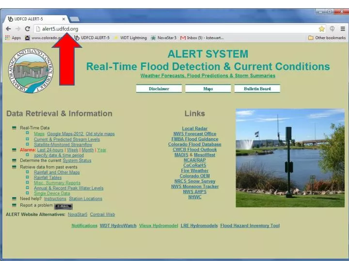
Another option for monitoring water levels via alert5.udfcd.org
Review the precipitation totals and use this info to determine if a response is required 1”+ in 30 minutes 2”+ in 1 hour
Standard F2P2 Messages F2P2 is short for UDFCD’s Flash Flood Prediction Program Serving the greater Denver metropolitan area since 1979in cooperation with NOAA’s National Weather Service
Standard MessagesWhy numbers are used? • The term “MESSAGE” and corresponding numbers (1, 2, 3 & 4) helps identify UDFCD’s private meteorologist as the information source. • Comparable NWS hydro products include: • Urban and Small Stream Flood Advisories • Flood Watch / Flash Flood Watch • Flood Warning / Flash Flood Warning • Plain language is used with F2P2 MESSAGES to indicate imminent vs. potential flood threats. • District local governments are familiar with this program and the practice of using MESSAGE Numbers 1-4.
Potential Flood Threat MESSAGE 1(Street Flood Potential) This message is used to inform key people that weather conditions are such that low impact nuisance flooding could develop later in the day—affecting streets, low-lying areas, normally dry gulches, small streams, and recreational trails along small drainage channels. Mud/debris/rockslides are the primary concern for the mountains and foothills, particularly for locations in and downstream of recent wildfire burn areas. Message 1 is the most common F2P2 message. In an average year, 30 to 40 days call for issuance of this message. When the threat of nuisance flooding is imminent, this message with include the sub-title“Low Impact Flooding” …more about this later. PMS refers to “Private Meteorological Service” contracted by UDFCD
Potential Flood Threat MESSAGE 1(Street Flood Potential)continued… The NWS may refer to this type of flooding as “low impact” flooding, which means that expected flooding will be localized and not wide-spread. This type of flooding is not generally considered life-threatening. However, fast moving water even at relatively shallow depths of 2-feet or less should always be considered dangerous, particularly along rivers, streams, and normally dry gulches or drainageways.
Potential Flood Threat MESSAGE 2(Flash Flood Watch) This message is to inform key people that Flash Flood Watch has been issued by NWS and that weather conditions are such that a life-threatening flash flood may occur later in the day. Significant stream flooding and property damage is possible should storms develop. PMS will add any additional information that is available.
Imminent Flood Threat MESSAGE 3 (Flash Flood Warning) This warning message will be issued to inform key people that a Flash Flood Warning has been issued by NWS or PMS feels that a life-threatening flash flood is imminent. Significant stream flooding and property damage is expected. PMS will add any additional information that is available. This warning message should be disseminated as quickly as possible.
Imminent Flood Threat LOW IMPACT FLOODING (LIF) An LIF subtitle will be used when PMS believes that a “nuisance” flooding rainstorm is imminent. It will normally be issued as a MESSAGE UPDATE to a prior potential flood threat message (MESSAGE 1 or 2). However, storms can develop unexpectedly that may necessitate an LIFwith the initial issuance of a MESSAGE 1. When a MESSAGE 3 is in effect, the LIF subtitle will not be used. If an approaching storm is expected to only cause nuisance flooding outside the warning area, plain language text in the MESSAGE 3 UPDATE will clearly indicate the nature of the threat. In summary, LIF’sare short lead notifications of imminent nuisance flooding threats where the risk to life and property is considered low. LIF’sshould be disseminated as quickly as possible.
Flood Threat Ended MESSAGE 4 (All Clear) This message cancels the flood threat status prior to its scheduled expiration. It is issued by PMS after consultation with NWS and other entities involved with direct PMS communications. NOTE: PMS will not issue a MESSAGE 4 when the current message is allowed to expire. The primary intent of this message is to notify jurisdictions of an early end to a flood threat.
UPDATE JULY 7, 2011
WEATHER RADAR • weather.com = The Weather Channel • thedenverchannel.org = channel 7 • weather.gov = National Weather Service • http://radar.weather.gov/radar.php?rid=FTG&product=N0R&overlay=11101111&loop=yes • Whatever you like UPDATE
UPDATE ZOOM IN TO STREET LEVEL
Preparing for the 2013 Storm Season • Go to the UDFCD website and practice surfing for information • Review info from yesterday’s storm • Identify a weather webpage • Learn to use the radar page • Look at the forecast info
2013 Expectations • Monitor information • Plan to respond if a message 2 or 3 is issued • Respond if necessary • 1” or more in 30 minutes • 2” or more in 1 hour • Safety is critical • Provide updates to SW supervisors & superintendent • Call for assistance • Photo flooding impacts