Download
1 / 1
10 likes | 120 Views
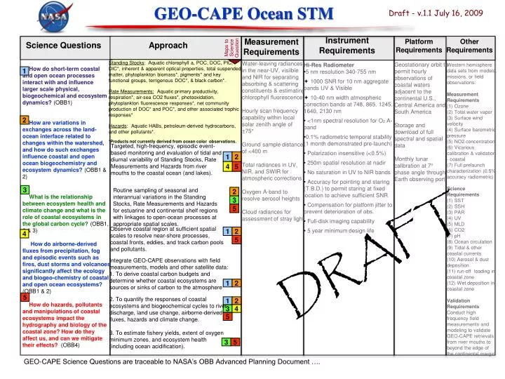
2. 4. 2. 4. 3. 1. 5. 1. 2. 5. 3. 5. 1. 5. 2. 5. 1. 2. 4. 2. 3. 5. 3. 1. GEO-CAPE Ocean STM. Draft - v.1.1 July 16, 2009. Instrument Requirements. Measurement Requirements. Platform Requirements. Other Requirements. Maps to Science Question. Science Questions.

E N D
2 4 2 4 3 1 5 1 2 5 3 5 1 5 2 5 1 2 4 2 3 5 3 1 GEO-CAPE Ocean STM Draft - v.1.1 July 16, 2009 Instrument Requirements Measurement Requirements Platform Requirements Other Requirements Maps to Science Question Science Questions Approach Standing Stocks: Aquatic chlorophyll a, POC, DOC, PIC, DIC*, inherent & apparent optical properties, total suspended matter, phytoplankton biomass*, pigments* and key functional groups, terrigenous DOC*, & black carbon*. Rate Measurements: Aquatic primary productivity, respiration*, air-sea CO2 fluxes*, photooxidation, phytoplankton fluorescence responses*, net community production of DOC* and POC*, and other associated trophic responses* Hazards: Aquatic HABs, petroleum-derived hydrocarbons, and other pollutants*. *Products not currently derived from ocean color observations. Water-leaving radiances in the near-UV, visilble and NIR for separating absorbing & scattering constituents & estimating chlorophyll fluorescence Hourly scan frequency capability within local solar zenith angle of ±75° Ground sample distance of <400 m Total radiances in UV, NIR, and SWIR for atmospheric corrections Oxygen A-band to resolve aerosol heights Cloud radiances for assessment of stray light Geostationary orbit to permit hourly observations of coastal waters adjacent to the continental U.S., Central America and South America Storage and download of full spectral and spatial data Monthly lunar calibration at 7° phase angle through Earth observing port • Hi-Res Radiometer • 5 nm resolution 340-755 nm • 1000 SNR for 10 nm aggregate bands UV & Visible • 10-40 nm width atmospheric correction bands at 748, 865, 1245, 1640, 2130 nm • <1nm spectral resolution for O2 A-band • 0.1% radiometric temporal stability (1 month demonstrated pre-launch) • Polarization insensitive (<0.5%) • 250m spatial resolution at nadir • No saturation in UV to NIR bands • Accuracy for pointing and staring (T.B.D.) to permit staring at fixed location to achieve sufficient SNR • Compensation for platform jitter to prevent deterioration of obs. • Full-disk imaging capability • 5 year minimum design life Western hemisphere data sets from models, missions, or field observations: Measurement Requirements (1) Ozone (2) Total water vapor (3) Surface wind velocity (4) Surface barometric pressure (5) NO2 concentration (6) Vicarious calibration & validation - coastal (7) Full prelaunch characterization (0.5% accuracy radiometric) Science Requirements (1) SST (2) SSH (3) PAR (4) UV (5) MLD (6) CO2 (7) pH (8) Ocean circulation (9) Tidal & other coastal currents (10) Aerosol & dust deposition (11) run-off loading in coastal zone (12) Wet deposition in coastal zone Validation Requirements Conduct high frequency field measurements and modeling to validate GEO-CAPE retrievals from river mouths to beyond the edge of the continental margin. How do short-term coastal and open ocean processes interact with and influence larger scale physical, biogeochemical and ecosystem dynamics? (OBB1) How are variations in exchanges across the land-ocean interface related to changes within the watershed, and how do such exchanges influence coastal and open ocean biogeochemistry and ecosystem dynamics? (OBB1 & 2) What is the relationship between ecosystem health and climate change and what is the role of coastal ecosystems in the global carbon cycle? (OBB1, 2 & 3) How do airborne-derived fluxes from precipitation, fog and episodic events such as fires, dust storms and volcanoes significantly affect the ecology and biogeo-chemistry of coastal and open ocean ecosystems? (OBB1 & 2) How do hazards, pollutants and manipulations of coastal ecosystems impact the hydrography and biology of the coastal zone? How do they affect us, and can we mitigate their effects? (OBB4) Targeted, high-frequency, episodic event-based monitoring and evaluation of tidal and diurnal variability of Standing Stocks, Rate Measurements and Hazards from river mouths to the coastal ocean (and lakes). Routine sampling of seasonal and interannual variations in the Standing Stocks, Rate Measurements and Hazards for estuarine and continental shelf regions with linkages to open-ocean processes at appropriate spatial scales. Observe coastal region at sufficient spatial scales to resolve near-shore processes, coastal fronts, eddies, and track carbon pools and pollutants. DRAFT Integrate GEO-CAPE observations with field measurements, models and other satellite data: 1. To derive coastal carbon budgets and determine whether coastal ecosystems are sources or sinks of carbon to the atmosphere 2. To quantify the responses of coastal ecosystems and biogeochemical cycles to river discharge, land use change, airborne-derived fluxes, hazards and climate change. 3. To estimate fishery yields, extent of oxygen minimum zones, and ecosystem health (including ocean acidification). GEO-CAPE Science Questions are traceable to NASA’s OBB Advanced Planning Document ….