Download

1 / 54
540 likes | 650 Views
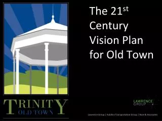
The 21 st Century Vision Plan for Old Town. Lawrence Group | Kubilins Transportation Group | Rose & Associates. Why This Plan?. Timing of Sewer Extension will encourage growth in coming years (2011) Easy Access from I-85 via interchange

E N D
The 21st Century Vision Plan for Old Town Lawrence Group | Kubilins Transportation Group | Rose & Associates
Why This Plan? • Timing of Sewer Extension will encourage growth in coming years (2011) • Easy Access from I-85 via interchange • Need for plan for municipal campus to leverage with state grants
Trinity is capable of deciding its own destiny. The question is…which path will you choose?
Study Area I-85
Priority Elements for Consideration • City Hall property (potential site for Veteran’s Memorial, City Hall, and park) • Bell Gazebo (Needs to stay on the old campus grounds) • New Gazebo (Easement is temporary from NC DOT – may need another location) • Braxton Craven School Gym was constructed by the community and includes a mural on the north side • Historic Properties (pre-1940’s)
What is Sustainable Development? A sustainable community is one that maintains the integrity of its natural resources over the long term, promotes a prosperous economy, and hosts a vibrant, equitable society. (ICLEI)
Keys for Successful Placemaking (Social Sustainability) • Housing – Housing – Housing • Connectivity + Circulation • Jobs (Daytime Population) • Public Space • Things to go Do • Things to go Buy
Primary Market Strategies (Economic Sustainability) • Create a CENTER (village center, Main St., downtown…???) • Which becomes your social & civic center of the community & commerce • Provide HOUSING • Various sizes, styles & pricing • For elderly, teachers, police & firemen • ECONOMIC DEVELOPMENT • Small Business Development (in center) • R&D/Lt. Industrial (gateways/Surrett)
Where are the best places? • Combine uses for synergy…Schools, Civic Buildings and Commerce… • Professional offices near City Hall…they all need to eat lunch…and go to Post Office… • High School football…stop for pizza/ice cream…go to the Library…
Comparisons of Key Intersections No surprise then, that Gas/Convenience stores are at Trinity & Finch Farm…but the Village Center is the BEST place for small local operators!
Site with Middle School Site with Business Park Middle School Site Options
South Main Development Calculations • 90,000 sf Commercial • Grocery Store, Pharmacy, Shops • 140,000 sf Flex/Light Industrial • 160 Homes/Townhomes
Transportation Network for the Village Center 35 mph ¼ Mile 5 Minute Walk 25 mph 35 mph
North Main Development Calculations • Alternative A • 40,000 sf Commercial/Mixed-Use • 220 Homes/Townhomes • Alternative B • 40,000 sf Commercial/Mixed-Use • 90 Homes/Townhomes • New Middle School
City Park – Key Recommendations • Passive Park with trails & picnic facilities • Veteran’s Memorial • Amphitheater with open lawn • City Hall location #1
Village Center – Key Recommedations • Mixed-use multi-story buildings – primarily 1-2 stories • Walkable streetscape with on-street parking, wide sidewalks, decorative lighting, landscaping, and furnishings • Buildings close together but small-scale with varying roof-lines and unique facades
Transportation Network for the Village Center 35 mph ¼ Mile 5 Minute Walk 25 mph 35 mph
Village Center Development Calculations • 80,000 sf Mixed-Use/Commercial • 50 Homes/Townhomes