Download
1 / 9
90 likes | 220 Views
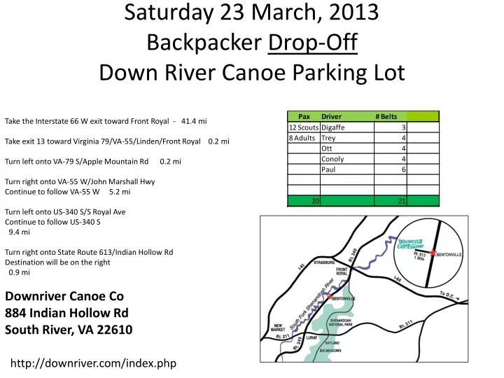
Saturday 23 March, 2013 Backpacker Drop-Off Down River Canoe Parking Lot. Take the Interstate 66 W exit toward Front Royal - 41.4 mi Take exit 13 toward Virginia 79/VA-55/Linden/Front Royal 0.2 mi Turn left onto VA-79 S/Apple Mountain Rd 0.2 mi

E N D
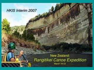
Saturday 23 March, 2013Backpacker Drop-OffDown River Canoe Parking Lot Take the Interstate 66 W exit toward Front Royal - 41.4 mi Take exit 13 toward Virginia 79/VA-55/Linden/Front Royal 0.2 mi Turn left onto VA-79 S/Apple Mountain Rd 0.2 mi Turn right onto VA-55 W/John Marshall Hwy Continue to follow VA-55 W 5.2 mi Turn left onto US-340 S/S Royal Ave Continue to follow US-340 S 9.4 mi Turn right onto State Route 613/Indian Hollow Rd Destination will be on the right 0.9 mi Downriver Canoe Co 884 Indian Hollow Rd South River, VA 22610 http://downriver.com/index.php
Monday 25 March, 2013 3:00pmBackpacker Pick-UpDown River Canoe Parking Lot Take the Interstate 66 W exit toward Front Royal - 41.4 mi Take exit 13 toward Virginia 79/VA-55/Linden/Front Royal 0.2 mi Turn left onto VA-79 S/Apple Mountain Rd 0.2 mi Turn right onto VA-55 W/John Marshall Hwy Continue to follow VA-55 W 5.2 mi Turn left onto US-340 S/S Royal Ave Continue to follow US-340 S 9.4 mi Turn right onto State Route 613/Indian Hollow Rd Destination will be on the right 0.9 mi Downriver Canoe Co 884 Indian Hollow Rd South River, VA 22610 http://downriver.com/index.php
Monday March 25, 2013Down River Canoe Parking Lot To:Camp Clark 1. Head south on State Route 613/Indian Hollow Rd toward State Route 628/Rocky Hollow Rd 0.9 mi 2. Turn left onto US-340 N/Stonewall Jackson Hwy Continue to follow US-340 N 11.2 mi 3. Turn right onto US-340 N/US-522 N/N Shenandoah Ave Continue to follow US-340 N/US-522 N 9.4 mi 4. Turn right onto US-340 N/Lord Fairfax Hwy/Teak Rd N Continue to follow US-340 N/Lord Fairfax Hwy 11.7 mi 5. Turn right onto W Main St/State Route 7 Bus 1.4 mi 6. Turn right onto VA-7 E/Harry Byrd Hwy 15.4 mi 7. Take the VA-287 S/VA-7 E exit toward Purcellville/Lovettsville 0.2 mi 8. Turn left onto VA-287 N/Berlin Turnpike 5.1 mi 9. Turn left onto Millstone Dr Destination will be on the right 38386 Millstone Dr Purcellville, VA 20132
Monday March 25, 2013Rocky Run Middle School ToCamp Clark 1. Take Virginia 28 N 4.4 mi 2. Take the exit on the left onto VA-267 W toward Leesburg Toll road 13.1 mi 3. Take exit 1A on the left to merge onto US-15 S/VA-7 W toward Leesburg/Warrenton 1.0 mi 4. Continue onto VA-7 W 3.9 mi 5. Take the VA-9 exit toward Hillsboro/Charles Town W VA 0.2 mi 6. Turn right onto VA-9 W/Charles Town Pike 5.1 mi 7. Turn right onto VA-287 N/Berlin Turnpike 1.9 mi 8. Turn left onto Millstone Dr Destination will be on the right 0.5 mi 38386 Millstone Dr Purcellville, VA 20132
Tuesday March 26, 2013Camp Clark ToHarper’s Ferry (John Brown Museum) Driving directions to John Brown Wax Museum 1. Head east on Millstone Dr toward Grange Dr 0.4 mi 2. Turn right onto VA-287 S/Berlin Turnpike 1.9 mi 3. Turn right onto VA-9 W/Charles Town Pike 4.7 mi 4. Slight right onto State Route 671/Harpers Ferry Rd 7.6 mi 5. Turn left onto US-340 S/Jefferson Pike Continue to follow US-340 S Entering West Virginia 1.8 mi 6. Turn right onto Shenandoah St 0.8 mi 7. Turn left onto High St Destination will be on the right 315 ft John Brown Wax Museum 168 High St Harpers Ferry, WV 25425
Tuesday March 26, 2013Camp Clark ToWhite’s Ferry (25mi meet point) 1. Head east on Millstone Dr toward Grange Dr 0.4 mi 2. Turn right onto VA-287 S/Berlin Turnpike 1.9 mi 3. Turn left onto VA-9 E/Charles Town Pike 5.3 mi 4. Turn left to merge onto VA-7 E 4.3 mi 5. Continue onto US-15 N 5.2 mi 6. Turn right onto State Route 655/Whites Ferry Rd Continue to follow Whites Ferry Rd 1.3 mi 7. Take the White's Ferry to Dickerson Entering Maryland 0.2 mi 8. Continue straight onto Whites Ferry Rd Destination will be on the left 423 ft Just after crossing the Bridge White's Ferry Inc 24801 Whites Ferry Rd Dickerson, MD 20842
Tuesday March 26, 2013Camp Clark ToWhite’s Ferry (25mile meet point) 1. Head east on Millstone Dr toward Grange Dr 0.4 mi 2. Turn right onto VA-287 S/Berlin Turnpike 1.9 mi 3. Turn left onto VA-9 E/Charles Town Pike 5.3 mi 4. Turn left to merge onto VA-7 E 4.3 mi 5. Continue onto US-15 N 5.2 mi 6. Turn right onto State Route 655/Whites Ferry Rd Continue to follow Whites Ferry Rd 1.3 mi 7. Take the White's Ferry to Dickerson Entering Maryland 0.2 mi 8. Continue straight onto Whites Ferry Rd Destination will be on the left 423 ft Just after crossing the Bridge White's Ferry Inc 24801 Whites Ferry Rd Dickerson, MD 20842
Tuesday March 26, 2013Camp Clark ToMarsden Tract(50 mile) 1. Head east on Millstone Dr toward Grange Dr 0.4 mi 2. Turn right onto VA-287 S/Berlin Turnpike 1.9 mi 3. Turn left onto VA-9 E/Charles Town Pike 5.3 mi 4. Turn left to merge onto VA-7 E 4.3 mi 5. Continue onto US-15 N 5.2 mi 6. Turn right onto State Route 655/Whites Ferry Rd Continue to follow Whites Ferry Rd 1.3 mi 7. Take the White's Ferry to Dickerson Entering Maryland 0.2 mi 8. Continue straight onto Whites Ferry Rd Destination will be on the left 423 ft Just after crossing the Bridge White's Ferry Inc 24801 Whites Ferry Rd Dickerson, MD 20842
Wednesday March 27, 2013 1:00pmRocky Run Middle School toCarderock Rest Area 1. Turn right onto US-50 E/Lee Jackson Memorial Hwy 3.6 mi 2. Merge onto I-66 E via the ramp on the left to Washington 6.8 mi 3. Take exit 64 B for Interstate 495 N toward Tysons Corner/Baltimore 0.5mi 4. Merge onto I-495 N Entering Maryland 6.5 mi 5. Take exit 41 for Clara Barton Parkway toward Carderock/Glen Echo 0.3 mi 6. Turn left onto Clara Barton Pkwy 0.9 mi 7. Take the exit toward I-495 0.1 mi 8. Keep left at the fork, follow signs for Carderock/Interstate 495 144 ft 9. Turn left onto Carderock 0.3 mi 10. Turn right to stay on Carderock 0.4 mi 11. Slight right to stay on Carderock Destination will be on the right 387 ft Carderock Recreation Area Chesapeake & Ohio Canal National Historic Park Potomac, MD 20854