Download
1 / 44
450 likes | 611 Views
JRP training 8 June 2012. The Mekong basin development planning process Ton Lennaerts CTA Basin Development Plan Programme. 1. The BDP Programme

E N D
JRP training 8 June 2012 The Mekong basin development planning processTon LennaertsCTA Basin Development Plan Programme 1
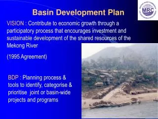
The BDP Programme • A participatory, multi-sector and integrated planning process that is led by the MRC Member Countries and implemented at the regional, national and sub-basin levels
The BDP Story • Provides an overview of basin development planning since the Second World War • Many planning reports were produced but little water infrastructure got built in the Mekong basin compared to other river basins • In industrialized countries, the best projects were completed before societal values shifted and major emphasis was placed on achieving environmental objectives • As a result, there are strong pressures today on the Mekong countries to adopt a different development path to growth than industrial countries have taken • This is a path largely untrodden and a challenge for the BDP Programme
The 1995 Mekong Agreement The Agreement is about cooperation on balancing basin development and protection. The BDP is a primary instrument for this cooperation Start of a new era of Mekong Cooperation: • Cooperate in all fields…but not limited to…hydropower, irrigation, fisheries… • Development of full potential of sustainable benefits for all Member Countries.....through formulation of a Basin Development Plan • Prevent harmful effects on the environment and the ecology • Enabled by water utilization procedures and monitoring systems e.g. Notification, Prior Consultation and Agreement of significant projects
‘Complex hydrology’ and limited investments in water management and infrastructure often correlates with widespread poverty around the world • Unique biodiversity and large fisheries on which millions of people in Mekong Basin depend • Much of the Mekong Basin remains among the poorest regions - malnutrition poses great challenges • Increasing demand for water resources development to reduce poverty and support an increasing population Storage Mekong development: meeting the needs, keeping the balance
DF UMD Definite Future Scenario 20Y w/o TMD 20Y w/o CMD 20Y w/o LMD 20Y w/o MD 20-Year Plan Scenario Development plans of LMB countries 7
Drivers of the LMB countries’ deveIopment plans • China • Created upstream storage • Investments in LMB (energy, agriculture, other) • Lao PDR • GDP growth through hydro-electricity exports (example: Panama) example) • (mitigation of climate change) • Cambodia • Generation and transmission of cheaper electricity • Expansion and intensification of agriculture • Viet Nam • Developed most of its hydropower and irrigated agriculture • Management of saline intrusion and flood damage
BDP1 (2001-2006) set up the process • Started 6 years (!) after the signing of the 1995 Agreement • It developed a participatory process, tools, strategic directions, and lists of non controversial projects
BDP2 (2007-2011) delivered the plan • Had to move beyond process: by 2007 water resources development was accelerating • Conducted a basin-wide cumulative impact assessment of the basin countries’ national plans, with and without consideration of climate change impacts (reported in 14 volumes) • Some characteristics of the process and examples of results are presented on the next slides
The assessment of basin-wide development scenarios • Balancing development and protection Responsible Growth
Agreeing on an acceptable balance • Using a basin-wide integrated assessment framework: • Basin-wide development scenarios assessed the cumulative environmental, social and economic impacts of national development plans and alternative perspectives • SEA of mainstream hydropower dams analyzed opportunities and risks • The MRC facilitated dialogue and negotiations on costs and benefits, and builds consensus on an acceptable balance between water resources development and protection • Three-year process; all stakeholders involved through meetings, surveys, workshops, conferences, forums, etc.
Scenarios considered Foreseeable Future and Longer Term Future Scenarios were assessed with and without consideration of climate change impacts
DF UMD BL VHD 20Y w/o TMD 20Y w/o CMD LTD 20Y w/o LMD 20Y w/o MD 20Y with all MD Main features of considered scenarios • Scenarios are defined by the level of land and water resources development in the Mekong Basin, including irrigation, hydropower, domestic and industrial water supply and significant flood management measures • Level of developments is derived from national plans, sector reviews and trends • Input data are reviewed and verified with the member countries 14
Assessment criteria Comprise 12 specific development objectives within economic, environmental and social spheres A total of 42 assessment indicators have been identified and assessed within the framework In addition, equity is evaluated Scope of assessment is NOT to endorse specific projects 15
Assessment approach Scoping and formulation Collection of input data Modelling of hydrological changes Assessment of transboundary environmental, social and economic impacts Evaluation and discussion of preferred scenarios Based on the concept of IWRM that holds the promise of reconciling goals of economic efficiency, social equity, and environmental sustainability Used transparent data sets, proven models and impact analytical tools and a multi-disciplinary expert team Stakeholder participation has been carried out along the whole process at sub-area, national and regional levels The scenarios were assessed on hydrological changes and results fed into the assessment of the transboundary economic, social and environmental impacts The results were discussed at national level and broader stakeholder Scenarios that are beneficial to all LMB countries and sustainable from a basin perspective, were considered as preferred scenarios 16
Integrated approach Each of the linkages will be taken into account in the assessment process Hydrological changes and physical impacts caused by interventions were assessed for their environmental and economic impacts and thence their social impacts 17
The tools MRC Decision Support Framework (DSF) SWAT • Knowledge Base • Planning and monitoring data such as: • hydrological records • physical data • socio-economic and environmental data • scenario description data • simulation model input data • simulation model results DSF User Interface and Tools Basin Simulation Modelling Package SWAT IQQM IQQM ISIS Impact Analysis Tools Reporting Tools Isis
The Tools (2) GIS for spatial integration and quantitative assessment Flooded area Wetlands
Flow changes in the Mekong mainstream Chiang Sean Luang Prabang Vientiane Nakhon Phanom Chiang Khan Mukdahan Pakse Strungteng Kratie Kampong Luong Prek Kdam Tan Chau Chau Doc 20
Changes in river bed and bank erosion • Cause: • Reduction of sediment entering to Mekong mainstream Chiang Saen Bedrock Alluvial Nong Khai • No major change in bedrock reaches • Sandbarsfrom Nong Kai to Pakse are readily erodible and river bed may begin to fall within next 20 years • Some sediment loss may occur immediately downstream of Kratie and changes in Delta will be visible in the long term, including coastal erosion Pakse Bedrock Strungteng Alluvial Delta 21
Changes in water quality In the longer term total agro-chemical use more or less triples compared to the present use. Water quality in the mainstream will deteriorate, but due to the increase in dry season flows and the river’s high self purifying capacity water quality will remain within standards Locally, mainly in the Delta downstream of Phnom Penh, problems may emerge
Reduction of valuable wetlands Incremental values are compared with Baseline scenario Unit:ha • Loss of valuable wetland due to reduced flooding particularly in Definite Future Scenario • The reduced area significant in Cambodia (mainly around Tonle Sap Lake ) followed by Lao and Thailand • Climate change will reverse the reduction of flooded areas and wetlands Inundated grasslands Marshes/seasonal wetlands Inundated forests 23 23
Impact on environment hotspots • 32environmental hotspots identified: Ramsar sites, biosphere reserves, protected areas, Important Bird Areas (IBA’s) • Major causes are • Definite Future • Change in flow and flood patterns • Foreseeable Future and Long term • Change in sedimentation, nutrient and water quality • Change in wetland habitats (deep pools, sandbars and rapids) and productivity • Blockage of migration route • Climate change • High impact by proposed developments in the 20-Year Plan Scenario with all 11 LMB mainstream dams 24
20-Year Plan Scenario without mainstream dams 20-Year Plan Scenario with 11 mainstream dams Low Low Medium Medium High High 25
Impacts on fish Luang Prabang Fish migration route Deep pool Pak Beng The scenario assessments estimate the loss of capture fisheries productivity SEA of mainstream dams identifies mitigation and enhancement measures Fish Expert Group discusses possible technologies and mitigation measures Xayaburi Pak Lai Pak Chom Sanakram Ban Kum Donsahong Strungteng Sambor
Impact on capture fisheries yield 27 • Capture fisheries yield is estimated based on habitats: river-floodplain, rain-fed and permanent water including reservoirs • Yield will either increase or decrease in rain-fed areas which depend on management practice while in reservoirs, yield will increase • Reduction will mainly happen in river-floodplain habitat due to many factors i.e. barriers, flow changes, habitat loss • Major losses in capture fisheries yield caused by the proposed two mainstream dams in Cambodia • These losses are particularly severe in Cambodia and Viet Nam Delta Thailand Cambodia Viet Nam Delta Lao PDR Viet Nam Highland
Social assessment: exposed vulnerable resource users (‘000 livelihoods at risk) 28
Net economic benefits • The net economic benefits in the various 20-Year Plan Scenarios are large and mainly derived from the development of hydropower • But there would be also significant benefits in irrigated agriculture, reservoir and rice filed fisheries and some in navigation • Main negative impacts are in loss of capture fisheries, wetland area production, biodiversity forest and recession rice • Lao PDR would gain most, mainly from hydropower production, but others would also benefit both as producers and consumers of electricity • Cambodia would benefit less than other countries, due to adverse impacts on capture fisheries 29
Comparison of economic NPV by sector and country (in ‘000 US$)
DF UMD BL 20Y w/o TMD 20Y w/o CMD 20Y w/o LMD 20Y w/o MD 20Y with all MD Some conclusions • There is considerable scope for further basin developmentthat can improve water, energy, and food security in the region • The natural dry season flow regime can be protected through the MRC Procedure on the Maintenance of the Flows on the Mainstream (PMFM) and and continue to meet the important and essential environmental and social needs 31
Transboundary benefits and costs • The assessment demonstrated the considerable interplay (nexus) between water, energy, food, environmental and climate security • With coordinated national planning, benefits can be created for all countries. • A few examples are given in the next slides
Example 1: Synergy between hydropower and irrigation development plans (20-year plan secnario) • Risk is small during the next 20 years that the redistributed water from the wet to the dry season by hydropower development is not sufficient to source the irrigation developments that are being planned • Transboundary benefit sharing in these two sectors amounts to $7,000 million • The natural dry season flow regime can be protected
Example 2: Trade-off beween hydropower development plans and capture fisheries 34 • Yield will either increase or decrease in rain-fed areas which depend on management practice while in reservoirs, yield will increase • Reduction will mainly happen in river-floodplain habitat due to many factors i.e. barriers, flow changes, habitat loss • The lower of the proposed eleven mainstream dams have the largest impact on LMB’s capture fisheries. • Regional capture fisheries net cost due to hydropower development amounts to $1,700 million in the 20-year plan scenario Thailand Cambodia Viet Nam Delta Lao PDR Viet Nam Highland
Example 3: Synergy between climate change and environmental values • In the 20-year and long-term scenarios, climate change reverses the reduction of flooding caused by ongoing and planned development • Climate change would benefit environmental values (by $240 million), increase recession rice production (by $450 million) but all of this will be offset by increased flood damages (by $650 million)
The IWRM-based Basin Development Strategy Responsible Growth
Basin Development Strategy (adopted January 2012) • Based on the assessment results of the basin-wide scenarios and the SEA of the proposed LMB mainstream dams, and the associated stakeholder consultations • For the first time since the 1995 Mekong Agreement, the countries have arrived at: • An understanding of each other’s water-related plans • discussed the likely transboundary impacts of their plans • Developed a shared understanding of the water-related development opportunities and risks • Negotiated the Basin Development Strategy
The Strategy describes • How the MRC member countries will share, utlize, manage and conserve the watre and related resources of the Mekong to achieve the goals of the 1995 Mekong Agreement • Development opportunities to improve water, food and energy security • 15 Strategic Priorities • For Basin Development • For Basin Management • To: • Address knowledge gaps and move identified development opportunities to implementation • Broaden and strengthen the basin planning framework • A Roadmap for implementation
Wide stakeholder engagement throughout the basin planning process
Implementation of the Strategy is underway at the regional and national level and will: • Reduce knowledge gaps (fisheries, sediments, ecosystems) • Address the adverse impacts of ongoing development • Develop a Mekong multi-sector mechanism for transboundary cost and benefit sharing • Develop environmental and socio-economic baselines • Bring regional and national planning ‘closer together’ • Broaden the current basin-wide scenarios to assess how regional benefits can be increased and regional costs reduced • Strengthen regional cooperation on basin planning and the implementation of the MRC Procedures
The future of te BDP Responsible Growth
The BDP will act as the instrument for impact analysis and consultation • Much of future basin development can and should be undertaken at the national level • The BDP will explore ways to achieve transboundary benefits and mitigate transboundary costs, through the adaptation and modification of national investments. • There are almost certainly transboundary opportunities, where two or more LMB countries could develop joint projects that provide substantive benefits that can be shared. • The only mandated instrument for identifying and promoting such opportunities is the BDP The future of BDP
The basin planning process is bringing transboundary cooperation and national process to the next higher level • Adapt national plans to mitigate regional costs • Adapt national plans to capture regional gains • Identify, negotiate & implement national investments that capture cooperative gains • Joint institutions • Joint project assessment & design • Joint investment • Joint ownership of assets • Communication & notification • Information sharing • Regional assessments Cooperation Continuum Dispute Integration Unilateral Action Collaboration Joint Action Coordination