Download
1 / 69
690 likes | 854 Views
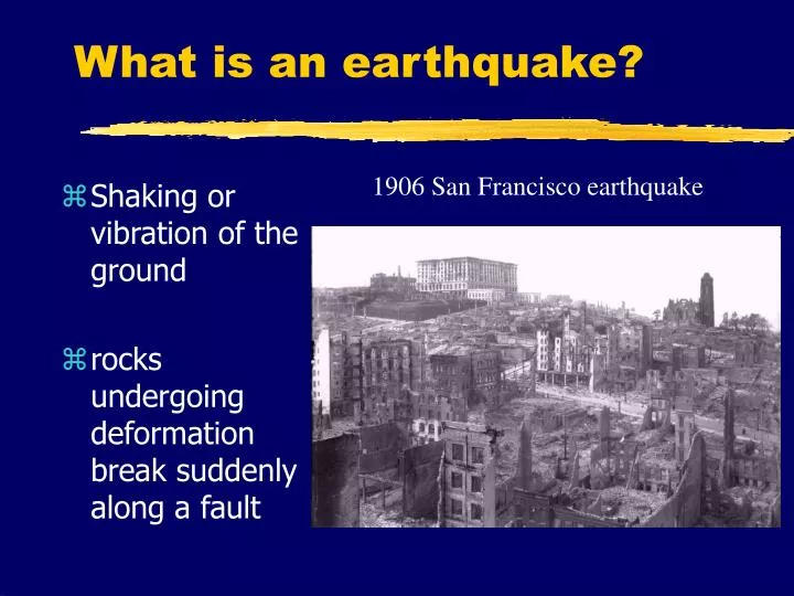
What is an earthquake?. Shaking or vibration of the ground rocks undergoing deformation break suddenly along a fault. 1906 San Francisco earthquake. Oblique view of the San Andreas fault and San Francisco. Where are earthquakes found?.

E N D
What is an earthquake? • Shaking or vibration of the ground • rocks undergoing deformation break suddenly along a fault 1906 San Francisco earthquake
Where are earthquakes found? • The Earth’s surface is composed of a number of mobile “tectonic plates” which are in constant motion • Most earthquakes are found at plate margins
Plate tectonics • The constant movement of the plates is referred to as plate tectonics • There are three main types of plate boundaries: • divergent • convergent • transform
Divergent margins • Here two tectonic plates are in the process of being created • Magma is injected into a crack, then cools and becomes new crust
An example of a wide, mature divergent margin • The middle of the Atlantic Ocean is a divergent margin which is being torn, or rifted, apart…the two plates are separating continuously at a rate of several cm/yr
An immature divergent plate margin • The Red Sea represents a young rift which is just beginning to separate Arabia from Africa… • Here, too, volcanism is evident, as a result of rifting
Volcanism in the Afar triangle • ‘Erta ‘Ale, a volcano slightly west of the Red Sea, represents the splitting apart and thinning of the African continent
Convergent margins I • Instead of two plates being created, they are being consumed… • Here an oceanic plate slides beneath a continental plate, since the former is denser • geologists refer to this process as subduction • Large, destructive earthquakes occur here
Convergent margins II • If two continental plates collide, they do not subduct, because they are too buoyant • Instead, intense compression with crustal shortening and thickening occur • Large, destructive earthquakes also are generated in this situation
Transform margins • The third type of plate margin is called a transform boundary • Here, plates are neither created nor destroyed… • they simply slide by one another
Where are the world’s earthquakes in terms of plate tectonics? • The great majority of earthquakes are located at plate margins • This where magmatism, friction, faulting, etc., are most intense • Earthquakes in plate interiors are comparatively rare
The Pacific Rim of Fire • This notorious zone is characterized by subduction zones • Earthquakes and volcanoes here are particularly violent • friction from subduction produces large destructive quakes
Faults associated with earthquakes • Faults are planes of weakness along which the Earth has been broken • Movements on a fault can be either slow (ductile deformation) or fast (brittle fracture) • When a fault behaves in a brittle manner and breaks, earthquakes are generated
Three types of dominantly vertical faults • A normal fault is the result of tensional forces (e.g., rifting) • Reverse and thrust faults are the result of horizontal compression
Faults whose movement is dominantly horizontal • These faults are termed strike-slip faults • They are a small-scale version of transform plate tectonic margins • They are termed left-lateral (sinistral) or right-lateral (dextral) according to their movement
Earthquake generation along a fault • The earthquake focus is its point of origin along a fault plane • Its epicenter is the vertical projection of the focus to the surface
Elastic rebound theory • Before fault rupture, rock deforms • after rupture, rocks return to their original shape… • ...maybe1 • 1Pallett Creek shows similar slip amounts after different periods of time; possibly not resetting to zero? See Sieh and Levay, 1998, p. 90
The Richter magnitude measures the maximum amplitude of ground shaking It is a logarithmic scale 1 Richter unit difference is x 10 for ground motion and x 33 for energy Globally, small earthquakes are more frequent than large: ~800,000/yr for events of magnitude 2.0-3.4 while an event of magnitude 8 occurs once every 5-10 years Richter magnitudes
Destructiveness of an earthquake • Earthquake magnitude • Distance to epicenter • Depth • Strength of building • Nature of soil or bedrock on which foundations are built • Other local conditions
A challenge • You yourself can calculate Richter magnitudes and epicenters from seismogram data. Go to: • http://vcourseware.sonoma.edu/VirtualEarthquake/ • Not only will you understand the science behind earthquake determinations, there are also material rewards...
The San Andreas fault • Along much of the west coast, the plate boundary is a transform margin
San Andreas fault • Although some people think San Francisco is “falling” into the Pacific Ocean, part of the city is actually already part of the Pacific plate • The San Andreas is a right-lateral strike-slip or transform fault
Right-lateral motion Photos from Shelton, 1966
Right-lateral motion Photo, diagram from Sieh and LeVay, 1998
The strike-slip nature of the San Andreas was not widely appreciated for up to 50 years after the 1906 San Francisco earthquake Yet rocks on either side of the fault are different The older the rocks, the greater the displacement Eocene-age rocks (37-58 Ma) show offsets up to 300 km Some history
San Francisco, 18 April 1906 • Magnitude 7.8, epicenter near San Francisco • $ 400 million US in damage • this is 1906 dollars; equivalent to hundreds of billions of dollars today • ~700 people reported killed • this is probably a 3-4 times underestimate; thus 2,000-3,000 dead, mostly in San Francisco
1906 - location and seismic trace Seismic trace of 1906 quake from a seismic station 15,000 miles away in Gottingen, Germany
1906 - comparative magnitude • This event is northern California’s most powerful event in recorded history
1906 - extent and slip The northernmost 430 km of the San Andreas ruptured, with horizontal slippage up to 8-9 meters
1906 - slip • This photograph shows a fence near Bolinas offset 2.5 meters
1906 - intensity and shaking • Maximum Mercalli values were VII to IX, which represent severe damage • Shaking lasted 45-60 seconds (for Loma Prieta 1989 and Northridge 1994, shaking lasted 5-10 s) • Shaking intensity correlated with geology, e.g., bedrock vs. landfill
1906 - some lessons learned • Big quakes can be followed by decades of seismic quiet • Quakes the size of the 1906 event appear to occur every several hundred (200?) years
1906 - some lessons learned (ctd.) • In the short term, San Francisco and environs are most at risk from an event of magnitude 6-7
1906 - some lessons not learned A topographic map of San Francisco from 1950... …and a 1980 version of the same map
Future quakes in the San Francisco Bay area Note the high probability of an earthquake of M > 6.6 occurring before 2030 in this area
Cascadia • In the Pacific Northwest, the tectonic regime is subduction-related, rather than transform as we have seen in California
Cascadia Here, there is evidence for very large earthquakes over the last several thousand years…the most recent is 300 years ago
Quebec • The St. Lawrence region has high levels of seismicity for a zone in the interior of a tectonic plate • This seismicity may be related to old, aborted rifts about 200 Ma ago Map from Lamontagne (1999)