Download
1 / 1
10 likes | 140 Views
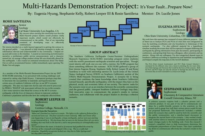
Multi-Hazards Demonstration Project: It’s Your Fault…Prepare Now!. ROSIE SANTILENA. Senior Geology Cal State University Los Angeles, CA. EUGENIA HYUNG. Sophomore Geology Ohio State University, Columbus, OH.

E N D
Multi-Hazards Demonstration Project: It’s Your Fault…Prepare Now! ROSIE SANTILENA Senior Geology Cal State University Los Angeles, CA EUGENIA HYUNG Sophomore Geology Ohio State University, Columbus, OH My concern when starting this internship was that the Multi-Hazards project leaders would produce vitally important results, which would not effectively be communicated to the public. Part of my internship consisted of developing ways to effectively communicate. My work here this summer has consisted of many different projects. One of them was to Analyze PGVs and PGAs of cities that were designated by Lucy by matching coordinates and city boundaries to shakemaps of the scenario earthquake. I’ve also collected material for a logarithmic timeline marking the events that will be expected to happen following the earthquake by getting information from past documents, participating in conferences, and getting help from my colleagues, other scientists and my mentor. Along with my colleagues, I’ve also categorized deposit types in Southern California according to liquefaction and landslide susceptibility and helped compile the map data in the ArcGIS database. Excerpt of Intro to ShakeOut webpage By: Eugenia Hyung, Stephanie Kelly, Robert Leeper III & Rosie Santilena Mentor: Dr. Lucile Jones We interns decided on a multi-layered approach to getting the science to the general public. I was pleased to help develop strategies to make our information relevant and understandable to the community. I helped set up and add events to the timeline. I created an interesting and informative narrative, a preliminary public service announcement, and a character named Joe, an average college student whose life was drastically altered by the earthquake. I also created an animated introduction about The Shake Out as well as an animated banner visible immediately upon opening The Shake Out web pages. GROUP ABSTRACT The Southern California Earthquake Center/Summer Undergraduate Research Experience (SCEC/SURE) internship program unites students with the world’s preeminent earthquake scientists and specialists. Though most interns still work one-on-one with a mentor, the SURE program has done something different this summer. SCEC/SURE gathered a group of four interns Eugenia Hyung, Stephanie Kelly, Robert Leeper III and Rosie Santilena to work with internship mentor Dr. Lucile Jones of the United States Geological Survey (USGS) on Southern California’s section of the USGS’s Multi-Hazards Demonstration Project. A scenario for is being created that combines the latest knowledge about Southern California’s natural hazards, specifically earthquakes, with the impact they have on the physical, social, and economic fabric of our society. The interns’ tasks for the scenario were to act as an interface between the scientific communities and the general public, interpret Southern California Geologic map data, find innovative ways to communicate the project’s results to various audiences, and collaborate with the project leaders to develop a cohesive scenario. The PGA (Peak Ground Acceleration) and PGV (Peak Ground Velocity) I calculated for the different cities were a factor in deciding the two main cities (now Palm Springs and Torrance) that would be the focus of the scenario. Both the PGA and PGV imply not only the amount of damage but also the types of structures that are most vulnerable to a certain wave length. As a member of the Multi-Hazards Demonstration Project for my 2007 SCEC/SURE internship, I was presented with exciting challenges and exposed to cutting edge Earth Science. I interpreted geologic map data to determine the susceptibility to landslides and liquefaction that certain areas of southern California will face in our M7.8 scenario earthquake. The data was input into ArcGis and will soon be processed by FEMA’s “HAZUS” risk assessment software for use in the scenario. I also wrote narratives that blend the science of the M7.8 scenario earthquake with the lives of characters chosen to represent southern California’s population and describe how the earthquake affected them. STEPHANIE KELLY Sophomore Chemistry & Comparative Literature Cornell University, Ithaca, NY ROBERT LEEPER III A cohesive scenario requires both a cohesive process and a coherent product. It was part of my job to communicate our ideas for a public-friendly scenario to the scientists on the project and to gauge how well their various pieces would fit into our proposed framework. This framework included a website about the scenario that could be used by both the scientific and the public communities, and a timeline-based document to integrate the myriad facets of the scenario. I also worked closely with another intern to research, consolidate and summarize the major changes made to the building code. From this research I created a simplified chart to help homeowners determine the earthquake preparedness of their houses. This chart symbolizes my desire to communicate effectively the scenario’s results to the public. Sophomore Geology Cerritos College, Norwalk, CA Excerpts from the Narratives: “Mike and I finished our lunch at 11:00am. The lights in the cafeteria flickered for a second and went out. The floor started to move violently. Mike and I knew what was happening; it was an earthquake, a large earthquake, and we were just starting to get hammered by it. We also knew that we were on the bottom floor of a 20-story building that was built in the late 60’s, and it was generating an unimaginably scary sound.” … “As I stared down the street, it looked as if someone had grabbed the street by the lines of the crosswalk and whipped it like a rug. This is a really bad situation. Hopefully my parents lucked out; they live in Palm Springs and I bet they didn’t even feel it.” Chart detailing building code changes for types of homes