Download
1 / 32
320 likes | 477 Views
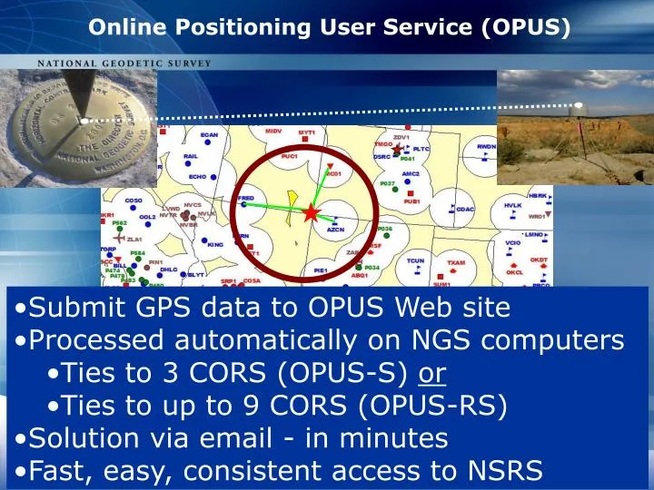
Online Positioning User Service (OPUS). Submit GPS data to OPUS Web site Processed automatically on NGS computers Ties to 3 CORS (OPUS-S) or Ties to up to 9 CORS (OPUS-RS) Solution via email - in minutes Fast, easy, consistent access to NSRS. combined. L1/L2 data 2-48hrs GPS (OPUS-S)

E N D
Online Positioning User Service (OPUS) • Submit GPS data to OPUS Web site • Processed automatically on NGS computers • Ties to 3 CORS (OPUS-S) or • Ties to up to 9 CORS (OPUS-RS) • Solution via email - in minutes • Fast, easy, consistent access to NSRS
L1/L2 data • 2-48hrs GPS (OPUS-S) • 15min-4hrs GPS (OPUS-RS) • Static GPS observations only • 30-second epochs processed • Correct vertical requires: • antenna type/phase model • mark-to-ARP vertical height OPUS Guidelines
e-mail GPS file antenna options antenna height OPUS-S (2 hr) OPUS-RS (15 min)
OPUS Options specify SPCS specify CORS
OPUS Options (cont) extended output XML output OPUS project user profile
Antenna Height • true vertical distance • measured in meters ARP MARK
GPS Antenna Calibration site for photos/diagrams: www.ngs.noaa.gov/ANTCAL/
CORS B How are OPUS-S Positions Computed? • NGS PAGES processing software • Ionospheric-free solution • Tropospheric scale height adjusted • Fixed ambiguities • Average of 3 unique CORS ties • ITRF & NAD83 coordinates/errors CORS A + CORS C
Is Your Solution Good? • > 90% observations used • > 50% ambiguities fixed • < 3 cm overall RMS • check ephemeris type • check antenna info • < 5 cm peak-to-peak errors …and which CORS were used? … resubmit later for better CORS scenario & ephemeris
NGS/IGS Precise Orbits • Precise (Final) • 14 days latency • 1 cm accuracy • updated weekly • Rapid • 1 days latency • 2 cm accuracy • updated daily • UltraRapid • 24 hrs observed / 24 hrs predicted • 5 cm / 10 cm accuracy • updated 4 times/day
OPUS – a good example of a bad solution SOFTWARE: page5 0601.10 master10.pl START: 2006/07/05 16:50:00 EPHEMERIS: igr13823.eph [rapid] STOP: 2006/07/05 19:08:00 NAV FILE: brdc1860.06n OBS USED: 638 / 2232 :29% ANT NAME: TPSLEGANT2 NONE # FIXED AMB: 10 / 18 :56% ARP HEIGHT: 1.524 OVERALL RMS: 0.027(m) REF FRAME: NAD83(CORS96)(EPOCH:2002.0000) ITRF00(EPOCH:2006.5089) X: -1639093.491(m) 2.480(m) -1639094.183(m) 2.480(m) Y: -5109885.356(m) 17.452(m) -5109883.985(m) 17.452(m) Z: 3439706.485(m) 7.775(m) 3439706.366(m) 7.775(m) LAT: 32 50 2.51844 2.899(m) 32 50 2.53444 2.899(m) E LON: 252 12 55.30565 2.965(m) 252 12 55.26422 2.965(m) W LON: 107 47 4.69435 2.965(m) 107 47 4.73578 2.965(m) EL HGT: 2211.550(m) 18.815(m) 2210.566(m) 18.815(m) ORTHO HGT: 2234.643(m) 18.815(m) [Geoid03 NAVD88]
OPUS – Extended Output • HTDP-transform CORS ITRF coordinates from published epoch to session midpoint • remote station ITRF solution from each CORS • G-files – vector components, standard deviations, & correlations for each vector • post-fit RMS & # observations per satellite/vector • solution covariance matrix-relates errors in each coordinate to every other coordinate • network accuracies - H & V • summary of NAD83 derivation • SPC feet values, if available for user’s state
OPUS-Rapid Static (OPUS-RS) • 15-minute sessions • ties to 3 – 9 CORS (< 250km) • uses RSGPS vs. PAGES software • P1/P2 code & L1/L2 phase observations • resolves all ambiguities with LAMBDA • similar to Real-Time Network computations • RSGPS solution modes: • network: solves ambiguities, tropo, iono • rover: tropo and ion interpolated to rover • ~10,000 lines of code
OPUS-RS Output NGS OPUS-RS SOLUTION REPORT USER: william.stone@noaa.gov DATE: October 29, 2007 RINEX FILE: 1207287x.07o TIME: 14:39:04 UTC SOFTWARE: rsgps 1.09 RS11.prl 1.12 START: 2007/10/14 23:27:15 EPHEMERIS: igr14490.eph [rapid] STOP: 2007/10/15 00:00:15 NAV FILE: brdc2870.07n OBS USED: 1962 / 2082 : 94% ANT NAME: ASH701975.01A QUALITY IND. 34.21/ 37.91 ARP HEIGHT: 0.0 NORMALIZED RMS: 0.307 REF FRAME: NAD_83(CORS96)(EPOCH:2002.0000) ITRF00 (EPOCH:2007.78627) LAT: 36 2 52.79767 0.008(m) 36 2 52.81498 0.008(m) E LON: 252 2 18.45532 0.013(m) 252 2 18.41156 0.013(m) W LON: 107 57 41.54468 0.013(m) 107 57 41.58844 0.013(m) EL HGT: 1974.304(m) 0.005(m) 1973.396(m) 0.005(m) ORTHO HGT: 1995.280(m) 0.026(m) [Geoid03 NAVD88] * • “#Fixed Ambiguities” replaced by “Quality Indicator” • average of W-ratio (separation between candidate sets of ambiguities) of last 3 epochs • reported as network mode / rover mode • look for values > 3 for confidence in solution
OPUS-RS Output NGS OPUS-RS SOLUTION REPORT USER: william.stone@noaa.gov DATE: October 29, 2007 RINEX FILE: 1207287x.07o TIME: 14:39:04 UTC SOFTWARE: rsgps 1.09 RS11.prl 1.12 START: 2007/10/14 23:27:15 EPHEMERIS: igr14490.eph [rapid] STOP: 2007/10/15 00:00:15 NAV FILE: brdc2870.07n OBS USED: 1962 / 2082 : 94% ANT NAME: ASH701975.01A QUALITY IND. 34.21/ 37.91 ARP HEIGHT: 0.0 NORMALIZED RMS: 0.307 REF FRAME: NAD_83(CORS96)(EPOCH:2002.0000) ITRF00 (EPOCH:2007.78627) LAT: 36 2 52.79767 0.008(m) 36 2 52.81498 0.008(m) E LON: 252 2 18.45532 0.013(m) 252 2 18.41156 0.013(m) W LON: 107 57 41.54468 0.013(m) 107 57 41.58844 0.013(m) EL HGT: 1974.304(m) 0.005(m) 1973.396(m) 0.005(m) ORTHO HGT: 1995.280(m) 0.026(m) [Geoid03 NAVD88] * • “Overall RMS” replaced by “Normalized RMS” • unitless quantity, “expected” = 1 • aka standard deviation of unit weight • if > 1, noisy data somewhere • typically <1, meaning noise less than expected
OPUS-RS Output NGS OPUS-RS SOLUTION REPORT USER: william.stone@noaa.gov DATE: October 29, 2007 RINEX FILE: 1207287x.07o TIME: 14:39:04 UTC SOFTWARE: rsgps 1.09 RS11.prl 1.12 START: 2007/10/14 23:27:15 EPHEMERIS: igr14490.eph [rapid] STOP: 2007/10/15 00:00:15 NAV FILE: brdc2870.07n OBS USED: 1962 / 2082 : 94% ANT NAME: ASH701975.01A QUALITY IND. 34.21/ 37.91 ARP HEIGHT: 0.0 NORMALIZED RMS: 0.307 REF FRAME: NAD_83(CORS96)(EPOCH:2002.0000) ITRF00 (EPOCH:2007.78627) LAT: 36 2 52.79767 0.008(m) 36 2 52.81498 0.008(m) E LON: 252 2 18.45532 0.013(m) 252 2 18.41156 0.013(m) W LON: 107 57 41.54468 0.013(m) 107 57 41.58844 0.013(m) EL HGT: 1974.304(m) 0.005(m) 1973.396(m) 0.005(m) ORTHO HGT: 1995.280(m) 0.026(m) [Geoid03 NAVD88] * * • Peak-to-Peak replaced by Est. Standard Deviations • approximately 95% confidence • derived from scatter of single baseline solutions • formal standard deviations (optimistic) available in Extended Output
Interpolative Dilution of Precision (IDOP) OPUS-RS accuracy is dictated by CORS geometry and distances IDOP - local CORS geometry relative to rover location [min = 1/sqrt(#CORS)] RMSD – CORS distances * Forthcoming paper in “GPS Solutions” – Accuracy Assessment of the NGS’s OPUS-RS Utility By C. Schwarz, R. Snay, & T. Soler
Estimated Vertical Standard Errors – f(IDOP & RMSD) 15-Minute OPUS-RS Sessions Estimated Horizontal Standard Errors – divide by 3.6
Expected OPUS-RS Standard Error Values in E or N Dimension: f (IDOP & Rover RMSD)
OPUS-Database (OPUS-DB) • streamlined method for users to publish their results • user registration –ID/password & validation process • submission review by user and NGS photo(s) description form GPS data observation log NGS website: OPUS-DB DATASHEET
NGS-calibrated GPS antenna • minimum 4 hour data span • minimum 70% observations used • minimum 70% fixed ambiguities • maximum 0.04m horizontal peak-to-peak • maximum 0.08m vertical peak-to-peak OPUS-DB Acceptance Criteria • OPUS-DB >>>>> • GPS on BMs for improved geoid model • improving coordinates for PLSS
OPUS-Projects Under Construction • project planning / monitoring • automated file management • review repeat measurements • reports sent to project managers • network adjustment • publish in NGS database
GIS & Mapping New Opportunities for Surveyors OPUS-Mapper • range solutions • single frequency observations • kinematic trajectories computed • accuracy appropriate for mapping/GIS • generate shapefiles Under Construction