Download
1 / 50
500 likes | 676 Views
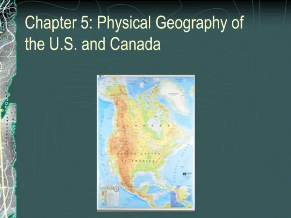
Social Studies: Ch. 1. U.S. Geography. States. 50 states in the U.S. 48 are contiguous Next to each other Which 2 states are separated?. States. Alaska and Hawaii are separated. Regions. States are grouped into regions An area where many of the features are similar 5 regions West

E N D
Social Studies: Ch. 1 U.S. Geography
States • 50 states in the U.S. • 48 are contiguous • Next to each other • Which 2 states are separated?
States • Alaska and Hawaii are separated
Regions • States are grouped into regions • An area where many of the features are similar • 5 regions • West • Southwest • Midwest • Southeast • Northeast
Regions • How do you think the regions got their names? • (Berson et al, 2007, pg. 16-17)
Continents • There are 7 continents • Large land masses • Asia • Africa • North America • South America • Antarctica • Europe • Australia
Continents • The United States is in North America • 3 largest countries in North America—U.S., Canada, Mexico • Which country has the largest population? • Which country has the most square miles? (Berson et. al, 2007, pg. 19)
Check up! • Mastery: What are the 5 regions of the United States? • Interpersonal: What other continent would you like to live on and why?
Check up! • Understanding: Find a statement in your notes that disproves this statement: There are 50 contiguous states in the U.S. • Self-Expressive: Finish this analogy: • (Example: up is to down as left is to right) • The United States is to North America as _______________ is to ______________.
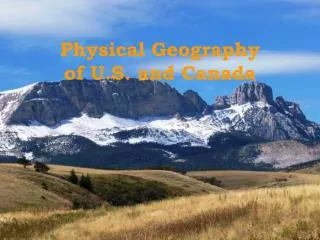
Landforms • Regions can be identified by landforms • Plains • Mountains • Plateaus • Hills • Valleys
Climate • Regions can be identified by climate • Weather that lasts over a long period of time in a certain place • Types of climate • Dry • Tropical • Moderate • Polar • How would you classify GA?
The Coastal Plain • How would you describe the Coastal Plain? (Berson et al, 2007, pg. 24)
Coastal Plain • The Coastal Plain is the flat, low area of land along the Atlantic Ocean. (Berson et al, 2007, pg. 24)
Appalachians • The Piedmont is the region of valleys and hills at the base of the Appalachian Mts. (Berson et al, 2007, pg. 24)
Appalachians • The Appalachian mountains are covered in trees • The oldest mountain range in the U.S. • Their peaks, or tops, were affected by erosion • Wearing away of Earth’s surface by wind, rain, and glaciers. • Have you ever been to the Appalachian Mts? • (Great Smoky, Blue Ridge, Catskill, White Mts.)
The Interior Plains • The center of the U.S., the land is flat and rolling. • The western part is called the Great Plains • Covered by prairies • Flat land with lots of grass a very few trees
Rocky Mountains • The largest and longest mountains in the U.S. • They stretch from Mexico to Canada • Between the Rockies and the mountains along the west coast is the Great Basin in Nevada • Basin—Low, bowl-shaped land with higher land surrounding it.
Great Basin (Berson et al, 2007, pg. 24)
Plateau • A plateau is a level area of land, but it is raised above the land around it (Berson et al, 2007, pg. 24)
Check up! • Mastery: Where is the Coastal Plain located? • Interpersonal: Suppose you are on a train through the Interior Plains. What would you see when you look out the window?
Check up! • Understanding: Compare and Contrast the Appalachian and the Rocky Mountains (think about age, size, and location). • Self-Expressive: Draw a symbol that would represent the word basin.
Bodies of Water • Inlets are areas where water extends into the land from a larger body of water. • Gulf—A LARGE inlet • Sound—a LONG inlet • Can you locate the Gulf of Mexico, Gulf of California, and Gulf of Alaska? (next slide or pg. 32) • Can you locate Puget Sound and Albermarle Sound? (next slide or pg. 32)
Bodies of Water (Berson et al, 2007, pg. 32)
Bodies of Water (Berson et al, 2007, pg. 32)
Lakes • Great Lakes—the 5 largest lakes in North America on the border of U.S. and Canada • Lake Superior • Lake Michigan • Lake Huron • Lake Erie • Lake Ontario • Most U.S. lakes consist of freshwater, except the Great Salt Lake in Utah.
Rivers • Rivers begin at a source and empty into a large body of water at its mouth. • Can you make a connection between the mouth of a river and the mouth on our face? • The Mississippi and its tributaries (other rivers that flow into it) create the largest river system in the U.S.
Rivers • People built cities near rivers because it made it easier to travel and transport goods. • Name 3 jobs that people have near the river. • What types of food can you find near a river?
Dividing the Rivers • The Continental Divide splits the river systems in the U.S. into two groups: • Runs north and south through the highest points of the Rocky Mts.
Check up! • Mastery: What was the cause for people building cities near rivers? • Interpersonal: If you lived near a river, what types of activities would you do most often?
Check up! • Understanding: Compare and contrast the Gulf of Mexico and Puget Sound (think about size/shape, Continental Divide location, and vocabulary similarities). • Self-Expressive: Create a pneumonic device that will help you remember the 5 Great Lakes. (ex. My Very Educated Mother Just Served Us Nachos helps remember the order of the planets.)
Climate • Climate is determined by the type of weather that occurs in a place over a long time • Places closer to the equator are warmer
Climate • The sun shines more directly on the places near the equator (Berson et al, 2007, pg. 37)
Climate • Can you explain why Montana is colder than Florida? • What else affects climate? • Distance from the ocean • Elevation (height of the land compared to sea level)
Climate • Weather in the contiguous states moves from west to east. • If mountains block rain clouds, which side of the mountains receives the most rain? East West
Vegetation • Natural vegetation—native plant life—grows easily in its home place. • Plant life is different in certain places based on temperature, soil, and MOST IMPORTANTLY precipitation.
Vegetation • 4 Vegetation Regions: • Forest • Grassland • Desert • Tundra In which region would you classify Georgia?
Vegetation • 4 Vegetation Regions: • Forest—lots of precipitation for trees to grow—Eastern US and parts of the West • Grassland—moderate precipitation—Great Plains and part of Central Plains • Desert—Arid, or dry, climate with low bushes and cactus • Tundra—cold and dry, no trees, covered often with snow
Check up! • Mastery: Name 3 factors that affect climate. • Interpersonal: Which vegetation region do you think a squirrel likes best? Why?
. Check up! • Understanding: Name two states that have opposite climates. Briefly describe their climates. (Think about places to which you have traveled.) • Self-Expressive: Draw a fictional creature that could live/survive in a tundra region.
Settling the Land • 300 million people in the U.S. • Why people settle/make a home in a certain place • Climate (good living conditions) • Soil (good for farming) • Water (good for fishing, transportation) • Landforms (good land for building homes)
Settling the Land • Air conditioning helps people live comfortably in desert climates. • What inventions help people live comfortably: in In the tundra (cold)? Near rivers?
Using the Land • ½ of U.S. land is used for farming • Coastal and Interior Plains • Fertile soil and enough water • Most mining done in the mountains • Cities take up large areas of land
Changing the Land • People modify, or change, the land to make it livable. • Modify water: • Dig wells • Build dams on rivers and streams • Irrigation—systems that move water • Use water • Dams create water reservoirs for drinking/cooking • Electricity
Changing the Land • Modify the Land • Cut down trees • Dig wells • Plow Land • Use the Land • Build homes on cleared land • Pump oil through wells • Plant crops on plowed land
Land Resources • Natural resources—something useful found in nature (renewable and non-renewable) • Renewable resources—can be made again and again • Soil, plants, water, light, wind • Non-renewable resources—cannot be made again or take thousands of years • Minerals, oil, gas
Non-renewable Resource • Did you know that oil is a resource used in everything that is plastic? Plastic cups Plastic toys Plastic water bottle Plastic bags Plastic containers Plastic chairs
Check Up! • Mastery: In your own words, give the meaning for the word modify. • Interpersonal: What do you feel are good ways to eliminate the waste of non-renewable resources?
Check Up! • Understanding: Identify some possibly causes for people choosing to settle land near water. • Self-Expressive: Discuss what would happen if air conditioners were never invented.
Resources Berson et al (2007). The United States: Making a new nation. Orlando: Harcourt.