Download
1 / 7
140 likes | 503 Views
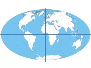
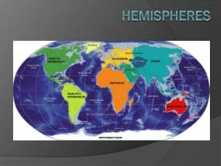
HEMISPHERES. The Earth can be divided into four parts or hemispheres: Northern Southern Eastern Western. Earth’s Hemispheres. LATITUDE AND LONGITUDE.

E N D
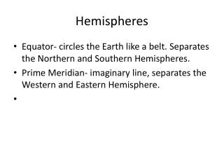
HEMISPHERES The Earth can be divided into four parts or hemispheres: Northern Southern Eastern Western
LATITUDE AND LONGITUDE • The Equator is a horizontal line that divides the earth into northern and southern hemispheres. It is an imaginary line that runs from east to west across globes and maps of the world. The equator is the starting line of latitude. • Latitude is the distance we measure for places that are north or south of the equator. • Latitude starts at the equator at a measurement of 0 degrees; • Latitude is measured north (N) or south (S) of the equator; • The maximum measurement for latitude is 90 degrees for both hemispheres.
LATITUDE • Since lines of latitude run from east to west in a horizontal pattern across maps and globes they are also called “parallel lines” . • There are seven major lines of latitude: North Pole 90 N ArcticCircle 66.5 N Tropic of Cancer 23.5 N Equator 0 degrees Tropic of Capricorn 23.5 S Antarctic Circle 66.5 S South Pole 90 S
LONGITUDE • Longitude is a vertical line that divides the earth into eastern and western hemispheres. It is an imaginary line that runs from north to south from the north pole to south pole across globes and maps of the world. The prime meridian is the starting line of longitude. • Longitude is the distance we measure for places that are east or west of prime meridian. • Longitude starts at the prime meridian at a measurement of 0 degrees; • Longitude is measured east (E) or west (W) of the prime meridian; • The maximum measurement for longitude is 180 degrees for both hemispheres.
LONGITUDE • The Prime Meridian runs from the north to south pole through Greenwich, England at 0 degrees. • The International Date Line runs from the north to south pole through the Pacific Ocean at 180 degrees. • Lines of longitude are also called “meridians”. The International Date Line
LATITUDE AND LONGITUDE GRIDS • When we use lines of latitude and longitude together they create a grid system over maps and globes of the Earth that we can use to locate places.