Download
1 / 41
410 likes | 524 Views
Parks Data Model Workshop YorkInfo Partnership. Steve Grisé Solution Architect, Vertex3 August 19, 2013. Agenda. Introductions and background – Deb Overview and Goals – Steve Individual Presentations – participants Process, next steps, participation - Steve. A Data Model is….

E N D
Parks Data Model WorkshopYorkInfo Partnership Steve Grisé Solution Architect, Vertex3 August 19, 2013
Agenda • Introductions and background – Deb • Overview and Goals – Steve • Individual Presentations – participants • Process, next steps, participation - Steve
A Data Model is… • A representation of the real world • A highly visible part of a computer system • An agreement between partners • A commitment to manage the data
A Good Data Model… • Meets the information needs • Information products • Maps • Reports • Derived Data • Applications and tools • Is simple and manageable • Complex things have simple data models • Then we simulate/visualize behaviour
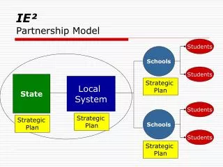
Data Model Purpose • Build Region-wide Parks Datasets • Consistent and reliable data about Parks • Support multiple needs • Mapping • Public Safety • Addressing • Must be Manageable and Practical • Share the data appropriately • A template for this type of project • YorkInfo Partnership collaboration
Data Model Context Recreation Addressing Parks Data Public Safety Public Facilities Emergency Response
Schedule • We are part way into a 30-day process • Initial Meeting • Workshops • Technical work • Final Presentations • Goals for sessions • Listen to specific needs • Balance the desirable vs. the possible • Score the information needs • Refine the data model content • Complete in September
Presentations • Short presentations from participating organizations • A chance to listen to other perspectives and begin understanding what the design might look like • Also a chance to listen to motivations, required benefits, and desired outcomes
Parks Data ModelTown of Aurora Cory MacNeil
Current Situation • Current Parks Data • What map layers and other data we manage? • Parks & Open Space Lots (Polygon) • Parks (Points) • Aurora Arboretum • Trails • Trails Points of Interest (Parking, washrooms, etc.) • What attributes are you maintaining? • Name, Rollnumber, Area, Park Amenity Fields (e.g. Baseball field, Parking, Shade structures, etc.) • What tools or applications do you have that use the data? • CityView for minor information
Projects and Activities • Goals • A parks dataset that will meet future needs. • Needs/burning issues • Incorporating photos of parks and their amenities. • Link electronic reservation system to web application • Applications • Interactive web application that will allow the public to find and obtain information on specific parks. It could show what amenities are available (sports fields, playground equipment, washrooms, parking, etc.) and display photos of the park. • Ongoing project work in this area • Some initial talks with the Director of Parks & Recreation to think about a possible interactive web application • Parks & Trails map that lists amenities for each park
Ideas for the Data Model • From your perspective what should region-wide parks data look like? • When zoomed in to a park? Identify amenities • When zoomed out to the entire Region? Generalized parks • What map layers, datasets, and fields should we have? • Parks polygons, points; Fields: Name, Location, Rollnumber, Amenity Fields • Are there specific applications and tools that you think are important for everyone to have access to?
Parks Data Model Shawn Condé – Town of Georgina
Current Situation • Town of Georgina does not have any municipal parks data in current GIS environment. • Information is in tabular format and is primarily used in hardcopy publications, was supplied to Region a few years ago. • Town currently purchasing and developing additional parklands (recently purchased additional 13 ha. on Lake Simcoe, new sub-divisions, etc.)
What constitutes a park? • Sibbald Point Provincial Park (225 ha.) and Duclos Provincial Nature Reserve (111 ha.) • Privately held park-lands i.e. Ducks Unlimited Bird Sanctuary, Arnold C. Mathews Nature Reserve (82 ha.), Salvation Army Lands (120 ha.), beaches, etc. • Regional Forests • Conservation Areas i.e. Willow Beach • Federal Wharfs and Piers i.e. Mossington Park, etc. • Road Ends/Road Allowances used as parks, especially on lake (i.e. usually, no civic address)
Parks Data ModelTownship of King Greg Czajko GIS Coordinator
Current Situation • Data and Applications • Layers • Parks_Assets – parks, benches, bleachers, play structure, swings etc • Schomberg Trails, King City Trails, Trail_Access • Attributes: • Minimal... name, type etc. • Use • Internal viewer (ArcGIS Explorer) • Mapping (ArcGIS Desktop)
Projects and Activities • Another short slide • Goals • Maintenance of data and Mapping products. • Needs/burning issues • None identified ATM. • Applications • None identified ATM. • Ongoing project work in this area • Mapping of King City Trails.
Ideas for the Data Model • From your perspective what should region-wide parks data look like? • When zoomed in to a park? • Activities at the park. Eg. Sport, swings, parketteetc • When zoomed out to the entire Region? • Just location, perhaps name. • What map layers, datasets, and fields should we have? • Discussion… extremely broad range of applications. • Are there specific applications and tools that you think are important for everyone to have access to? • Location and Function should suffice, Availability and Assets are useful in the long term.
Parks Data ModelTown of Newmarket Annaliese Vollick
Current Situation • Current Parks data at the Town of Newmarket • What map layers and other data are you managing? • PARKSAREAS (area) • PARKSFEATURES (area) • LANDMARKS (point)
What attributes are you maintaining? • PARKAREAS • PARKFEATURES
What tools or applications do you have that use the data? • Navigate Newmarket (external) • Landmark/Park Search • Park Features Search (ie – Ball Diamonds, Soccer fields) • Base Map • InfoGenerator (internal) • Landmark/Park Search • Park Features Search (ie – Ball Diamonds, Soccer fields) • Base Map • Customer Service (CRM) Software • Uses LANDMARKS layer as a look up option for customer service calls
What tools or applications do you have that use the data? (cont’d) • P.O.S.T. Manual (Parks Open Space and Trails) • Locations, inventory within • Asset Reporting • Areas, features, etc. • Parks and Cultural Features Map • Hard copy and pdf map available on www.newmarket.ca – numbered list of Parks/Cultural Features (Landmarks also shows Trails)
Projects and Activities • Goals • Park Addressing • Needs/burning issues • Park Addressing • Better extraction for asset management reporting • Applications • ?
Projects and Activities • Ongoing project work in this area • Adding attributes to track “Historic Names” and “Local Names” • Parks that have changed names and parks that are known by another name (Operations) • Better identification (within our layers) of Town owned vs. Town Maintained • Process for GIS maintenance of Park Features between our Recreation and Culture and Parks Department • Inventories of more park features using GPS and integration to existing
Projects and Activities • Ongoing project work in this area • Parks Addressing • Emergency response • General Public awareness • Challenges with Parks with multiple entrances (ie – Fairy Lake) • YRP to track incidents • Park Addresses will/should be identified in Town Address layer as well as Park Areas/Landmarks
Ideas for the Data Model • From your perspective what should region-wide parks data look like? • When zoomed in to a park? • Area • When zoomed out to the entire Region? • Point Feature/Symbol • What map layers, datasets, and fields should we have? • Park Boundaries/Points • Addresses
Ideas for the Data Model • Are there specific applications and tools that you think are important for everyone to have access to? • Using Common Park Names and Addressing • ?
Parks Data ModelTown of Whitchurch-Stouffville Simon Morris
Current Parks Data • One polygon Parks dataset and one polyline Trails (bikes and walking) dataset • Attributes - Name and Available Facilities (Playground, Picnic Area, Open Area, Washroom, Baseball Diamond, Soccer Field, Tennis Court, Basketball Court, Ball Hockey Court, Toboggan Hill, Outdoor Ice Rink, Splash Pad, Trails and Parking) • We will be providing this data through ArcGIS Online on new WS website in September
Projects and Activities • Currency and attribute accuracy is very important as the WS Parks data will soon be accessible to public • ArcGIS Online map / application • Conceptual Trails and Parks Map
Ideas for the Data Model • From your perspective what should region-wide parks data look like? • Park scale - Light green with poly symbology for rinks, diamonds, courts, splash pads etc • Region scale - Light green • Layers - Entry points for 911, Facilities (rinks, diamonds, courts, splash pads) Attributes - Facilities available in each park, built vs planned, park type (park, parkette etc), • Have trail system and parks synchronized to make a trail/park network across York Region
Process • Draft Model – 30 days • Project work – 60-90 days + • Final model - ~3-6 months Draft Model Projects Final Model
Next Steps • Coordinate follow up meetings • Technical work • Link to projects/activities in different orgs
Next Steps • What will it take to make this a working partnership?
Contact: • Steve Grisé • steve@vertex3.com • 226 444 0323