Download
1 / 26
260 likes | 410 Views
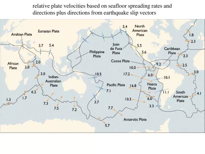
relative plate velocities based on seafloor spreading rates and directions plus directions from earthquake slip vectors. Ways to measure deformation. Very Long Baseline Interferometry VLBI. Triangulation network in Mexico. Satellite Laser Ranging. Laser-based total station surveying. Scale

E N D
relative plate velocities based on seafloor spreading rates and directions plus directions from earthquake slip vectors
Ways to measure deformation Very Long Baseline Interferometry VLBI Triangulation network in Mexico Satellite Laser Ranging Laser-based total station surveying
Scale 10 mm/yr Very Long Baseline Interferometry (VLBI) determinations of plate velocities HARTRAO
SLR velocities compared to NUVEL velocities from seafloor spreading and earthquake data
More ways to measure deformation • Types of GPS: • Hand-held: accuracy ~10-30 m instantaneous • Campaign mode: accuracy ~1-5 cm/yr • Continuous mode: accuracy ~1-3 mm/yr
More GPS • Problem, only possible to measure deformation at specific points) • Plate motions measured by GPS
Regional velocity field • No matter how measured, deformation measurements can be used to create a velocity field. Now what? SCEC Velocity model 3.0
Regional velocity field Make profiles to study fault slip rates • How do we know where to make profiles? • Largest recent earthquakes on previously unrecognized or under-appreciated faults! • Bourne et al., 1998
Microplates in western U.S. Measured displacements Colorado Plateau Remove subduction zone inter-seismic signal Stable Sierra Nevada block Seth Stein’s webpage McCaffrey et al., 2003
EURASIA ARABIA NUBIA SINAI Deformation in eastern Mediterranean Anatolia rotates as a rigid microplate, about pole near Sinai Aegean interpreted as diffuse extension, shown by steadily increasing rates Seth Stein’s website
Deformation in eastern Mediterranean But deformation can also be described by several microplates Nyst & Thatcher, 2004
Seafloor stations communicate with float with communicates with GPS satellites Seafloor Geodesy Attach stations to seafloor Example of subduction deformation on seafloor off Peru From: Gagnon et al., 2005
Aircraft: Shown here: AIRSAR Measures topography, ocean currents Synthetic Aperture RadarInterferomteryInSAR Satellites: Repeat pass Fly over once, repeat days-years later * Measures deformation and topography Space shuttle: Shown here: Shuttle Radar Topography Mission (SRTM) Measures topography, deformation with other missions Both from: JPL From: H. Zebker
moho crust upper mantle Seafloor spreading is a tape recorder of the geomagnetic field! The recorded reversal chronology Age, Ma The tape drive The recording head of the tape recorder
Ocean Ridge system Mid-Atlantic Ridge East Pacific Rise Modern view of ocean bathymetry derived from satellite altimetry. see EXPLORING THE OCEAN BASINS WITH SATELLITE ALTIMETER DATA Global Bathymetric Prediction for Ocean Modelling and Marine Geophysics
Global bathymetry Map shown in next slide
Ship tracks across the East Pacific Rise which obtained the magnetic anomalies shown in the next slide. The measurements were made in the 1960’s by the Columbia University research vessel Eltanin. 21 20 19
The famous Eltanin 19 profile The Eltanin 19 profile is among the most influential geophysical profiles ever published. It provided the “smoking gun” evidence for seafloor spreading, evidence that turned a majority of skeptics into a majority of believers. The profile was published together with three others in 1966 by Pitman and Heirtzler in “Magnetic Anomalies over the Pacific-Antarctic Ridge” (Science, 154, 1164-1171). The figures above comes from that paper. The track lines (ELT 19-21) of the research vessel Eltanin are shown together with the correlated magnetic anomalies (numbered dashed lines) and the 2000 fathom bathymetric contour. The crosses are earthquake epicenters. The inferred active spreading center would be between anomalies 1 and 1’. The voyage occurred in 1965.
Eltanin profiles of magnetic anomalies The four profiles show total intensity anomalies and bathymetry (ocean depth in km) along the four tracks shown on the previous map. Note that track 20 crosses the ridge system twice. The vertical scale for total intensity anomaly,DF, is shown in “gammas”. This is the same as nanoTeslas or nT. The horizontal linesare at zero anomaly; the scale is thus minus 500 to plus 500 nT.
The incredible symmetry of the Eltanin 19 profile +500 ESE WNW 0 -500 +500 WNW 0 ESE -500 total intensity anomaly calculated from model mirror image of measured profile to show symmetry measured profile of total intensity anomalies
Map of magnetic anomaly numbers Deep Sea Drilling sites
magnetic anomaly number Deep sea drilling in the South Atlantic Ocean Seafloor ages from deep sea drilling versus geomagnetic reversal chronology paleontological age, Ma Age (Ma) from geomagnetic reversal chronology extrapolated in South Atlantic assuming constant rate of spreading
Chronology of geomagnetic field reversals magnetic anomaly “number” Ocean floor age, millions of years (Ma), determined largely from deep sea drilling
600 My 4600 My Geologic time scale Age range of modern ocean floor http://www.geo.ucalgary.ca/~macrae/timescale/timescale.html