Download
1 / 31
350 likes | 526 Views
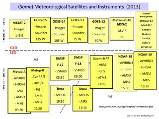
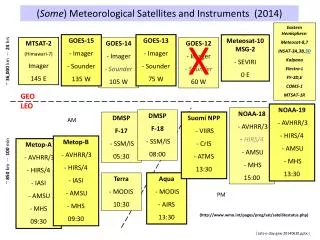
Meteorological Satellites. Prof. Arnon Karnieli The Remote Sensing Laboratory Jacob Blaustein Institute for Desert Research Ben-Gurion University of the Negev Sede-Boker Campus 84990, ISRAEL. Classification by orbit type. Meteosat. Spectral characteristics

E N D
Meteorological Satellites Prof. Arnon Karnieli The Remote Sensing Laboratory Jacob Blaustein Institute for Desert Research Ben-Gurion University of the Negev Sede-Boker Campus 84990, ISRAEL
Meteosat Spectral characteristics Visible 0.5 – 0.9 m 2.5 km Water vapor 5.7 - 7.1 m 2.5 km Thermal 10.5 – 12.5 m 5 km
Meteosat Scanning scheme
Meteosat Location and ground cover
Meteosat Visible band (0.5 – 0.9 m)
Meteosat Water vapor band (5.7 - 7.1 m)
Meteosat Thermal band (10.5 – 12.5 m)
NOAA-AVHRR characteristics • Ground resolution: 1X1 km • SWATH: 2,400 km • Revisit time: ~1 day at HRPT station. • 5 spectral bands: • Red: 0.58 – 0.68 m • Near-infrared (NIR): 0.725 – 1.1 m • Middle infrared: 3.55 – 3.93 m • Thermal (T4): 10.3 – 11.3 m • Thermal (T5): 11.5 – 12.5 m
NOAA-AVHRR Morning and afternoon orbits
NOAA-AVHRR Scanning scheme
NOAA-AVHRR HRPT cover
NOAA-AVHRR NOAA-AVHRR R,G,B = 2,1,1
NOAA-AVHRR Biophysical Indicators 1. The Normalized Difference Vegetation Index: NDVI = (NIR-Red)/(NIR+Red) 2. Land Surface Temperature: Split-Window technique (Price 1984): LST = T4 + A(T4 - T5) + B LST is temperature in degrees Celsius A,B = ƒ(,) LST 1.6
NOAA-AVHRR NDVI = (NIR-Red)/(NIR+Red)
Urban Heat Island Chengdu City, China
NOAA-AVHRR Sea surface temperature Gulf Stream
NOAA-AVHRR Biomass burning detection
NOAA-AVHRR Forest Fire (1000K) 3.5