Download
1 / 32
320 likes | 462 Views
EARTH’S STRUCTURE. Drifting Continents. Piecing It All Together

E N D
Drifting Continents Piecing It All Together German scientist Alfred Wegener noticed that the coastlines of some continents seem to fit together like a jigsaw puzzle. Look at the world map below and see if you can match the continents that seem to line up. What might this mean?
Continental Drift • German scientist Alfred Wegener developed the idea that the continents were once _joined together_ in a single landmass and have since _drifted apart_. • He called this single landmass Pangaea . • His idea became known as Continental Drift .
The Evidence Wegener used three types of evidence to support his idea:
Evidence from landforms included mountain ranges on the continents of South America and Africa that line up when maps of the continents are put together. Also, coal fields in Europe and North America match up.
Evidence from fossils included Glossopteris, a fernlike plant that lived 250 million year ago, and the freshwater reptiles Mesosaurus and Lystrosaurus. Mesosaurus and Lystrosaurus were both freshwater reptiles. These fossils have been found in places that are now separated by oceans. Glossopteris fossils have been found in Africa, South America, Australia, India, and Antarctica.
Spitsbergen • Evidence of climate change included fossils of tropical plants on the island of Spitsbergen in the Artic Ocean. Why is this evidence that the continents might have moved? The live plant The fossil
Drifting Continents Pangaea and Continental Drift Many types of evidence suggest that Earth’s landmasses were once joined together.
Scientists Reject Wegener’s Theory • At the time, most scientists rejected Wegener’s hypothesis because he could not identify the force that pushes or pulls the continents. • For nearly half a century, from the 1920s to the 1960s, most scientists paid little attention to the idea of continental drift. Then new evidence surfaced…
Continental Drift Foldable • Grading Rubric • Provide a complete description of Wegener’s theory (30 pts) • Provide a complete description of the 3 types of he evidence used to support his theory (30 pts) • Neat and legible (10 pts) • Colorful illustrations (10 pts) • Turned in today (20 pts)
Mid-Ocean Ridge Scientists using sonar to map the ocean floor in the 1940s discovered long chains of mountains that rise up from the ocean floor. These are called mid-ocean ridges , and they extend into all of Earth’s oceans.
Sea-Floor Spreading Ocean Floors Mid-ocean ridges rise from the sea floor like stitches on the seams of a baseball.
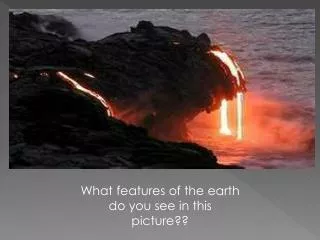
At the mid-ocean ridge, molten material from inside Earth rises, erupts, cools, and hardens to form a solid strip of rock. This process is called sea-floor spreading and it adds more crust to the ocean floor. At the same time, older strips of rock move outward from either side of the ridge.
mid-ocean ridge Mid-ocean ridge erupting Pillow lava
Sea-Floor Spreading In the central valley of mid-ocean ridges, geologists discovered pillow lava. These rocks form only when molten material hardens quickly after erupting under water. The pattern of magnetic stripes on one side of a mid-ocean ridge is usually a mirror image of the pattern on the other side of the ridge. Sea-Floor Spreading Some mid-ocean ridges have a valley that runs along their center. Evidence shows that molten material erupts through this valley and then hardens to form the ocean floor. Scientists tested the age of rock samples taken from the ocean floor. The youngestrocks were always found at the center of the ridges. The farther away the rock sample was taken, the older the rock was.
In a process taking tens of millions of years, the ocean floor moves away from the mid-ocean ridge. As it moves, it cools and becomes more dense . Eventually, the crust might collide with the edge of a continent where gravity pulls the older, denser crust down into a deep underwater canyon called a deep ocean trench and back into the mantle . This process is called subduction .
Sea-Floor Spreading Deep-Ocean Trenches The deepest part of the ocean is along the Mariana Trench. Several trenches in the Pacific Ocean are shown in yellow.
Sea-Floor Spreading Subduction Oceanic crust created along a mid-ocean ridge is destroyed at a deep-ocean trench. During the process of subduction, oceanic crust sinks down beneath the trench into the mantle. Sea-floor spreading and subduction work together. These processes support the idea of continental drift.
Earth’s Interior The three main layers of Earth are the crust , the mantle , and the core . The crust and the upper mantle are grouped together into a single layer called the lithosphere . The lithosphere is broken into large pieces called plates that are separated by cracks. Below the lithosphere, the material is hotter and under increasing pressure. As a result, the part of the mantle just beneath the lithosphere is less rigid than the rock above, although it is still solid. This softer layer is called the asthenosphere .
Earth’s lithosphere, its solid outer shell, is like an eggshell broken into pieces separated by cracks. These pieces are called plates. Earths plates meet at boundaries.
Convection and the Mantle Heat from the Earth’s core and the mantle itself causes convection in the mantle. Convection occurs when the heat from Earth’s core causes the mantle material to become hotter. The hotter rock is less dense and rises toward the crust. As it moves further from the core, it cools off, becomes more dense , and sinks back through the mantle. Over and over, the cycle of rising and sinking takes place, and is known as convection currents .
Convection and the Mantle Earth’s plates move because they are the top part of the large convection currents in Earth’s mantle.
The Theory of Plate Tectonics Plates move apart from each other, or diverge, at a divergent boundary. Most divergent boundaries occur in the oceans at the mid-ocean ridge . Where plates diverge on land, a deep valley called a rift valley forms. Divergent Boundaries
The Theory of Plate Tectonics Plates come together, or converge, at a convergent boundary. What happens when two plates collide depends on the density of the plates. Volcanoes often form where two plates collide. Convergent Boundaries
The Theory of Plate Tectonics Plates slip past each other, moving in opposite directions, at a transform boundary. Earthquakes often occur when the plates suddenly slip along the boundary that they form. Transform Boundaries
The Theory of Plate Tectonics • Scientists combined what they knew about sea-floor spreading, Earth’s plates, and plate motions into a theory called plate tectonics . The theory of plate tectonics states that Earth’s plates are in slow, constant motion, driven by convection currents in the mantle. Plate tectonics explains the formation, movement, and subduction of Earth’s plates. • Scientists use satellites to measure plate motion precisely. The plates move very slowly – from about 1 to 12 centimeters per year. Over millions of years the movement of Earth’s plates has greatly changed the location of the continents and the size and shape of the oceans .
The Theory of Plate Tectonics Earth's Changing Crust As plates move, they produce mountains, volcanoes, and valleys as well as mid-ocean ridges and deep-ocean trenches. Use the terms from the list to label the diagram.
Monitoring Earthquakes Earthquakes Around the World Earthquakes are closely linked to plate tectonics. The map shows where past earthquakes have occurred in relation to plate boundaries.
Monitoring Earthquakes Earthquake Risk The map shows areas where serious earthquakes are likely to occur, based on the location of past earthquakes across the United States.
Volcanoes and Plate Tectonics The Ring of Fire The Ring of Fire is a belt of volcanoes that circles the Pacific Ocean. As with most of Earth’s volcanoes, these volcanoes form along boundaries of tectonic plates.