Download

1 / 26
260 likes | 420 Views
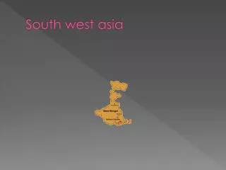
South West Study Area Introduction. Summary of Study Area Unified Development Code Amendments Points of Interest Staff Recommendation Review Schedule of Meetings. South West Study Area.

E N D
South West Study AreaIntroduction • Summary of Study Area • Unified Development Code Amendments • Points of Interest • Staff Recommendation • Review Schedule of Meetings
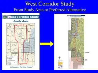
South West Study Area • Area generally bounded by Highway 59, Hwy 36, Hwy 190 the Tchefuncta River, the Tangipahoa Parish Line and Lake Pontchartrain • From the eastern edge of Mandeville to Abita Springs to Goodbee to Madisonville • Four quadrants created by I-12 and the Tchefuncta River
Points of Note • The South West Study Area has undergone similar pattern of development but on three different timelines • Older areas of the southeast and northeast quadrants have long established development patterns • The southwest quadrant underwent a dramatic increase in development pressures in the late 1990’s • The northwest quadrant has undergone an increase in development pressure in the last 5 years
Points of Note • The northwest quadrant has undergone an increase in development pressure in the last 5 years • Each distinct growth period has had different standards of development and infrastructure requirements • This ordinance and other recently adopted standards are an attempt to improve on the previous requirements
Points of Note • Density should be assigned to areas where infrastructure can be constructed without having a significant impact upon the adjacent communities • Higher density development should be placed in areas which are less susceptible to catastrophic impacts of tropical storm events. • Due to an increase in elevation, I-12 is the traditional line of evacuation for St. Tammany Parish
Commercial Centers and Town Centers should be separated so as not to strip out commercial corridors • Industrial or Heavy Commercial centers must be placed where adequate highway infrastructure can be built if not already available
South of Interstate 12 • South of I-12 is either heavily developed with established development patterns or undergone considerable developmental review in the last ten years • These existing developments have established a relatively consistent pattern of development both east and west of the Tchefuncta River • Environmental issues and physical barriers limit the developmental capacities of the southern half of the South West Study area • The threat of tidal inundation by storm events suggest that concentrations of higher density should be avoided
South of Interstate 12 • Commercial activities should be located concentrated at existing centers at Mandeville, Madisonville, and interstate intersections. • While some concentrations of density exist, any additional residential development south of US 190 should be of lower density. • Some small scale existing commercial will remain, particularly along Louisiana Highway 22.
Staff RecommendationSouth of I-12 • Approximately 79% of property designated residential (A or E Districts). • Approximately 21% of property designated commercial, institutional or mixed use. • Density of all Residentially Zoned Property (A or E Districts) is 1.40 units per acre. • Density of all property is 1.11 units per acre.
North of Interstate 12 • The relative lack of development would normally permits planning and construction of transportation, drainage and other infrastructure. • However, environmental issues and physical barriers limit the developmental capacities of the northwest quadrant of the South West Study area . • Towns, crossroad communities and the interstate intersections form the “Commercial and Town Centers” in this area. • Existing centers should be developed with growth focused around these existing centers.
North of Interstate 12 • Areas along the Tchefuncta River and west of Louisiana Highway 1077 (north of U.S. 190 and Bedico Creek (between U.S. 190 and I-12) are particularly sensitive. • Significant acreage of environmentally sensitive property located north of I-12 should be designated as lower density districts. • While concentrations of higher density are more appropriate north of I-12, these must be located within relatively limited areas which are not as environmentally sensitive.
Staff RecommendationNorth of I-12 • Approximately 80% of property designated residential (A or E Districts). • Approximately 20% of property designated commercial, institutional or mixed use. • Density of all Residentially Zoned Property (A or E Districts) is 1.20 units per acre. • Density of all property is .96 units per acre.
Staff Recommendation • Approximately 79% of property designated residential (A or E Districts). • Approximately 21% of property designated commercial, institutional or mixed use. • Density of all Residentially Zoned Property (A or E Districts) is 1.31 Units per acre. • Density of all 95 square miles is 1.04 units per acre.
Review Schedule of Meetings • Special Public Hearings • October 21, 2008 • November 18, 2008 • Presentation to Council in December for additional hearings as needed by Parish Council prior to adoption
Project Website http://www.stpgov.org/departments_planning_rezoning.php Project E-mail Address rezoning@stpgov.org