Download
1 / 28
280 likes | 423 Views
Maintaining and Improving the AMSR-E and WindSat Ocean Products Frank J. Wentz Remote Sensing Systems, Santa Rosa CA. AMSR TIM Agenda 4-5 September 2013 Mandalay Beach, CA. AMSR-E and WindSat Algorithm Improvements. Retrieve accurate wind speeds when rain is present

E N D
Maintaining and Improving the AMSR-E and WindSat Ocean Products Frank J. Wentz Remote Sensing Systems, Santa Rosa CA AMSR TIM Agenda 4-5 September 2013 Mandalay Beach, CA
AMSR-E and WindSat Algorithm Improvements • Retrieve accurate wind speeds when rain is present • Mitigate RFI contamination • Remove sun glitter contamination • Assign error bars to each and every retrieval
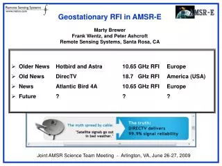
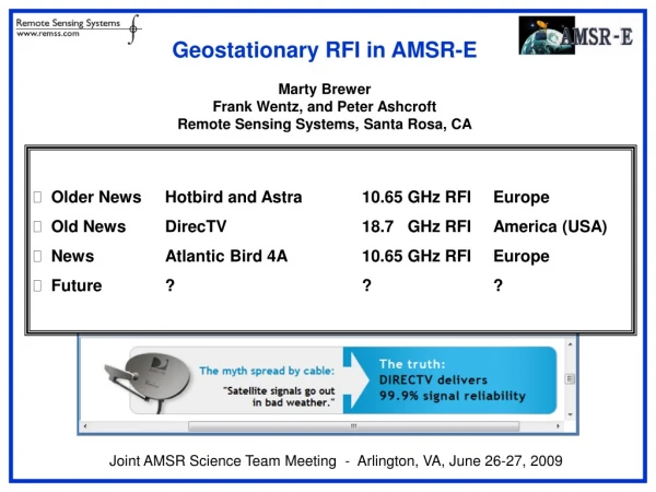
Sun Glitter Removal Based on Recent Work Removal of Galactic Reflections for Aquarius
Assignment of Error Bars Error Bars and Dynamic Quantities
Proposed Future Work for AMSR-E and WindSat • Retrieve accurate wind speeds when rain is present • Mitigate RFI contamination • Remove sun glitter contamination • Assign error bars to each and every retrieval
Using WindSat as a Calibration Bridge from AMSR-E to AMSR-2 Frank J. Wentz Remote Sensing Systems, Santa Rosa CA AMSR TIM Agenda 4-5 September 2013 Mandalay Beach, CA
Climate Change: Hydrologic Cycle and General Circulation Probably the Greatest Consequences of Our Warming Climate will be Related to Changes to Hydrologic Cycle and General Circulation: Drought, Floods, Severe Storms Is the Hydrologic Cycle Accelerating? Is the Walker Circulation Intensifying? Is the Hadley Cell becoming More Energetic? How will Precipitation Increase with Global Warming?
35-Years of Microwave Earth Observations • GCOM-W and GCOM-W2 Continues the Advancement
Quarter Century Trend Maps of Wind and Vapor Regional Trend Patterns are 5+ times larger than the estimated 2-sigma error. They are real.
Intensification of Walker Circulation as Evidenced by Increasing Surface Winds in the Tropical Pacific Sea-Surface Height, 1993-2011 SST Trend = -0.155 K per decade Wind Trend = 0.387 m/s per decade
Discrepancies in Wind Trends Satellite Wind Trends (1988-2011) Mean CMIP-3 Wind Trends (1976-1999) Nino-4 MERRA Wind Trends (1988-2011) ERA-Interim Wind Trends (1988-2011) High Wind Trends from Altimeters Trend Discrepancies in NINO4 Region
Climate Models Do Not Produce True Large-Scale, Quarter-Century Climate Features
Discrepancies in Vapor Trends Standard Error in Satellite Trend Estimated to be 0.05 mm/decade (0.2%/decade)
Engineering Climate Data Records Version-7 Calibration Methodology Validation EP Adjustments (i.e., clear sky bias, high vapor bias) Geophysical Retrievals Automatic Retrieval Algorithm Radiative Transfer Model Simulated Antenna Temperatures Cycle Time ≈ ½ Year Sensor Adjustments Calibration RTM Adjustments Sensor Antenna Temperatures • Precision of 0.1 K or smaller • Use same RTM for calibrating all satellites • Use RTM-1for same retrieval algorithm for all satellites
Inter-Comparison of Radiometer Wind Time Series F13 SSMI, F16 & F17 SSM/IS, WindSat (F31), and AMSR-E (F32) Agreement is at 0.1 m/s Level F16 SSM/I Problem
Inter-Comparison of Radiometer Vapor Time Series F13 SSMI, F16 & F17 SSM/IS, WindSat (F31), and AMSR-E (F32) Agreement is at 0.1 mm Level AMSR-E > WindSat: Vapor in Rain
WindSat as a Calibration Bridge to AMSR-2 • Both AMSR-E and WindSat are at the V-7 Calibration Standard • WindSat is Very Stable • Years of Analysis have gone into comparing WindSat and AMSR-E • Diurnal differences are mostly understood • Goal: Make AMSR-2 versus WindSat look like AMSR-E versus WindSat
Proposed Calibration Methodology WindSat Ocean Productsare accurate: SST, Wind, Vapor, and Cloud (T,W,V,L) They have been thoroughly validated and will be continue to be validated Ocean Radiative Transfer Model (RTM) is highly accurate 0.2 K absolute (TBD), and 0.1 K relative Meissner and Wentz (2012): IGARSS Paper of the Year Award Publically available RTM[ T,W,V,L from WindSat ] Highly accurate simulated AMSR-2 Brightness Temperatures Same Version-7 Calibration Method use for other MW radiometer: 6 SSM/I, 2 SSM/IS, AMSR-E, and WindSat (soon TMI) Primary Calibration Adjustments: Mean Hot Load Temperature: -1.8 K for 6-37 GHz; -0.8 K for 89 GHz APC Non-Linear correction Amazon Forest calibration needed because of non-linearity issue.
Receiver Non-Linearity is an Important Issue for AMSR-2 Each image shows a separate channel. All 16 channels are shown. Red Curves are JAXA Non-Linear Correction ( MarehitoKasahara 21 Feb 2013 presentation) Black Curves are preliminary values coming from our analysis.
Ocean Calibration Difference of AMSR-2 TB Minus RTM TB using WindSat Retrievals Before Vapor/Cloud Diurnal Adjustment After Vapor/Cloud Diurnal Adjustment 6.9 H 10.7H 18.7H 23.8H 37 H
Amazon Forest Calibration Before Adjusting Hot-Load Temperature, APC, and Non-Linear Correction Black triangles are WindSat. Red triangles are AMSR-E. Green triangles are AMSR-2. Colored squares are the 6 SSM/Is Same months used for averages, but averaging years are different.
Amazon Forest Calibration After Adjusting Hot-Load Temperature, APC, and Non-Linear Correction Black triangles are WindSat. Red triangles are AMSR-E. Green triangles are AMSR-2. Colored squares are the 6 SSM/Is Same months used for averages, but averaging years are different.
Closure Analysis: AMSR-2 TB minus RTM with AMSR-2 Ocean Retrievals Each image shows a separate channel. All 16 channels are shown. Only Ascending Orbit Segments
Closure Analysis: AMSR-2 TB minus RTM with AMSR-2 Ocean Retrievals Each image shows a separate channel. All 16 channels are shown. Descending Minus Ascending Orbit Segments
Conclusions • We Expect AMSR-2 will Significantly Advanced Our Understanding of Climate Change. • The Various Calibration Issues are Typical for Satellite Microwave Radiometers, Although the Receiver Non-Linearity is a Bit Unusual. • RFI Continues to be Worrisome but Adaptive Mitigation Strategies Can be Employed