Download
1 / 1
20 likes | 165 Views
Center for Embedded Networked Sensing. Improving Personal and Environmental Health Decision Making with Mobile Personal Sensing.

E N D
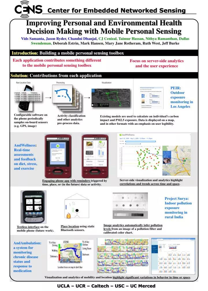
Center for Embedded Networked Sensing Improving Personal and Environmental Health Decision Making with Mobile Personal Sensing Vids Samanta, Jason Ryder, Chandni Dhanjal, CJ Cenizal, Taimur Hassan, Nithya Ramanthan, Dallas Swendeman,Deborah Estrin, Mark Hansen, Mary Jane Rotheram, Ruth West, Jeff Burke Introduction: Building a mobile personal sensing toolbox Each application contributes something different to the mobile personal sensing toolbox Focus on server-side analytics and the user experience Solution: Contributions from each application PEIR: Outdoor exposure monitoring in Los Angeles Configurable software on the phone periodically samples on-board sensors (e.g. GPS, image) Activity classification and other analytics pre-process data. Existing models are used to calculate an individual’s carbon impact and PM2.5 exposure. Data is displayed on a map, and in other formats with an emphasis on user legibility. AndWellness: Real-time assessments and feedback on diet, stress, and exercise Server-side visualization and analytics highlight correlations and trends across time and space. Engaging phone app with reminders triggered by time, place, or (in the future) data or activity. Project Surya: Indoor pollution exposure monitoring in rural India Image analytics automatically infer pollution levels from an image of a pollution filter and calibrated color chart. Place location using static Bluetooth sensors. Textless interface on the mobile phone (future work). AndAmbulation: a system for monitoring chronic disease status and response to medication Visualization and analytics of mobility and location highlight significant variations in behavior in time or space. UCLA – UCR – Caltech – USC – UC Merced