Download
1 / 11
110 likes | 241 Views
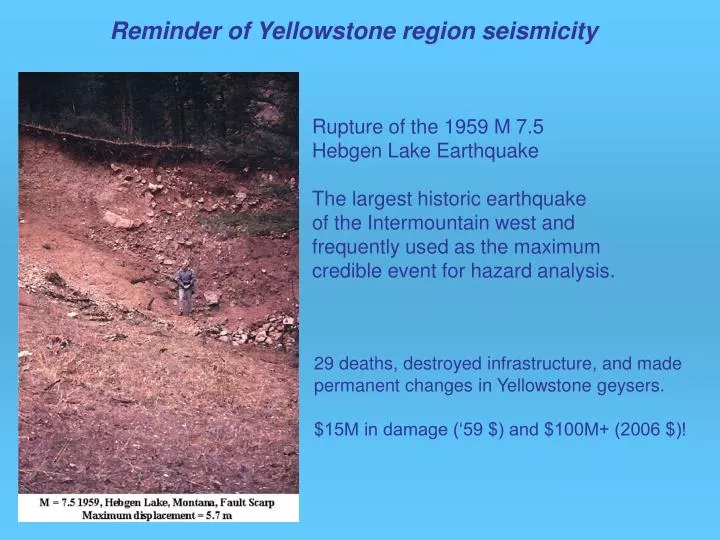
Reminder of Yellowstone region seismicity. Rupture of the 1959 M 7.5 Hebgen Lake Earthquake The largest historic earthquake of the Intermountain west and frequently used as the maximum credible event for hazard analysis.

E N D
Reminder of Yellowstone region seismicity Rupture of the 1959 M 7.5 Hebgen Lake Earthquake The largest historic earthquake of the Intermountain west and frequently used as the maximum credible event for hazard analysis. 29 deaths, destroyed infrastructure, and made permanent changes in Yellowstone geysers. $15M in damage (‘59 $) and $100M+ (2006 $)!
Hebgen Lake fault M 7.5, 1959 M 6.2, 1975 1985 swarm Yellowstone: An Active Seismo-Volcanic System Deformation measured by geodetic methods. Magnitudes converted to seismic moment. 1000 to 4000 events per year. Hypocenter locations using 3D velocity model. The 0.64 My caldera boundary is in orange. Color patterns are hydrothermal features.
Combined Earthquake and Volcano Risk of Yellowstone-Grand Teton Region • With over 6 million visitors per year, total in both parks plus surrounding communities, the exposure is similar to that of an urban center. • Given that these areas are in a remote location with confined transportation corridors, limited large-scale emergency response, etc. as well as a generally unprepared visitor-population to such hazards, this condition sets this area apart in anurban risk category. • This is an important theme for the USGS NEHRP and Volcano Hazards Programs.
Yellowstone-Teton Probabilistic Seismic Hazard Assessment(2% in 50 years) Yellowstone-Teton PSHA (White and Smith, 2006) Western U.S. PSHA (USGS) Y-T
Integrated Yellowstone Seismic Network, 21 SP & 6 BB stations (current)(UUSS, YVO, including an ANSS-Teton station, NSF, Research Foundation) -FBA
USArray broadband adoption possibilities 2007-2008, 5 stations
EarthScope-PBO 5 borehole dilatometer strainmeters, 2006-2008
EarthScope-PBO 5 three-component borehole dilatometers and seismometers, 2006-2008
Yellowstone GPS Network, 22 stations current/being installed(EarthScope-PBO, UU, YVO) - 2006 install
An Integrated Yellowstone Monitoring Network (UU, YVO, UUSS, PBO, ANSS, USArray)