Download
1 / 31
320 likes | 510 Views
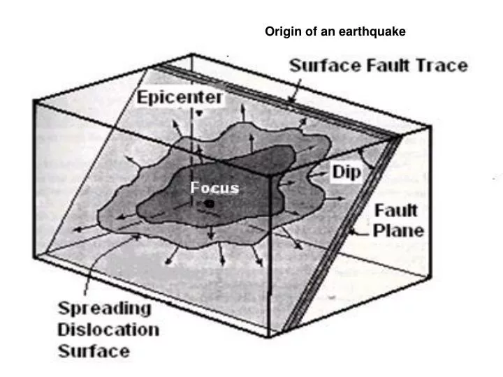
Origin of an earthquake. Epicenter: It is the point on the (free) surface of the earth vertically above the place of origin (hypocenter/focus) of an earthquake. This point is expressed by its geographical latitude and longitude. Hypocenter or Focus:

E N D
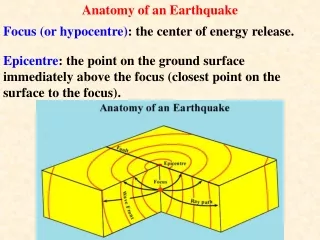
Epicenter: It is the point on the (free) surface of the earth vertically above the place of origin (hypocenter/focus) of an earthquake. This point is expressed by its geographical latitude and longitude.
Hypocenter or Focus: It is the point within the earth from where seismic waves originate. Focal depth is the vertical distance between the hypocenter and epicenter.
Magnitude: It is the quantity to measure the size of an earthquake in terms of its energy and is independent of the place of observation.
Richter Scale: Magnitude is measured on the basis of ground motion recorded by an instrument and applying standard correction for the epicentral distance from recording station. It is linearly related to the logarithm of amount of energy released by an earthquake and expressed in Richter Scale.
Intensity: It is the rating of the effects of an earthquake at a particular place based on the observations of the affected areas, using a descriptive scale like Modified Mercalli Scale.
Plot of Earthquakes (M>= 5.0) From IMD Catalogue for the period from 1800 to Sept, 2001 M = 5 smallest circle, M = 6 smaller circle , M = 7 larger circle M = 8 largest circle
Plate Tectonic: It is based on some theoretical assumptions that explain the forces, which cause accumulation of stresses inside the earth. These assumptions are as given below: Drifting of continents and mountain building process Shortening of Earth’s crust due to cooling and contraction. Disturbance of mass distribution on the Earth’s surface as a result of erosion of high lands and deposition of sediment in the sea. Generation of heat by radioactive material inside the Earth’s crust.
Plate Boundaries Plate Boundaries
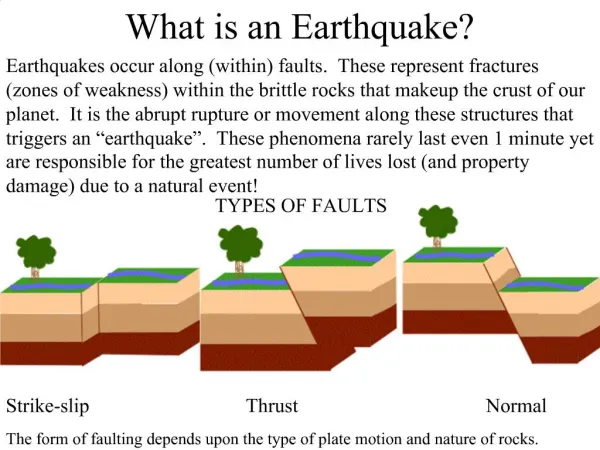
Faults Unfaulted Block
Seismic waves Body Waves
Building classification: Buildings can be graded as to the amount of overall fire resistance required by taking into account the size of building, function character of building and the fire load • Grade 1 – (1 hr). Typical buildings within this grade are flats, offices, restaurants, hotels, hospitals, schools, museums and public libraries. • Grade 2 – (2hr) Moderate fire load, typical examples are retail shops, factories and workshops. • Grade 4 – (4 hr) High fire load, Typical examples are certain types of workshop and warehouses
STATUS OF EARTHQUAKE MONITORING Indian Meteorological Department (IMD) is the nodal agency dealing with measuring arthquakes in India. At present IMD is maintaining a network of 51 seismological observatories. Twenty-four seismological observatories were upgraded with broadband digital seismographs during 1996-99. A Central Receiving Station (CRS ) and a National Seismological Data Base Centre (NSDC) have been established at New Delhi to receive analyze and systematically archive the seismic data.