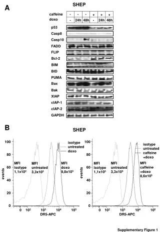
Download
1 / 2
20 likes | 161 Views
Snow and soil moisture response across elevation, aspect and canopy variables in a mixed-conifer forest, Southern Sierra Nevada. Roger Bales a , Matt Meadows a , Jan Hopmans b , Peter Hartsough b , Peter Kirchner a

E N D
Snow and soil moisture response across elevation, aspect and canopy variables in a mixed-conifer forest, Southern Sierra Nevada Roger Balesa, Matt Meadowsa, Jan Hopmansb, Peter Hartsoughb, Peter Kirchnera aSierra Nevada Research Institute, University of California, Merced; bDept. Land, Air and Water Resources, University of California, Davis
White fir Incense cedar Location and layout Soil became wetter as snowmelt progressed, then dried across all sites. Upper Lower Instruments were placed in 5 nodes at 2 elevations, covering N, S and flat aspects. Each node has 5-7 sets of sensors arrayed around 2-3 trees. F F F F F F F F F F F F M M M M M M M M M M M M A A A A A A A A A A A A M M M M M M M M M M M M J J J J J J J J J J J J J J J J J J J J J J J J A A A A A A A A A A A A S S S S S S S S S S S S F F M M A A M M J J J J A A S S Acoustic depth sensors were placed over each soil moisture pit to record snow accumulation and depletion Pits were excavated and Echo TM probes placed at depths of 10, 30, 60 and 90 cm At each node, sensors were placed under tree canopies, at the drip edge and in the open. At lease two trees were instrumented at each aspect and elevation First-year (2008) results from 97 soil and 27 snow sensors arrayed around 11 trees at 3 aspects and 2 elevations Interpretation Background A water-balance instrument cluster that included distributed snow-depth measurements and vertical profiles of soil temperature and volumetric water content was deployed in summer and fall of 2007 at the Southern Sierra Critical Zone Observatory (CZO), at an elevation of 1,600-2,000 m. The CZO is co-located with the Kings River Experimental Watersheds, a U.S. Forest Service integrated watershed research site. Instruments were deployed to capture both north- and south-facing aspects, as well as differences in canopy cover across the instrument cluster. Snow accumulation & melt Snow is generally deeper at the upper sites (left 3 panels) than lower sites (right 2 panels), resulting in earlier drying of surface soils for the lower elevation sites. Soil moisture profiles show higher surface than subsurface soil moisture in the winter, with an inversion occurring in the spring and summer, causing lower soil moisture at the soil surface than at depths. This is likely due to soil evaporation. Temporal variations in soil moisture are very consistent. Soil moisture is high in the winter, followed by decreases in the spring and summer, with periodic rises in soil moisture with rain in mid-May and mid-July. Peak snow depth occurred on Feb 25; 3 weeks later over 1/3 of the snow had melted and the lower south site was nearly snow free. Snow persisted for up to 8 weeks at the upper north site. Rainfall response Shallow soil moisture responds much more to rain than do deeper depths, which is expected. Deeper soil moisture responses at some sites (e.g. upper south, oak) may be due to preferential flow caused by either by sensor installation or macropores associated with roots, rocks, etc. Macopores were observed during installation at several sites. Sensors under the canopy failed to show a rainfall response in July. Evapotranspiration Late summer water contents at all depths approach low values across all sites, indicating that tree water uptake exploits the whole root zone. If no water is available at the shallower depths, tree roots become more active at the lower soil depths. Some of the inverted soil moisture profiles could be due to near soil surface evaporation,with root water uptake occurring at all depths. At open sites, soil moisture may be lower deeper because of fewer tree roots, whereby the lower surface soil moisture is mainly caused by soil evaporation. Soils are largely decomposed granite; however, organic content in near-surface soils influenced measured values of volumetric water content in locations where liter was present. Legend Each of the 5 columns of soil temperature and soil moisture figures shows 8 months of data from one node. The top panel of each column shows snow depth and legend for tree species. Gray curve in background on snow and soil temperature panels is air temperature. Calibration Laboratory testing of the Echo soil moisture sensors show that uncertainty is likely not to exceed 5 volume percent .The laboratory calibration also showed that there may be significant under-estimation at near-zero soil moisture. The limited concurrent soil moisture instrument and gravimetric measurements at 5 selected sites show increasing uncertainty for the near-soil surface measurements. We note that sampling spacing between sensors and gravimetric sites are as much as 1 m, thus causing differences in soil moisture, irrespective of the accuracy of the soil moisture sensor or errors in gravimetric sampling. In addition, we note that the Echo soil moisture readings may become increasingly uncertain as soil temperature reaches 0 0C. We are planning to further investigate the accuracy of the Echo soil moisture probes close to near-zero temperatures Vertical variations in soil moisture are larger during winter at most sites, and differences in soil moisture with depth decreases as the summer progress. Variations observed at deep sensors during winter are likely caused by snow melting, whereas smaller summer variations (with depth) are reflective of tree water uptake occurring at all depths. Soil Temperature Soil temperatures at the upper sites are generally lower during winter than at the lower sites, but there are no clear differences in spring and summer. Soil temperature at all 5 sites decreased sharply with the in mid-May rain, apparently due to infiltration of cold rainwater. Acknowledgments Research is supported by the National Science Foundation through the Southern Sierra Critical Zone Observatory and a Major Research Instrumentation grant.