Download
1 / 16
160 likes | 294 Views
Earthquake Commission (EQC) founded 1944 funded by levy on fire insurance covers house damage up to NZ $100,000 (£50,000), plus contents up to NZ $20,000 (£10,000), and land damage under house more than 100,000 Christchurch claims from 4 September event (including more

E N D
Earthquake Commission (EQC) • founded 1944 • funded by levy on fire insurance • covers house damage up to NZ $100,000 • (£50,000), plus contents up to NZ $20,000 • (£10,000), and land damage under house • more than 100,000 Christchurch claims • from 4 September event (including more • than 2000 uninhabitable houses)
Aftershocks during September / October www.geonet.org.nz/resources/earthquake/recent-regional-seismicity/shallow-seismicity.html
Aftershocks during November/December www.geonet.org.nz/resources/earthquake/recent-regional-seismicity/shallow-seismicity.html
Boxing Day aftershock sequence (24 hrs recorded at McQueen’s Valley, ~ 30 km SE of Christchurch) www.geonet.org.nz/earthquake/drums/mqz-drum.html
Press, 27 December 2010 A largely linear pattern to the Boxing Day aftershocks - pointed to a fault running through the City (and in particular under the CBD, represented here by the black square)
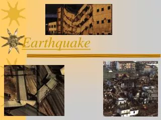
22 February 2011 12.51am NZT Magnitude 6.3 Depth 5km Epicentre around 5km southeast of Christchurch Human toll: 181 deaths (1 unaccounted for) Estimated financial cost: approx. NZ $15 billion
Port Hills fault - major aftershocks 22-24 Feb 2011 The Star, 25 February 2011
USGS map of exposure to shaking, reproduced in New Zealand Historic Places Trust, Kia Kaha Canterbury
Maximum vertical acceleration recorded at Heathcote (about 1km from epicentre) ~ 2.2g ( a measured world record !) J Berrill, ‘Some Aspects of the M 6.3 February 22nd Earthquake’ (reproduced in the Press, 24 March 2011)
The Star, 25 February 2011 Reasons for vertical shaking intensity: 1) closeness of fault 3) focusing by Port Hills towards city 2) steep angle (65%) of fault 4) amplification by gravel layers
B A Maritime Museum, Lyttelton - photo V Wood; Lancaster Park - photo Greg Bowker, APN/The Star, Earthquake 6.3
Three before & after images of Gothic Christchurch Christchurch Cathedral http://www.nzherald.co.nz/christchurch-earthquake-photos/ news/image.cfm?c_id=1503036&gallery_id=116929#7381709 (accessed 10 June 2011)
Canterbury Provincial Chambers Photos / Flickr user Kate's Photo Diary , SimonBaker
Churches not exposed to 1g+ vertical acceleration (e.g. St Peter’s at Riccarton) suffer much less damage - photo V Wood