Download

1 / 15
150 likes | 319 Views
U.S. Coral Reef Task Force Meeting, October 2003. NOAA's Oceans & Coasts Center for Coastal Monitoring and Assessment. Status of Integrated Mapping and Monitoring of Shallow-water U.S. Coral Reef Ecosystems. Integrative Mapping, Monitoring & Assessment.

E N D
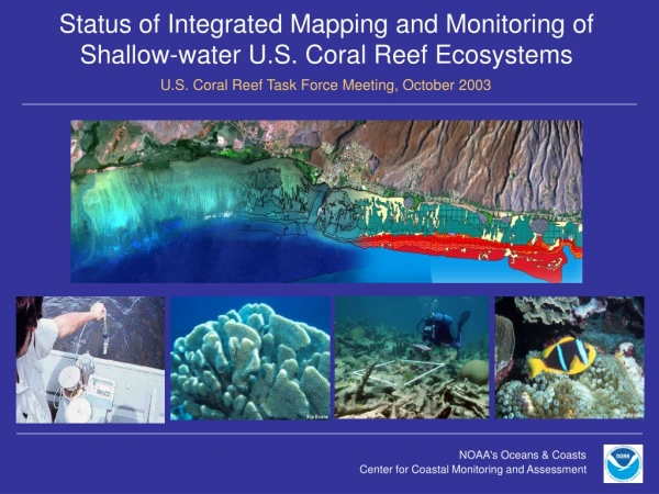
U.S. Coral Reef Task Force Meeting, October 2003 NOAA's Oceans & Coasts Center for Coastal Monitoring and Assessment Status of Integrated Mapping and Monitoring of Shallow-water U.S. Coral Reef Ecosystems
Integrative Mapping, Monitoring & Assessment U.S. Coral Reef Task Force Meeting, October 2003 Mapping Assessment Monitoring Acquire Imagery Analyze Data Design Sample Protocols Develop Map Implement Monitoring Complete Assessment
NOAA's Oceans & Coasts Center for Coastal Monitoring and Assessment USCRTF Mapping Implementation Plan U.S. Coral Reef Task Force Meeting, October 2003 • Produce digital high resolution maps of shallow-water (<30m) coral reef ecosystem habitats • Delineate and characterize benthic habitats using a hierarchical classification system • Map All U.S. States, Territories, and Commonwealths and the Freely Associated States by 2007 • Integrate maps with research and monitoring activities for use by scientists and managers
U.S. Coral Reef Task Force Meeting, October 2003 U.S. Coral Reef Shallow-water Mapping Status: Florida: CD-rom released 1998; total area mapped ~5,022 sq. km*. U.S. Caribbean: CD-rom released 2001; total area mapped ~2,085 sq. km*. Hawaii-1: CD-rom released 2003; total area mapped ~774 sq. km*. Hawaii-2:Imagery acquired and processed for Lanai; ongoing proof of concept study. NW Hawaiian Islands: CD-rom released 2003; total area mapped ~2,357 sq. km*. American Samoa: Draft maps complete; total area mapped ~73 sq. km*. Training held in May 2003. CNMI (Southern Islands): Complete draft mapsin October 2003; on-site training held in July 2003. CNMI (Northern Islands): Complete draft mapsin June 2004; imagery acquisition in progress. Guam: Complete draft maps in February 2004; imagery acquisition in progress. On-site training to be held December 2003. FAS and Florida-2: Mapping activities proposed to begin in 2004. *All area estimates exclude unknown areas, deep water and land.
NOAA/ NOS Coral Reef Ecosystem Monitoring Program: U.S. Coral Reef Task Force Meeting, October 2003 NOAA's Oceans & Coasts Center for Coastal Monitoring and Assessment OBJECTIVES: 1. Provide leadership in the development and implementation of a nationally-coordinated program to monitor the health of U.S. coral reef ecosystems. 2. Integrate disparate monitoring programs and sites into a coordinated national network. 3. Facilitate sharing of monitoring information among U.S. coral reef resource managers and scientists. 4. Fill gaps in monitoring coverage nationwide. The goal of the coral reef ecosystem monitoring program is to collect a robust and consistent suite of data that can be used to prepare a biennial report documenting the status and trends in the health, community structure, and condition of all US coral reef ecosystems.
NOAA/ NOSCoral Reef Ecosystem Monitoring Program: U.S. Coral Reef Task Force Meeting, October 2003 MONITORING THEMES Benthic Parameters Water Quality Parameters Fishery Parameters Cover (live, dead, etc.) Abundance Condition Size class distribution Indicator species Diversity Nutrients Suspended solids Chlorophyll Turbidity Temperature PAR Abundance & distribution Size class distribution Indicator species Diversity Richness Evenness Examples
NOAA/ NOSCoral Reef Ecosystem Monitoring Program: 2000 2001 2002 2003 2004 2005 2006 2007 Water Quality Water Quality Water Quality Water Quality Water Quality Water Quality Water Quality Water Quality Biological Biological Biological Biological Biological Biological Biological Biological Habitat Habitat Habitat Habitat Habitat Habitat Habitat Habitat American Samoa CNMI Guam Hawai'i Freely Associated States Florida Puerto Rico USVI $2.2M TOTAL FUNDS $444,000 $560,790 $1.1M $1.2M $1.2M $1.4M $1.8M Outyear Projections Total Actual Funds/Year (FY00-02) and Projected (FY03-07) Funds/Year Required to Meet FY2007 Goals $ 3 M $ 2.5M $ 2 M $ 1.5 M $ 1 M $ 0.5 M $0 M 2000 2001 2002 2003 2004 2005 2006 2007
NOAA's Oceans & Coasts Center for Coastal Monitoring and Assessment The State of U.S. Coral Reef Ecosystems: 2004 Report U.S. Coral Reef Task Force Meeting, October 2003 Changes for the 2004 report: 1. Greater role for local experts and working groups in collecting and analyzing data, and writing individual report sections describing each location. 2. Report will appear as an edited volume with POCs and working group members as section authors. 3. Greater incorporation of quantitative data. At a minimum, data funded through NOS will be analyzed, however, working groups should be moving toward incorporation of all relevant, accessible data.
The State of U.S. Coral Reef Ecosystems: 2004 Report U.S. Coral Reef Task Force Meeting, October 2003 Monitoring Data Generated thru NOS Program 2000-02 • Federal agencies • State/ territorial resource mgmt. agencies • Academia • Existing Data Working Groups Other Monitoring Data Sets:
1. Global Warming/ Coral Bleaching 2. Diseases 3. Tropical Storms 4. Coastal Development and Runoff 5. Coastal Pollution 6. Tourism and Recreation 7. Fishing 8. Trade in Coral and Live Reef Species 9. Ships, Boats and Groundings 10. Marine Debris 11. Alien Species 12. Security Training Activities 13. Offshore Oil and Gas Exploration 14. Other
2004 Report: Data Acquisition, Review and Analysis (Tasks 4, 5, 6, 7) scheduled for completion in January 2004. We need USCRTF assistance to ensure that agency staff can actively participate in working groups.
NOAA's Oceans & Coasts Center for Coastal Monitoring and Assessment
Status of Mapping Efforts for U.S. Coral Reefs: Caribbean United States Caribbean: The Caribbean Benthic Habitat CD-rom was completed in 2001 and is being distributed. The effort mapped over 2,085 square kilometers of nearshore benthic habitats on St. Croix, St. Thomas, St. John, Puerto Rico, Desecho, Mona, Culebra and Vieques. The imagery was collected using aerial photography and heads-up digitizing. All materials used in the mapping process, including the digitizing extension, aerial photographs, various polygon shapefiles, legend files, ground control points and accuracy assessment points are available at http://biogeo.nos.noaa.gov. Florida: The Florida Keys Benthic Habitat CD-rom was completed in 1998. Due to the technological advances in imagery collection and a greater sophistication in mapping methodology, it may be highly beneficial to re-map areas represented in the present CD-rom and expand the area of interest to include important coral reef ecosystems and related habitats in adjacent coastal areas of the Atlantic Ocean and Gulf of Mexico.
Status of Mapping Efforts for U.S. Coral Reefs: Pacific (1) Hawaii, Effort 1: The Hawaii Benthic Habitat CD-rom was completed earlier this year and is being distributed. The print atlas version, as requested by the POC and others, is nearing completion. The effort mapped 774 square kilometers of nearshore benthic habitats on all main islands. All materials used in the mapping process are available at http://biogeo.nos.noaa.gov. Hawaii, Effort 2: Hyperspectral imagery for the entire Island of Lanai has been collected. This includes16 flight lines, with 2-3 meter pixel size, an 1/10 an acre MMU, features imaged up to 30 meters in depth; Imagery is >95% obstruction free. Bottom classification is complete for 4 flight lines using new classification scheme: records zone, geomorphic structure, and cover type. This effort uses a hybrid processing approach- a combination of automated and visual processing. NOAA acceptance of the data is required before acquisition begins for the remaining 7 major islands. American Samoa: Draft maps of all the islands (Tutuila, Manua, Rose & Swains atolls) are complete with 95% thematic accuracies. 90% cloud-free IKONOS imagery was acquired for all shallow water areas, orthorectified and distributed to Federal and Island Partners. Horizontal accuracies ~ 7 meters. Training was conducted with local coral reef biologists to transfer mapping capabilities and methodologies. Detailed coral reef Accuracy Assessment (n=652) and ground validation (n = 348) points were collected throughout the islands.
Status of Mapping Efforts for U.S. Coral Reefs: Pacific (2) Northern Marianas Islands: Draft maps of the Northern Islands will be started March 1 and completed by June 2004. NOAA has purchased cloud-free imagery for 5 of the islands; acquisition for the remaining islands is ongoing. Accuracy Assessment and Ground Validation point collection will be conducted by ALH in April 2004. Southern Marianas Islands: Draft maps of all the Islands will be completed by October 2003. 92% cloud-free IKONOS imagery was acquired for shallow waters, orthorectified and distributed to Federal and Island Partners. Horizontal accuracies ~ 7 meters. Training was conducted with CNMI coral reef biologists to transfer mapping capabilities and methodologies. Detailed coral reef Accuracy Assessment (n=519) and ground validation (n=231) points were collected throughout the islands. Guam: Draft maps of Guam will be started November 1 and completed by February 2004. NOAA is in the process of purchasing more cloud-free IKONOS imagery. Training, Accuracy Assessment and Ground Validation collection will be conducted with Guam coral reef biologists December 7 through the 13th.