Download
1 / 34
350 likes | 545 Views
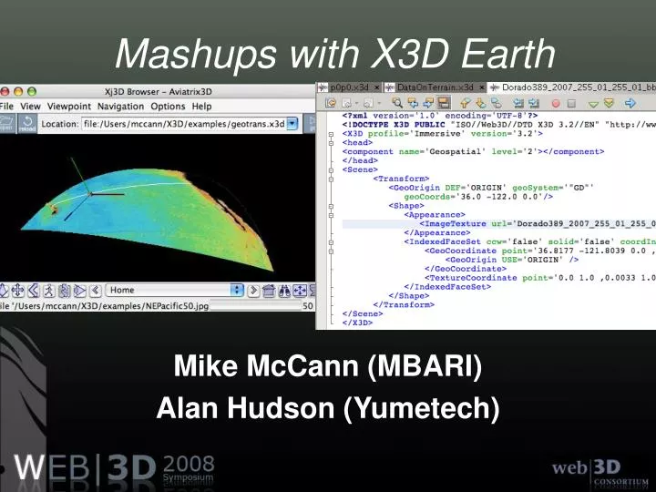
Mashups with X3D Earth. Mike McCann (MBARI) Alan Hudson (Yumetech). Why X3D Earth?. All the benefits of X3D: Open ISO Specification Choice of implementations and tools Scripting capabilities Powerful browsers Geospatial accuracy (WGS84, UTM, etc.)

E N D
Mashups with X3D Earth Mike McCann (MBARI) Alan Hudson (Yumetech)
Why X3D Earth? • All the benefits of X3D: • Open ISO Specification • Choice of implementations and tools • Scripting capabilities • Powerful browsers • Geospatial accuracy (WGS84, UTM, etc.) • True mapping of 3D Geospatial coordinates to X3D’s Cartesian X, Y, Z coordinates
Precision of GeoCoordinates • GeoOrigin concept • Convert Geo coordinates (geographic, UTM, etc.) to Cartesian GeoCentric coordinates • Subtract GeoOrigin coordinates from from the GeoCoordinates in scene • Graphics pipeline deals with smaller numbers that are resolved with single precision arithmetic
GeoCoordinate Examples # GEO lat 21.3… deg, long -157.86… deg, 0 m elevation, WGS84 <GeoCoordinate geoSystem=”’GD’" point="21.316258 -157.886202 0.0" </GeoCoordinate> # UTM zone 11, 4361550.1 n, 310385.2 e, 1000 m elevation <GeoCoordinate geoSystem=”’UTM’, ‘Z11’" point=”4361550.1 310385.2 1000" </GeoCoordinate> (All coordinates translated internally to geocentric)
Use GeoOrigin to increase precision # More precise object & camera positioning <GeoOrigin DEF="ORIGIN" containerField="children” geoSystem=”’GD’” geoCoords="35.0 -135.0 0.0"/> <GeoCoordinate geoSystem=”’GD’" point="21.316258 -157.886202 0.0" <GeoOrigin USE=“ORIGIN”/></GeoCoordinate> (GeoSpatial supports a single GeoOrigin per scene)
How GeoOrigin works • In GeoCentric coordinates: • Define (DP) origin at (3477210.00, -182230.00, 5325900.00) • Specify (DP) point of (3477218.18, -182233.28, 5325900.72) • Take (SP) difference: (8.18, 3.28, 0.72) • Small number single-precision coordinates used in the rendering pipeline
Simplicity of Use • X3D-Earth nodes are built out of GeoCoordinate nodes just as regular Geometry nodes are built out of Coordinate nodes • GeoCoordinates may be specified in WGS84 Lat/Lon, UTM Easting/Northings, or GeoCentric x/y/z coordinates • Nodes like GeoElevationGrid work just like ElevationGrid but with GeoCoordinates
GeoSpatial Node overview • GeoCoordinate - Build geometry with geographic coordinates • GeoElevationGrid - Define height field with geographic coordinates • GeoLocation - Georeference a vanilla X3D model
GeoSpatial Node overview(cont.) • GeoLOD - Multi-resolution terrain level of detail management • GeoMetadata - Dublin Core element style Information about the data • GeoOrigin - Used to increase the precision within the scene
GeoSpatial Node overview(cont.) • GeoPositionInterpolator - Animate objects within the geographic coordinate system • GeoProximitySensor - Provides geographic coordinates of viewer’s position • GeoTouchSensor - Return geographic coordinates of an object
GeoSpatial Node overview(cont.) • GeoTransform - Translate and rotate GeoCoordinate built geometry relative to tangent plane of ellipsoid • GeoVeiwpoint - Specify viewpoint in geographic coordinates
More detail into the Geo nodes • The building blocks of GeoSpatial worlds
GeoCoordinate (1 of 11) • Purpose • Specify a list of geographic coordinates • Usage • Can use a GeoCoordinate node anywhere an X3D Coordinate node can go, e.g. PointSet, IndexedFaceSet, or IndexedLineSet. • Uses • Build models in terms of lat/long or UTM. For example, a road line segment, a GPS track, or 3-D model from GPS-recorded points or model simulation
GeoCoordinate (1 of 11) <Shape> <IndexedLineSet colorPerVertex="false” coordIndex="0 1 2 . . .” <GeoCoordinate point="21.316258 -157.886202 0.0, 21.316262 -157.8862 0.0, 21.31626 -157.886193 0.0, . . .”geoSystem=""GD""> <GeoOrigin USE="ORIGIN"/> </GeoCoordinate> <Color color="1.0 0.0 0.0"/> </IndexedLineSet> </Shape>
GeoElevationGrid (2 of 11) • Purpose • Define a height field using geographic coordinates • Usage • Can use a GeoElevationGrid node anywhere an X3D ElevationGrid can go, e.g. from the geometry field of a Shape node. • Uses • Create terrain models for local or large areas (automatically introduces correct degree of earth curvature)
GeoElevationGrid (2 of 11) <Shape> <Appearance> <ImageTexture url=""NEPacific50.jpg""/> </Appearance> <GeoElevationGridgeoGridOrigin="15.0 -165.0 0.0” height="-5416.0, -5496.0, … xDimension="113" xSpacing="0.5380962885" zDimension="66" zSpacing="0.5415395186”yScale="10.0”/> <TextureCoordinatepoint="0.0 0.0, 0.00892857 0.0, ... /> </GeoElevationGrid> </Shape>
GeoLocation (3 of 11) • Purpose • Georeference a vanilla X3D model onto the surface of the earth • Usage • The GeoLocation node is a grouping node that affects the location of its children. It also sets the orientation so that +Y is up for that location. • Uses • Place a non-georeferenced model at its correct location and orientation, place an X3D Viewpoint or ElevationGrid at a geographic location.
GeoLocation (3 of 11) <GeoLocationcontainerField="children”geoSystem=""GD"" geoCoords=”37.45855 -122.172997 6.5”> <inline url=“building.x3dv” /> </GeoLocation>
GeoLOD (4 of 11) • Purpose • Level of detail management for multi-resolution terrains • Usage • The GeoLOD node is a grouping node that switches between two resolution levels of a quad-tree based upon distance from a point. • Uses • Build massive tiled, multi-resolution terrain models where the browser progressively loads higher resolution detail as you fly into the terrain.
GeoLOD (4 of 11) GeoLOD {center 36.5 -122.4 -2054.4child1Url "../../trees/2/p0p0.x3dv”child2Url "../../trees/2/p1p0.x3dv”child3Url "../../trees/2/p0p1.x3dv”child4Url "../../trees/2/p1p1.x3dv”geoOrigin USE ORIGINgeoSystem "GD”range 72673.5rootNode Shape { appearance Appearance { texture ImageTexture { url "../../images/1/p0p0.jpg" } } } .. }
GeoMetadata (5 of 11) • Purpose • Include a generic subset of metadata about the geographic data • Usage • Can be thought of as a WorldInfo node, but specifically designed for describing geographic information. • Uses • Provide a subset of metadata information about one or more geographic elements in a scene, and provide links to full metadata and source files.
GeoMetadata (5 of 11) GeoMetadata { summary [ “title”, “SAN FRANCISCO NORTH, CA” “description”, “DEM GENERATED FROM 1/24,000 DLG-SOURCE” “coordinate-system”, “UTM Z10” “extent”, “555060.99 4177990.30 543974.53 4191924.61” “resolution”, “30” “originator”, “United States Geological Survey (USGS)” “data-format”, “USGS 7.5 min DEM” ] data USE GEOEG url “sanfranciscon.dem” }
GeoOrigin (6 of 11) • Purpose • Specify a local coordinate system for increased floating point precision • Usage • You can use a GeoOrigin node only as the value for a geoOrigin field in another X3D node. Only one GeoOrigin per scene. Use DEF/USE to provide the same GeoOrigin node to all GeoVRML nodes. • Uses • Remove floating point rounding artifacts for ground-level models such as quantization of vertices and camera jitter during navigation
GeoOrigin (6 of 11) <GeoOrigin DEF="ORIGIN" containerField="children”geoSystem=""GD"”geoCoords="30.0 -5.0 0.0"/> <GeoCoordinategeoSystem=""GD"”point=”31.31834 -5.886202 0.0" <GeoOrigin USE=“ORIGIN”/> </GeoCoordinate>
GeoPositionInterpolator (7 of 11) • Purpose • Animate objects within a geographic coordinate system • Usage • Can use a GeoPositionInterpolator node anywhere that a X3D PositionInterpolator node can go. • Uses • Perform fly-throughs of X3D content by animating the camera, animate objects based upon GPS data or key frame locations.
GeoPositionInterpolator (7 of 11) <GeoPositionInterpolator DEF="ROV_Pos_Interpolator"> <IS> <connect nodeField="key" protoField="rovKeys"/> <connect nodeField="keyValue" protoField="rovLocation"/> </IS> <GeoOrigin USE="ORIGIN"/> </GeoPositionInterpolator>
GeoProximitySensor (8 of 11) • Purpose • Report geographic location of the viewer's position • Usage • Can use a GeoProximitySensor node anywhere that an X3D ProximitySensor node can go. • Uses • Specify proximity sensors in GeoSpatial reference frame. • Route GeoCoordinate values of viewpoint location
GeoProximitySensor (8 of 11) DEF PROX GeoProximitySensor { geoOrigin USE ORIGIN geoSystem [ "GD" ] geoCenter IS diveMidpoint size 1.e6 1.e6 1.e6 } . . . ROUTE PROX.geoCoord_changed TO PROX_script.set_geoCoord ROUTE PROX_script.locationString TO DepthDisplay.set_string
GeoTouchSensor (9 of 11) • Purpose • Report geographic location of the mouse position on an object • Usage • Can use a GeoTouchSensor node anywhere that an X3D Touch Sensor node can go. • Uses • Route GeoCoordinate values of mouse position and act on mouse clicks.
GeoTouchSensor (9 of 11) Group { children [ DEF GTS GeoTouchSensor { geoOrigin USE ORIGIN } geometry GeoElevationGrid { . . . } ] } . . . ROUTE GTS.hitGeoCoord_changed TO TEXTSCRIPT.set_value
GeoTransform (10 of 11) • Purpose • Translate and rotate GeoCoordinate geometry relative to ellipsoidal tangent plane • Usage • Grouping node like Transform, but for GeoCoordinate geometry • Uses • For Shape nodes built of GeoCoordinates GeoTransform provides translation and rotation routable attributes for moving GeoCoordinate constructed geometry relative to a local tangent plane on the globe.
GeoTransform (10 of 11) DEF DiveLocation GeoTransform { geoOrigin USE ORIGIN geoCenter IS diveMidpoint children [ Transform { children [ DEF ROVTrackShape Shape { geometry IndexedLineSet { coord GeoCoordinate { geoOrigin USE ORIGIN point IS rovLocation } ] } ] } . ROUTE DepthSliderEvents.translation_changed TO DiveLocation.set_translation
GeoViewpoint (11 of 11) • Purpose • Specify a viewpoint using geographic coordinates • Usage • Can use a GeoViewpoint anywhere an X3D Viewpoint node can go. The viewpoint orientation is relative to the up vector at that location. • Uses • Place the camera at a geographic coordinate, setup sensible navigation options such as height-based velocity and near/far clipping planes.
GeoViewpoint (11 of 11) GeoViewpoint { position “51.5 -0.1 1000000” orientation 1 0 0 -1.57 geoSystem “GD” navType “EXAMINE” description “View1” headlight TRUE jump TRUE }