Download
1 / 15
150 likes | 258 Views
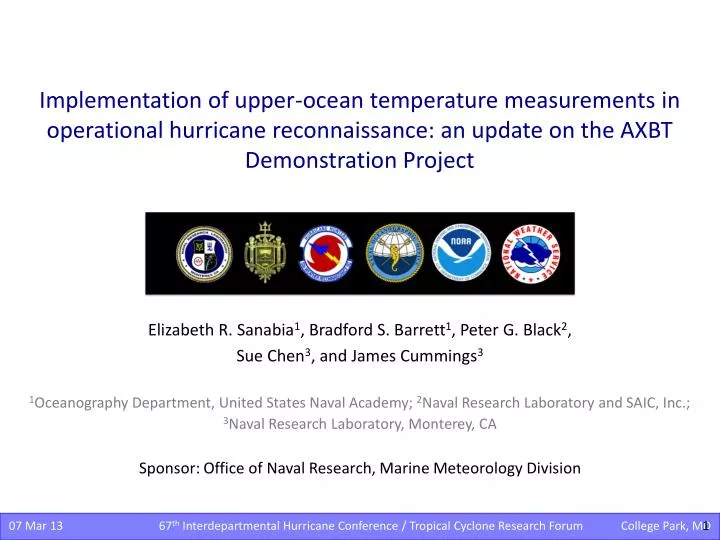
Implementation of upper-ocean temperature measurements in operational hurricane reconnaissance: an update on the AXBT Demonstration Project. Elizabeth R. Sanabia 1 , Bradford S. Barrett 1 , Peter G. Black 2 , Sue Chen 3 , and James Cummings 3.

E N D
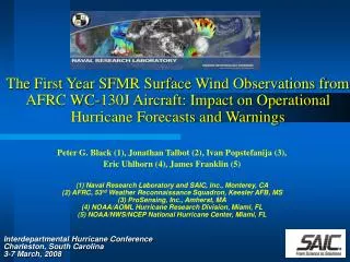
Implementation of upper-ocean temperature measurements in operational hurricane reconnaissance: an update on the AXBT Demonstration Project Elizabeth R. Sanabia1, Bradford S. Barrett1, Peter G. Black2, Sue Chen3, and James Cummings3 1Oceanography Department, United States Naval Academy; 2Naval Research Laboratory and SAIC, Inc.; 3Naval Research Laboratory, Monterey, CA Sponsor:Office of Naval Research, Marine Meteorology Division 1 • 07 Mar 13 67th Interdepartmental Hurricane Conference / Tropical Cyclone Research Forum College Park, MD
Quick Look & Outline 2012 • 31 July – 29 August • 294 AXBTs deployed • 23 flights • Training (1) • Hurricane Ernesto (8) • TS Helene (2) • Hurricane Isaac (12) 2011 • 28 July – 28 August • 109 AXBTs deployed • 12 flights • TS Don (2) • TS Emily (3) • Training /transit (2/1) • TS Harvey (1) • Hurricane Irene (3) Training 31 July 2012 Ernesto 3-9 August 2012 Helene 11,17 August 2012 Isaac 21-29 August 2012 • Today • Data Collection • Model Impacts • Ocean • Coupled • Statistical • Future Work 2 • 07 Mar 13 67th Interdepartmental Hurricane Conference / Tropical Cyclone Research Forum College Park, MD
Data Collection • Successes • AXBT deployment from WC-130J aircraft during operational reconnaissance missions tasked by the National Hurricane Center (NHC) • Real-time processing and data transmission to Navy and NOAA hurricane numerical forecast centers • Near-real-time assimilation of upper-ocean temperature observations into the COAMPS-TC model. • Challenges • Operational flight patterns • Data format • Position errors Mission Planning source: 2012_axbt_demo_proj_update_04aug12.docx 3 • 07 Mar 13 67th Interdepartmental Hurricane Conference / Tropical Cyclone Research Forum College Park, MD
WC-130J in flight • 2011 AXBT Data Path • AXBT Demonstration Project • Deploy Collect Process Transmit • 53rd SATCOM • Ground Station • NAVO • NRL MRY • National Hurricane Center • Disseminate • JJVV • RTDHS NCODA NCOM • COAMPS-TC REAL TIME • NCEP/EMC • NDBC • Upload • GTS • HWRF AXBT 06 JJVV Message AXBT 06 Profile JJVV 03081 0741/ 716360 069460 88888 51099 00291 00291 00291 14291 19289 57289 66287 72284 80278 99901 08270 30265 39261 56256 73242 83234 90228 93224 99902 00222 14216 33206 36202 51194 59190 69185 73183 80181 99903 15163 26162 36157 48154 56152 88140 99904 00138 06134 26133 42129 48126 65123 99905 04115 31108 48105 74099 99906 11092 65089 87084 99907 11080 97066 99908 48065 AF306 4 • 07 Mar 13 67th Interdepartmental Hurricane Conference / Tropical Cyclone Research Forum College Park, MD
WC-130J in flight • 2012 AXBT Data Path • AXBT Demonstration Project • Deploy Collect Process Transmit • 53rd SATCOM • Ground Station • NAVO • NRL MRY • National Hurricane Center • Disseminate • JJVV • COAMPS-TC REAL TIME • NCEP/EMC • NDBC • RTDHS NCODA NCOM • GTS • HWRF • Upload • Coupled Models (Research) • Other Research & Analysis • NRL MRY: COAMPS-TC • Disseminate • 1-m files • NAVO REAL TIME • NCEP EMC: HWRF • RSMAS • URI: GFDL • NOAA HRD / AOC POST-QC (Dec 2012) http://www.usna.edu/Oceanography/sanabia/tropic.htm 5 • 07 Mar 13 67th Interdepartmental Hurricane Conference / Tropical Cyclone Research Forum College Park, MD
2012 Field Phase Focal Points • Improve Data Quality • Spatial (and temporal) distribution • Minimize delays in transmission • Improve QC • Revised SOPs • Training by NAVO personnel • Portable bathy database onboard the aircraft • Ob Inter-comparison • CTD casts: UM R/V Walton Smith • Multiple sensors: NAVO • Increase Data Availability • URI • TROPIC web page • Tropical Atlantic Courtesy: Carl Szczechowski, NAVO 6 • 07 Mar 13 67th Interdepartmental Hurricane Conference / Tropical Cyclone Research Forum College Park, MD
Observation Inter-comparison All Profiles (glider, profiling floats, AXBTs) AXBT Profiles Map graphics: red x’s correspond to temperature-salinity profiles blue dots correspond to temperature-only profiles. Temperature profile graphics: gray profiles (background) correspond to all of the data in the area, blue profiles (foreground) correspond to the circled positions on the map graphics. Quality of AXBT profiles appears good; the AXBT profiles are consistent with the other profiles within the Gulf of Mexico. Courtesy: Carl Szczechowski, NAVO Cold Mode Profiles (all sources) Warm Mode Profiles (all sources) 7 • 07 Mar 13 67th Interdepartmental Hurricane Conference / Tropical Cyclone Research Forum College Park, MD
Impacts: Ocean Models • Successes: • Data denial studies revealed AXBT data increased model accuracy in upper-ocean temperatures at the AXBT drop locations in both NCOM and HYCOM (2011) • Adjoint analysis quantified significant value added by AXBT observations to HYCOM (2012) • Challenges: • Weighting the observation in the ocean models • Translating improvement in ocean initial conditions to coupled model TC forecasts EMILY IRENE 8 • 07 Mar 13 67th Interdepartmental Hurricane Conference / Tropical Cyclone Research Forum College Park, MD
2012: HYCOM AXBT Data Impacts Data map of AXBT impact to HYCOM 48-h sea temperature forecast between 24 August and 04 September 2012. A negative value (cool color) is a beneficial impact (reduced the 48 hr forecast error in deg C according to the color). A positive value (warm color) means assimilation of the AXBT increased forecast error. The region affected by position reporting errors is outlined in blue. 9 • 07 Mar 13 67th Interdepartmental Hurricane Conference / Tropical Cyclone Research Forum College Park, MD
AXBTs: High-Impact Observations Success: AXBTs were the most important data in reducing HYCOM model error during this time period. 10 • 07 Mar 13 67th Interdepartmental Hurricane Conference / Tropical Cyclone Research Forum College Park, MD
a 2011 COAMPS-TC AXBT Data Denial: Emily • EMILY • 1200 UTC 03 August 2011 • TC Forecast Track: some improvement • Track errors at 12, 18, 24, and 36 h were 10, 16, 9, and 84 km lower (relative improvement averaged 12.5%) • The track error at 6 h was unchanged, and the track error at 30 h was degraded by 40 km. • TC Forecast Intensity: little change • Little impact • May have shown little sensitivity to the inclusion of AXBT data because of the weak initial intensity of Emily (45 kt), compounded by an even weaker initialization in the model (only 25 kt the in COAMPS-TC initialization). b (a) Track and (b) intensity forecast errors for the COAMPS model run initialized at 1200 UTC 03 August 2011 with (blue diamonds) and without (red squares) AXBT data. The improvement (reduced error) or degradation (increased error) at each time step is noted above the x-axis in each plot. 11 • 07 Mar 13 67th Interdepartmental Hurricane Conference / Tropical Cyclone Research Forum College Park, MD
2011 COAMPS-TC AXBT Data Denial: Irene • IRENE • 0000 UTC 27 August 2011 • Little change in track and intensity errors • Possibly due to model initial TC position was located within the area with little SST/OHC difference • 1200 UTC 27 August 2011 • Some improvement to intensity at multiple time steps (<5 kts) when assimilating AXBTs • Little change in track errors 12 • 07 Mar 13 67th Interdepartmental Hurricane Conference / Tropical Cyclone Research Forum College Park, MD
AXBT Impact on TC Intensity in SHIPS • ERNESTO landfall • Differences in model and observed OHC impact SHIPS intensity forecasts • Intensity increments are calculated at each forecast time step applying SHIPS coefficients (courtesy M. DeMaria) to NCODA (model) and AXBT (observed) OHC values . • Range of model and observed OHC differences each day corresponds to range of model and observed intensity differences in the SHIPS forecast. • Provides a threshold of intensity variability at each time step (good agreement with the improvement in COAMPS-TC data denial studies). • Comparison to official forecast and best track intensities reveal some positive impact. • In 2013 • Incorporate Decay SHIPS • Investigate possible cooling in the model ahead of the TC center TOP: Hurricane Ernesto best track (purple line) and AXBT drop locations (shapes by flight) over NCODA OHC values (shaded) for 05 August 2012. BOTTOM: From right to left: Intensity (blue line) and OHC (red line) beneath the center of Hurricane Ernesto as the TC moved westward (positions based on NHC TC Report). Error bars indicate the range of differences between observed and model OHC values by flight. 13 • 07 Mar 13 67th Interdepartmental Hurricane Conference / Tropical Cyclone Research Forum College Park, MD 06 AUG 12
Summary • Successes • Demonstrated the capability • Deployed AXBTs from USAF WC-130J aircraft during operational missions • Received, processed, and QCd the data onboard the aircraft and transmitted to modeling centers • Data assimilated in two ocean models (NCOM and HYCOM) and one coupled model (COAMPS-TC) in real time • Improved model initializations and TC forecasts • Ocean: clear, quantifiable • Coupled: small improvements at later forecast hours • Statistical: impact evident; evaluation in progress • Joint, interagency collaboration • Remaining tasks • Demonstrate the need • Clear demonstration of forecast impacts • Coupled and statistical models • Optimize field phase operations • Sampling strategy (horizontal and vertical) • Improve timeliness and quality • Continue collaboration • Field phase – USAF, NAVO, NDBC, HRD/AOC • Research phase – NRL, EMC, URI 2012 TROPIC crew: Mary Cox, Ian Park, Ellen Deckinga, Kyle Coffey, Lauren McCann, TopherLeiby 14 • 07 Mar 13 67th Interdepartmental Hurricane Conference / Tropical Cyclone Research Forum College Park, MD
Future Work • 2013 Field Phase • 3rd year field phase: ~20 July – 20 September 2013 • Funded by ONR • Data Collection / Quality • Identify the optimal AXBT sampling strategy • resolution (horizontal & vertical), • location (relative to TC center), and • frequency for modeling initialization • Continue collaboration with NOAA HRD • Coordinate deployment planning (when feasible) • Increase observation accuracy and availability • Standardize data format • Investigate instrument error / biases • Variations due to fall rate • Temperature to frequency conversions • Horizontal displacement (atm / ocn) • Model Impacts • Run Coupled COAMPS-TC data denial studies • Continue NCODA/SHIPS OHC analysis • Continue collaboration with EMC/HWRF and URI/GFDL 2011 TROPIC crew: Ian Park & Elliot Hoy 15 • 07 Mar 13 67th Interdepartmental Hurricane Conference / Tropical Cyclone Research Forum College Park, MD