Download

1 / 25
250 likes | 351 Views
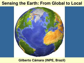
Remote Sensing of Earth and the Terrestrial Planets Guest Scientist: Dr. Chris Small. Earth2Class Workshop for Teachers Originally presented 26 Oct 2002. How can we observe objects we cannot reach?. We can use energy they emit or reflect. Everything in the Universe emits energy.

E N D
Remote Sensing of Earth and the Terrestrial PlanetsGuest Scientist:Dr. Chris Small Earth2Class Workshop for Teachers Originally presented 26 Oct 2002
How can we observe objects we cannot reach? We can use energy they emit or reflect. Everything in the Universe emits energy. When we use the appropriate instruments to detect those wavelengths, we can learn about the object.
“Passive” Sensing Most of the time, we use light, heat, or other wavelengths emitted or reflected by an object to detect our world. For instance, you are using your eyes to receive the light wavelengths emitted or reflected off the screen (depending on whether you are reading this on a computer or seeing the large screen presentation.) You are just “passively” receiving the energy.
“Passive” Sensing Satellites and spacecraft can detect energy emitted or reflected from Earth or other objects in the solar system in a similar way, if they are sensitive to the appropriate wavelengths.
“Active” Sensing Another way to detect the environment is to send out a signal and detect its “echo.” This is the basis for sonar and radar. Satellite- and spacecraft-based radar instruments have enabled us to learn much about our planet and our partners in the solar system, even when visible light is blocked by clouds or other phenomena.
Most familiar “remote sensing” views come from weather satellites http://www.goes.noaa.gov/browse.html
Examples of Observing Earth from Space Weather satellites, such as that shown here, capture visible, infrared, and other wavelengths emitted to space, then send their data back to Earth to be assembled into valuable images of our planet’s surface processes. http://noaasis.noaa.gov/NOAASIS/ml/genlsatl.html
Other Environmental Satellites Polar-orbiting satellites, such as the TIROS-N shown here, orbit the Earth at lower altitudes than weather satellites to provide much more detail about Earth processes. http://noaasis.noaa.gov/NOAASIS/ml/genlsatl.html
Observing Earth • NOAA’s National Environmental Satellite, Data, and Information Service (NESDIS) has primary responsibility for operating our nation’s weather satellites. • Military, commercial , and governmental agencies in the US and abroad also operate satellites for a variety of purposes, such as telecommunications.
USGS Remote Sensing The US Geological Survey utilizes a wide variety of satellites to observe resources and hazards on land. “Landsat” provided some of the first images more than 30 years ago. Today, much of this is done through the National Mapping Program. Their web site, http://mapping.usgs.gov/ , provide many valuable links about remote sensing for teachers and students.
Landsat The “Landsat” program is the longest-running program to observe Earth from space. Landsat 1 was launched in 1972. Landsat 7, launched in 1999, has added to the millions of remote-sensed images of our planet. http://landsat7.usgs.gov/index.php
Of course, long before and after satellite imaging, aerial photos provided interesting views of familiar objects from remote viewing locations. http://terraserver.homeadvisor.msn.com/
Even earlier, hot air balloons provided views from above that greatly changed the way in which we viewed our world. http://www.aeragon.com/03/03-28.html
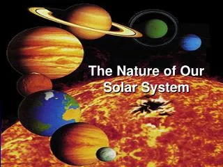
Remote Sensing in the Solar System Since prehistoric times, people have seen sunlight reflecting off other objects in the solar system Not really understanding the phenomena, they thought these were their deities, and so named them: Moon (Selena), Mercury, Venus, Mars, Jupiter, and Saturn
Galileo’s use of the telescopeprovided a new way to observe space http://www.th.physik.uni-frankfurt.de/~jr/gif/phys/stamp_galileo.jpg
Larger telescopes provided better views, but were limited by having to view outer space through Earth’s atmosphere Two images of Cal Tech’s Palomar Observatory http://www.astro.caltech.edu/observatories/palomar/images/p200.html
Rockets and satellites opened new “windows” on our solar system After the USSR launched Sputnik 1 in 1957, the USA followed with Explorer 1, the “Space Race” was on! Within a very short period of time, spacecraft were hurtling away from Earth toward the Moon, Sun, and planets! http://www.jpl.nasa.gov/missions/past/explorer.html
Pioneer 4 passed within 100,000 km (60,000 mi.) of the Moon in 1959 This spacecraft was the first US satellite to go near the Moon and then into solar orbit, where it remains today. http://www.jpl.nasa.gov/missions/past/pioneer.html
Over the past forty-plus years, many space missions have added to our knowledge—some by the data they sent back, some by their failures! NASA’s Jet Propulsion Laboratory has had primary responsibility for many of these missions. Their web site provides an excellent account of past, present, and future missions www.jpl.nasa.gov
Mariner 2 was the first spacecraft to explore another planet In August 1962, Mariner 2 made a 3-1/2 month trip to Venus. On the way, it measured the solar wind for the first time. Passing Venus, it detected the hot surface and cool clouds of what was then thought to be Earth’s “Sister Planet” http://www.jpl.nasa.gov/missions/past/mariner1-2.html
The Vikings Invade Mars In the mid-1970s, Viking 1 and Viking 2 landed on Mars and sent back exciting images of our next neighbor away from the Sun http://www.jpl.nasa.gov/missions/past/viking.html
Voyagers to the Outer Planets Shortly after the success of the Viking missions, NASA launched Voyager 1 and Voyager 2 on the “Grand Tour of the Outer Planets.” Their images of Jupiter, Saturn, Uranus, and Neptune, along with many new moons and rings, have forever changed our understanding of these remote planets. http://www.jpl.nasa.gov/missions/current/voyager.html
The discoveries continue … Today and into the future, NASA continues to explore our solar system and our home planet. For more information about: Current missions http://www.jpl.nasa.gov/missions/missions_index.cfm Future missions http://www.jpl.nasa.gov/missions/future_missions.cfm
On the drawing board… NASA even has proposed missions in the planning stages going out to 2015. These will explore such phenomena as “black holes in space,” “planetary chemistry and the possibilities for life,” and instruments capable of measuring wavelengths not possible to study now. We can’t imagine what such future explorations might reveal. http://www.jpl.nasa.gov/missions/proposed_missions.cfm
So, … • How does remote sensing “work”? • What have we learned through such remote sensing? • What can we do with such knowledge? These and much more will be discussed by today’s guest LDEO scientist, Dr. Christopher Small