Download
1 / 22
220 likes | 356 Views
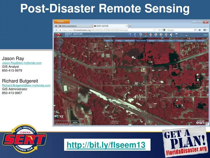
Post-Disaster Remote Sensing. Jason Ray Jason.Ray@em.myflorida.com GIS Analyst 850-413-9979 Richard Butgereit Richard.Butgereit@em.myflorida.com GIS Administrator 850-413-9907. http://bit.ly/flseem13. This presentation will summarize post-disaster remote sensing strategies –

E N D
Post-Disaster Remote Sensing Jason Ray Jason.Ray@em.myflorida.com GIS Analyst 850-413-9979 Richard Butgereit Richard.Butgereit@em.myflorida.com GIS Administrator 850-413-9907 http://bit.ly/flseem13
This presentation will summarize post-disaster remote sensing strategies – • State Emergency Response Team • Imagery acquisition • Imagery processing • Creating image service using ArcGIS Server Image Extension • Methods for display • Activities from Tropical Storm Debby (Summer 2012) will be reviewed http://bit.ly/flseem13
Florida Department of Transportation – Aerial Surveying & Mapping group is responsible for both Flight Operations and Photogrammetry. They develop statewide policies, procedures, and standards for aerial surveying products for the department and also acquire and process aerial photography. They support the District Offices in the production of planimetric and topographic mapping and create ortho-rectified and georeferenced imagery and digital terrain models (DTMs). The Aerial Surveying and Mapping group also provide critical support to the State Emergency Response Team by collecting aerial photography for disaster analysis and mapping. Professional Surveyors, Mappers, Photogrammetrists, and Pilots employed by the State. Requirements and capabilities coordinated through statewide GIS coordination call. Included are other State agency GIS Staff and Water Management Districts. Tasked as missions within EM Constellation. Aerial Photos http://bit.ly/flseem13
State of Florida – State of Florida uses a 5,000ft x 5,000ft orthophoto-LiDAR data acquisition grid agreed upon standard by FDOT, FDEP, FDEM, FWC, and the WMDs Grid available for download from SWFWMD Aerial Photos
Aerial Photos • Imagery delivered via hard drive to State EOC, as soon as possible after acquisition and with minimal processing… • Not true ortho-rectified images • Very little color balancing • Very little seaming or removal of overlap (white space) • TIF or SID • Following initial delivery, FDOT may follow up with additional deliveries of increasing image quality. http://bit.ly/flseem13
Imagery Processing Steps: • Transfer images from external hard drive • Imagery is stored on a network drive and on web server • On web server, start ArcMap… • Create new file geodatabase in Catalog • Create new Mosiac Dataset
Imagery Processing Steps (continued): • Add rasters – by workspace (directory) • Check radio buttons for Update Cell Size Ranges, Update Boundary, Build Raster Pyramids, & Calculate Statistics.
Imagery Processing Steps (continued): • Open ArcToolbox, Select Data Management Tools… • Under Raster Toolboox, select Mosaic Dataset Toolbox and then the Build Footprints tool...
Imagery Processing Steps (continued): • Set the Minimum Data Value to 0 & the Maximum Data Value to 250… • Pixel values – 0 (Black) to 255 (White). Setting your minimum to 0 & maximum to 250 will remove pixel values around the perimeter of the footprint greater the 250 or the white areas. • Set the Approximate number of vertices to 20. • Check Skip Overviews & Update Boundary then Click OK.
Imagery Processing Steps (continued): • Under Raster Toolbox, select Mosaic Dataset Toolbox and then the Build Overviews tool...
Imagery Processing Steps (continued): • To create an Image Service with processed imagery, right-click on Mosaic Dataset, & select Publish to ArcGIS Server... • Point to Web Server and provide a Service Name.
http://map.floridadisaster.org/GATOR Geospatial Assessment Tool for Operations and Response web based mapping application display real-time data like weather radar, watches, storm reports base maps, event, and post-event data GATOR http://bit.ly/flseem13
FloridaDisaster.org Geoportal http://floridadisaster.maps.arcgis.com/home/index.html http://bit.ly/flseem13
Any Questions? Jason Ray Jason.Ray@em.myflorida.com GIS Analyst 850-413-9979 http://bit.ly/flseem13