Download

1 / 21
210 likes | 337 Views
Integrated Web Environment for Walsaip Applications. Research Assistant Viky Arnedo Martinez Advisor. José A. Borges HCIG Graduate Student. Introduction What is GIS? Problem Formulation Previous Work Proposed Solution State of the Art Demo. Introduction.

E N D
Integrated Web Environment for Walsaip Applications Research Assistant Viky Arnedo Martinez Advisor. José A. Borges HCIG Graduate Student
Introduction • What is GIS? • Problem Formulation • Previous Work • Proposed Solution • State of the Art • Demo
Introduction This research is part of the Human-Computer Interaction group within the WALSAIP project. Our goal is to develop user interfaces and interaction paradigms that will facilitate the access and use of the complex applications and information managed by the project.
Introduction • What is GIS? • Problem Formulation • Previous Work • Proposed Solution • State of the Art • Demo
What is GIS? GIS : Geographic Information System. This is an integrated system composed of hardware, software, human resources, spatial information and computational procedures, that provides the collection, analysis and representation of spatial data.
Introduction • What is GIS? • Problem Formulation • Previous Work • Proposed Solution • State of the Art • Demo
Problem Formulation There are many powerful information management systems designed to manage, analyze, and manipulate complex data. However, many are not accessible to most users, are hard to learn and understand, and require multiple applications to analyze and represent results in an understandable manner.
Introduction • What is GIS? • Problem Formulation • Previous Work • Proposed Solution • State of the Art • Demo
Previous Work Puerto Rico Interactive – Geodata Ambient
Previous Work Puerto Rico Interactive – Geodata Topographic
Previous Work USGS – Water Watch
Previous Work Interfaces WebGIS
Introduction • What is GIS? • Problem Formulation • Previous Work • Proposed Solution • State of the Art • Demo
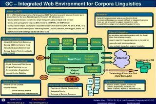
Proposed Solution Our goal is to develop user interfaces and interaction paradigms that will facilitate the access and use of the complex applications and information managed by the project. The proposed system will be able to provide access to GIS tools and GIS-based applications in a Web environment. The system will provide tools to access and manage multiple layers of information
Sensor #10 Humidity Pressure Proposed Solution
Proposed Solution Graphical User Interface
Introduction • What is GIS? • Problem Formulation • Previous Work • Proposed Solution • State of the Art • Demo
State of the Art Programming Language • Java (Jsp-Servlets-Beans) • Ajax (Asynchronous Javascript and XML) • SQL (Language Query Structure) Programs • Arc GIS • Rational IBM • MySQL
Introduction • What is GIS? • Problem Formulation • Previous Work • Proposed Solution • State of the Art • Demo
Demo At completion, We will be able to explain each of the tools required and define the procedure necessary to be able to have a Web browser that will communicate with GIS.