Download
1 / 9
90 likes | 234 Views
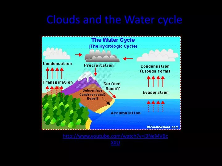
Clouds and the Water cycle. http:// www.youtube.com / watch?v =i3NeMVBcXXU. Evaporation: Evaporation is when the sun heats up water in rivers or lakes or the ocean and turns it into vapor or steam. The water vapor or steam leaves the river, lake or ocean and goes into the air. Transpiration:

E N D
Clouds and the Water cycle http://www.youtube.com/watch?v=i3NeMVBcXXU
Evaporation: Evaporation is when the sun heats up water in rivers or lakes or the ocean and turns it into vapor or steam. The water vapor or steam leaves the river, lake or ocean and goes into the air. Transpiration: Transpiration is the process by which plants lose water out of their leaves. Transpiration gives evaporation a bit of a hand in getting the water vapor back up into the air. Condensation: Water vapor in the air gets cold and changes back into liquid, forming clouds. This is called condensation. Precipitation: Precipitation occurs when so much water has condensed that the air cannot hold it anymore. The clouds get heavy and water falls back to the earth in the form of rain, hail, sleet or snow. Collection: When water falls back to earth as precipitation, it may fall back in the oceans, lakes or rivers or it may end up on land. When it ends up on land, it will either soak into the earth and become part of the “ground water” that plants and animals use to drink or it may run over the soil and collect in the oceans, lakes or rivers where the cycle starts all over again.
How are clouds formed? All air contains water, but near the ground it is usually in the form of an invisible gas called water vapor. When warm air rises, it expands and cools. Cool air can't hold as much water vapor as warm air, so some of the vapor condenses onto tiny pieces of dust that are floating in the air and forms a tiny droplet around each dust particle. When billions of these droplets come together they become a visible cloud
Cumulus clouds are white, puffy clouds that look like pieces of floating cotton. Cumulus clouds are often called "fair-weather clouds". The base of each cloud is flat and the top of each cloud has rounded towers. When the top of the cumulus clouds resemble the head of a cauliflower, it is called cumulus congestus or towering cumulus. These clouds grow upward and they can develop into giant cumulonimbus clouds, which are thunderstorm clouds.
Cirrus clouds are the most common of the high clouds. They are composed of ice and are thin, wispy clouds blown in high winds into long streamers. Cirrus clouds are usually white and predict fair to pleasant weather. By watching the movement of cirrus clouds you can tell from which direction weather is approaching. When you see cirrus clouds, it usually indicates that a change in the weather will occur within 24 hours Stratocumulus clouds are low, puffy and gray. Most form in rows with blue sky visible in between them. Rain rarely occurs with stratocumulus clouds, however, they can turn into nimbostratus clouds. Stratus clouds are uniform grayish clouds that often cover the entire sky. They resemble fog that doesn't reach the ground. Light mist or drizzle sometimes falls out of these clouds.
Cirrostratus clouds are thin, sheetlike high clouds that often cover the entire sky. They are so thin that the sun and moon can be seen through them. Cirrostratus clouds usually come 12-24 hours before a rain or snow storm. Altocumulus clouds are mid level clouds that are made of water droplets and appear as gray puffy masses. They usually form in groups. If you see altocumulus clouds on a warm, sticky morning, be prepared to see thunderstorms late in the afternoon.
Cirrocumulus clouds appear as small, rounded white puffs that appear in long rows. The small ripples in the cirrocumulus clouds sometime resemble the scales of a fish. Cirrocumulus clouds are usually seen in the winter and indicate fair, but cold weather. In tropical regions, they may indicate an approaching hurricane. Cumulonimbus clouds are thunderstorm clouds. High winds can flatten the top of the cloud into an anvil-like shape. Cumulonimbus clouds are associated with heavy rain, snow, hail, lightning and even tornadoes. The anvil usually points in the direction the storm is moving.
Altostratus clouds are gray or blue-gray mid level clouds composed of ice crystals and water droplets. The clouds usually cover the entire sky. In the thinner areas of the clouds, the sun may be dimly visible as a round disk. Altostratus clouds often form ahead of storms with continuous rain or snow. Altostratus Clouds Nimbostratus clouds form a dark gray, wet looking cloudy layer associated with continuously falling rain or snow. They often produce precipitation that is usually light to moderate. Nimbostratus Clouds