Download
1 / 1
10 likes | 95 Views
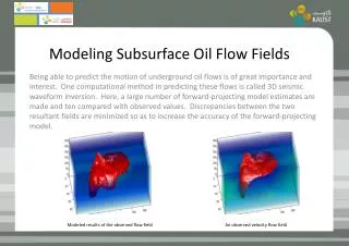
Modeling Subsurface Discharge Potential in Salmon Spawning Streams Western Washington University Jeremy Gilman. Diagram from Keller, E.A et al. Diagram from Keller, E.A et al. Background:

E N D
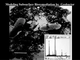
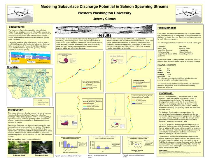
Modeling Subsurface Discharge Potential in Salmon Spawning Streams Western Washington University Jeremy Gilman Diagram from Keller, E.A et al. Diagram from Keller, E.A et al. Background: The movement of water throughout the hyporheic zone (Figure 1) has long been known to influence the survival and overall health of early life stage salmonids. The interaction of surface water and ground water within this zone creates a unique biogeochemical environment that salmonid species place their redds. It would be beneficial to the fisheries community to have a model that helped predict locations of subsurface discharge to the stream channel. These potential discharge zones could than be correlated to potential spawning habitat grounds for salmonid species. Field Methods: Each stream reach was habitat mapped for multiple parameters that have been defined to influence the potential for subsurface discharge to stream channels. Each habitat unit was evaluated for each of these parameters. The following parameters were measured for each habitat type: -Unit length -Unit slope -Valley slope -Channel Width -Underlying Geology -Habitat type -Mid-channel bar -Gravel Bar length -Large Woody Debris (LWD) -Secondary channel -Substrate For each parameter a ranking between 0 and 1 was issued to different types of that parameter based on relative importance. EXAMPLE: SUBSTRATE SILT 0.0 SAND 0.25 GRAVEL 0.50 COBBLE 0.75 BOULDER 1.00 The substrate ranking was established based on average porosity values for each substrate diameter. This technique was used for each parameter. All parameters were than weighted for relative importance to creating subsurface discharge. Results The two maps below represent Anderson and Thompson Creek respectively. Each identify areas of POTENTIAL SUBSURFACE DISCHARGE. These areas are ranked from low discharge potential to high discharge potential. A layer identifying suitable spawning habitat has been overlaid to show overall agreement between spawning habitat and subsurface discharge. The two maps below represent OVERALL SUBSURFACE DISCHARGE POTENTIAL at Anderson and Thompson Creek. The overall potential was developed by summing the rankings of all parameters and than dividing by the total number of parameters. OVERALL SUBSURFACE DISCHARGE POTENTIAL is ranked from low potential to high potential. Diagram by Prestagaard, M.L Site Map: Discussion: Much of the results found for both stream systems were based on a qualitative ranking of parameters known to influence subsurface discharge. The rankings were developed from past research that described parameter importance to developing subsurface discharge. These results are best used, exclusively, as a baseline for future analyses in correlating fish spawning habitat and subsurface discharge zones. The Anderson Creek results were suggestive of the underlying hypothesis that spawning habitat was strongly correlated to high subsurface discharge potential (see figure 1 in overall results). This agreement is due strongly to the greater abundance of overall spawning habitat found in Anderson Creek unlike Thompson Creek. The lack of agreement between spawning habitat and high subsurface discharge potential in Thompson Creek is most likely an artifact of little overall habitat suitability for spawning fish. This being said, the trend of greatest agreement being seen in higher potential zones is still observed in lower potentials (see figure 3 in overall results). This analysis is useful in that it can incorporate numerous physical parameters of a stream system and combine them with known spawning habitat. Most importantly, by using ArcGIS and route event analysis, these data can be changed to accommodate the morphological shifts of the channel that occur over time while retaining the original shape of the stream and associated data. References: Prestegaard, K. L., Bar resistance in gravel bed streams at bankfull stage, Water Resource Research., 19, 472-476, 1983. Keller, E. A., and F. J. Swanson, Effect of large organic material on channel form and fluvial process, Earch Surf. Processes, 4, 361-380, 1979. Whitaker, J. g., Modelling bed-load transport in steep mountain streams, in Erosion and Sedimentation in the Pacific Rim, edited by R. L. Beschta, T. Blinn, G. E. Grant, G. G. Ice, and F. J. Swanson, IAHS Publ. 165, 319-332, 1987. Wiberg, P. L., and J. D. Smith, Velocity distribution and bed roughness in high-gradient streams, Water Resource Research., 27(5), 825-838, 1991. Introduction: This project attempts to develop a model that can rank stream habitat units (lowest to highest) for potential subsurface discharge. These discharge zones will than be overlayed by a layer distinguishing preferred spawning habitat for salmonid species. An association can than be made between the two variables of interest. Two creeks, Thompson and Anderson, were chosen for their geomorphological uniqueness from one another. Thompson Creek is a high elevation stream that is glacial fed. It sits in a narrow valley with a channel bottom composed mostly of glacial deposits. Anderson Creek, on the other hand, is a low-land stream composed of alluvial deposits, and has a well developed flooplain. Both are used by a variety of salmonid species. Photo by J.Gilman 2004 Photo by J.Gilman 2004 Anderson Creek Thompson Creek Figure 3. spawning habitat/potential length Figure 2. spawning habitat/total reach Figure 1. spawning habitat /potential length