1 / 25

Map Conventions

Map Conventions. Latitude and Longitude. Latitude and Longitude. Latitude and Longitude. Latitude and Longitude. Magnetic Declination. Magnetic Declination. Magnetic Declination. Migration of magnetic north pole. Magnetic Declination. Scale. Using Scale. Using Scale. Topographic Maps.

alta
Download Presentation

Map Conventions

An Image/Link below is provided (as is) to download presentation Download Policy: Content on the Website is provided to you AS IS for your information and personal use and may not be sold / licensed / shared on other websites without getting consent from its author. Content is provided to you AS IS for your information and personal use only. Download presentation by click this link. While downloading, if for some reason you are not able to download a presentation, the publisher may have deleted the file from their server. During download, if you can't get a presentation, the file might be deleted by the publisher.

E N D

Presentation Transcript


  1. Map Conventions

  2. Latitude and Longitude

  3. Latitude and Longitude

  4. Latitude and Longitude

  5. Latitude and Longitude

  6. Magnetic Declination

  7. Magnetic Declination

  8. Magnetic Declination Migration of magnetic north pole

  9. Magnetic Declination

  10. Scale

  11. Using Scale

  12. Using Scale

  13. Topographic Maps

  14. Topo Maps

  15. Topo Maps

  16. Topo Maps

  17. Topo Maps - Bathymetry

  18. Topo Maps

  19. Topo Maps

  20. Topo Maps and Contour Interval What is the contour interval?

  21. Topo Maps and Contour Interval

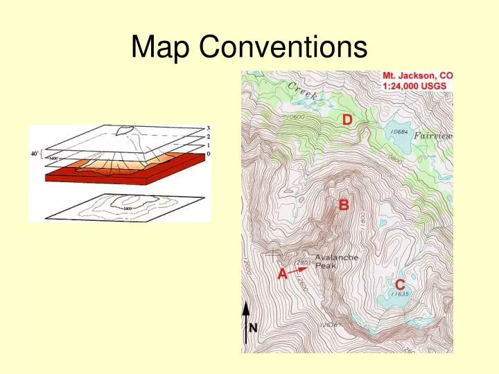
  22. Topo Maps and Gradient Note how gradient is reflected in spacing of contour lines. Close together = steep Far apart = minimal slope

  23. Topo Maps and Gradient Calculating gradient Rise over run 1,250 ft/5 miles

  24. Topo Maps and Streams

  25. Topo Maps and Depressions

More Related