Download
1 / 20
200 likes | 334 Views
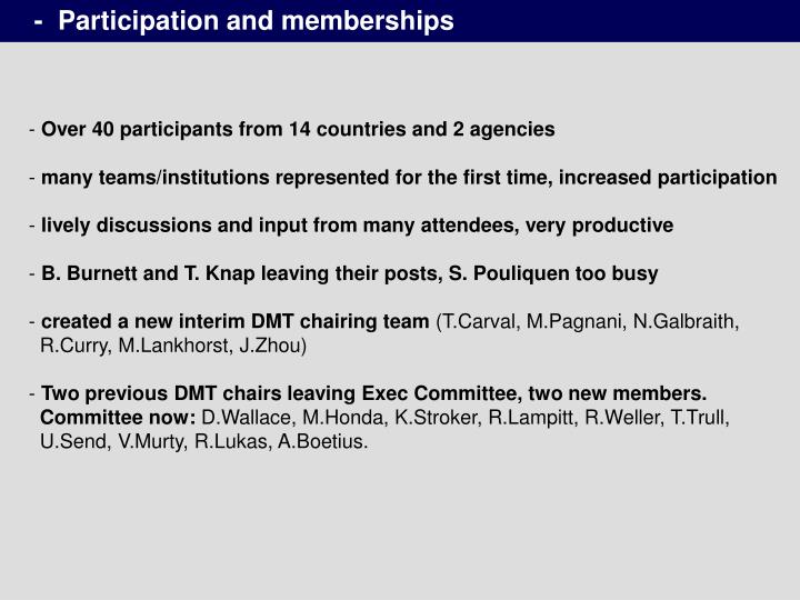
- Participation and memberships. Over 40 participants from 14 countries and 2 agencies many teams/institutions represented for the first time, increased participation lively discussions and input from many attendees, very productive

E N D
- Participation and memberships • Over 40 participants from 14 countries and 2 agencies • many teams/institutions represented for the first time, increased participation • lively discussions and input from many attendees, very productive • B. Burnett and T. Knap leaving their posts, S. Pouliquen too busy • created a new interim DMT chairing team (T.Carval, M.Pagnani, N.Galbraith, R.Curry, M.Lankhorst, J.Zhou) • Two previous DMT chairs leaving Exec Committee, two new members. Committee now: D.Wallace, M.Honda, K.Stroker, R.Lampitt, R.Weller, T.Trull, U.Send, V.Murty, R.Lukas, A.Boetius.
- Post-OceanObs09 framework • Frustration with slow growth in ocean climate observing system in last years before OceanObs09; at the conference new challenge/opportunity to grow and join with bgc and ecosystem community. • new framework for integrating the components, driven by requirements driving the process (observations, deployments, and maintenance) leading to output (data products creation). Societal issues lead to requirements, leading to essential ocean variables. The output/information should lead to impact on the issues (should check on that). • Examples of framework activities are: SST, OA and carbon, and zooplankton; OceanSITES can contribute to each. • Another outcome was the deep ocean observing strategy, initial definition was below 2000m. Challenge is to get physics, bgc, ecosystem together. Executive committee and writing team exists. Oceansites is very well poised and can/should insert itself into the framework for deep ocean observing. • What requirements drive OceanSITES, what are its unique data and information products, how is it connected with other elements of obs system to deliver on societal relevance. Try to take the product-focussed approach.
- Broadening ecosystem contributions • find provinces where point data gives useful information on some species • work with other communities to add spatial footprint to the timeseries, e.g. stock abundance needs ship surveys but with guidance and time information (need to know the space-time scales, timeseries can contribute) • make clear the contribution that fixed-point timeseries can deliver, work with the communities/teams that are developing ob system plans (e.g. workshop on operational biodiversity obs), and work with ship, glider, ocean tracking people • Decided to let the PI/operator define which ecosystem variables he wants to submit. If no format or variable names defined yet, request will be made to DMT to review this and decide whether it can be easily implemented • Roger Lukas will make an initial list of ecosystem variables from HOT which he wants to submit, and will work with Steve Diggs to make it happen. • Need to encourage BATS and CalCOFI to do the same.
- Value and purpose of OceanSITES • Until now OceanSITES provided a structure for collecting and disseminating existing stations, now need to take the next step • Now start designing the future network that closes gaps and addresses societal needs. • Provide reference stations, Keeling curves of the ocean, taking the pulse of the ocean, in representative provinces and in hotspots • provide calibration information for the distributed networks
- draft requirements for OceanSITES • Provide high temporal resolution (diurnal cycle) to directly observe processes/interactions and events (the “pulse”) • provide the long climate timescale to recognize slow global change (don’t even know whether productivity is increasing or decreasing…) • build a network (or networks according to discipline) that can be analyzed together (don’t even know whether productivity is increasing or decreasing…) • enable research/field work/process studies that build on background information from OceanSITES; assure re-use of the data and sites • contribute to requirements being defined by other groups, e.g. biodiversity framework
- Long term goals of OceanSITES • Secure long-term support for existing OceanSITES stations; • Upgrade stations with new sensors to record a host of physical, chemical and biological variables, enabling cross-discipline comparisons; • Install new stations in key regions of the globe to collect long-term records for the first time; • Rapidly distribute the data stream over the Web - for use by the OceanSITES team, the larger scientific community and the public; • Refine existing sensors and develop new ones to usher in continuous surface measurements in even the most brutal sea conditions.
- Metrics of network completion • OceanSITES has gone beyond the point where “more” is “better” • No single map or number for completion can be given since different parameters are measured at different sites, and each community will have different needs for a global network • Each discipline/community needs to develop the requirements for a global network, determine gaps, and argue with science how many sites are needed • state why N sites are needed to determine a quantity to within some error • OceanSITES will develop a set of targets/white papers/statistics of completion for each network (carbon, air-sea flux, ecosystem, circulation, Longhurst provinces, boundary current sites, throughflows, etc). • also work with IPCC to assess their need for timeseries for detecting global change, for testing/validation, and for fingerprinting • also need metrics that measure data delivery, data holdings, etc • metrics for users (who uses it for what, number of users, value generated, modellers) • Exec Committee was tasked to develop a set of recommendations
Products • for some products, integrate across platforms and disciplines, like SST products are generated by space, drifter, mooring, modelling, communities • decided to create a “products” directory on the GDACs, where PIs can provide processed or derived data (e.g. transports), or aggregated data (e.g. complete multi-deployment timeseries), with appropriate metadata (how generated, and reference to the original OceanSITES which have full metadata on the regular ftp directory) • other products are key/iconic results that would be presented on the website (and maybe on the “products” data directory). • Indicators are a type of product that capture a mode of ocean variability/change and that may have societal relevance and impacts on land. Those help to explain the need to sustain the observations. • often users from the public discover and develop their own use of timeseries that are provided (e.g. roofers in California look at altimetry maps of tropical Pacific). Provide simple views of data. • Decided to develop and provide products that make clear the value of timeseries and what is lost when they are discontinued.
- Path forward, including minimalistic backbone network • In times of scarce funding, need to take advantage of what is there already and build on it. So continue to include all sites that satisfy requirements but strive to use them to deliver strategic needs. • work towards opening all platforms to other OceanSITES members for adding sensors; this adds value to the sites, leverages support in both directions, and makes more people want to be part of OceanSITES.
- Minimalistic backbone network • homogeneous measurements would add value to OceanSITES since it enables network analyses • Goal is to provide a homogeneous subset of sites, that can contribute to the OceanObs09 requirement of merged physical, bgc, ecosystem obs system. • The previous draft plan should be revised to account for deep observations and (where reasonable/useful) Essential Ocean Variables. • The plan should be endorsed or modified by SOLAS and IMBER community, need their buy-in and participation/contribution; D.Wallace to take this to a/the (?) SOLAS workshop • reminder that this will not do everything that one might want, but the MINIMUM to address the multi-disciplinary needs • add those sensors that will provide needed timescales for the overall obs system • it’s 90% done, what does it take to add the last 10% ? Justify required additional funding in terms of needs – what additional questions could be answered ? • Existing operators can try to get funding for “missing” sensors, or different PIs get funding to add sensors to moorings of others (depends on agency, PI, etc).
- Minimalistic backbone network cont’d • Sensors need to come with the expertise for setup, calibration, processing, etc • Worth to push this in next 1-2 years since it gives a lot of impact for each $ spent, since platforms and cruises already there, and a lot of synergy/leveraging is generated. This is a low-hanging fruit. • Now invite other countries to participate, and work with GOOS Steering Committee (January ?) but don’t wait for their approval (we can get a head-start and set a precedent)
- “instant” contribution to deep ocean obs network • Ocean below 2000m has virtually no observing infrastructure – recognized gap and framework is being set up (meetings, writing team, etc) • OceanSITES has platforms in 100 places already that can make an immediate contribution and impact, by just adding 1 microcat near acoustic release. And a number of sites already have deep sensors. Can be in the water within 1 year. • Plan to set up a pool of donated microcats for matching those that PI voluntarily add. Chairs will draft a 1-page petition for donations from directors and POGO, agencies, foundations, etc. Can even offer a naming opportunity. • Challenge to add deep microcats at 50 sites, and match these with 50 more for swap-outs. Need to find 50 donations for matching pool, SIO director started with 3. • Have counter on website that shows status of pledges and donations to pool. • Instant pledges by PIs during the meeting amounted to 12 microcats, with 6 other participants promised to follow up with their institutions/PI’s. • Need to define need/requirement. • think about calibrations, maybe pool of instruments that rotate. Check with Seabird for in-kind donation of calibrations.
- OceanSITES website • the mission statement and purpose of OceanSITES must be front and center on the website • expand on “Pulse of the Ocean” theme, explain that we don’t know what’s happening in the ocean and that it matters • need to have a tool that allows PI, agencies, or users to check status of data holdings and delivery for each site • need clear explanation on Website of definition/requirement of an OceanSITES and of procedure how to join the network • maps need to have high visibility on the website, entry page needs to have one view • In Google KML files one can overlay many different data, model outputs, etc • Plots of anomalies and departures from long means is useful. • ARGO has a link for research users and the educational users (which then shows simple plots, which can be generated by the single projects but in a similar format). • show key examples from each site, maybe rotate them. • formed an action group for improving web site content
- Users • Earth system modellers want to have input on what is observed for them (Checkley). Would also address risk (impact) of losing sites • ocean modelling community • biogeochemical model intercomparison project OCMIP, D.Wallace will make contact • NWP community, including SURFA • IPCC
- New sites presented or updated • all MOC/MOCHA/RAPID sites, Florida Current cable transports, PIRATA NE extension (Lumpkin), South Atlantic SAMOC PIES • new Brazilian PIRATA sites • Korean site EC1 in East Sea (accepted into OceanSITES) • Indian sites: 7 equatorial moorings, 15 met buoys (met data can be shared), plus biogeochemical mooring (needs to check if data can be shared for sites outside EEZ) • French western Med network MOOSE, including a Gulf of Lion convection mooring • Australian IMOS eager to participate: Southern Ocean Timeseries (SOTS, 3 moorings incl sed trap), Indonesion Throughflow, East Australia Current, etc) • AWI Bremerhaven: Hausgarten (west of Spitsbergen) 3 moorings, Fram Strait 16 moorings, Weddell Sea moorings/PIES • Spain: 14 years of mooring timeseries in Lanzarote Channel, 1200m deep • Indonesian Throughflow and Weddell Sea sites by Lamont (A.Gordon) • FixO3 (EuroSITES follow-on) submitted, more sites than EuroSITES had • Drake Passage Array C-Drake (30-40 PIES) by Chereskin/Donohue • DART buoys may add deep microcats; explore option to include DART as platforms
JCOMM vs NOAA maps, NOAA nomenclature • JCOMMOPS needs to generate maps that are generated from the catalogue or database. Also some maps that show overall data holdings. • the NOAA sponsored OSMC shows only the realtime data status as judged by data on the GTS. For OceanSITES this gives a very biased view, since many sites are delayed-mode, many sites do not deliver data yet, some data are withheld from GTS, many data do not yet have a GTS format. • Need to have OSMC at least show a static map of the JCOMMOPS status for OceanSITES • Within NOAA and on NOAA maps/counting, OceanSITES appears as “reference stations”, but air-sea flux sites are separate “flux reference sites” and maybe even double-counted. This naming is confusing and does not show the OceanSITES brand. Work with NOAA to use the name OceanSITES.
- Definition of an OceanSITES, what should be included • Coastal carbon/OA mooring sites: CDIAC is a home for these sites/data, and IOOS may be in the US, and other countries will add CO2 to their nearshore moorings. OceanSITES does not want to dilute its efforts, in fact, it was decided to sharpen and re-focus more. What other reasons ? • Arrays of ship-occupied sites: Have to consider what makes OceanSITES unique and strong and desirable (to join) – it is the ability to cover all timescales, from very short to very long. Pulse of the ocean. If we have a sharp and crisp mission and vision, it will make it more compelling and of high standard, which builds the reputation. Decided NOT to include repeat ship stations per se. • Short and long timescales are both a requirement for OceanSITES (i.e. also no short mooring records). Sites in the system that do not currently satisfy both very well should aspire to do so. The long seasonal or monthly records at HOT, BATS, CalCOFI, line P, are important, and they provide historical perspective on new high-res data. So goal is to supplement/enhance these with autonomous data. HOT, CalCOFI, Line P have moorings, those sites should be in the system. BATS had moorings and should strive for that again. • Boundary current timeseries: Cable is already in OceanSITES. Action group appointed to consider which Eulerian data can be included, and what output • Decision not to host non-OceanSITES data in a separate directory.
- Data Holdings • currently 75 directories and 1200 files on the GDAC; but mainly physical data so far • large increase of submissions expected over next 6 months from new attendees • work under way to increase other variables, PIES data, etc • will follow up with PIs/operators more proactively when data are not delivered • delinquent sites will need to be removed from map or change status (turn black etc) • funding: all PI’s need to include funding for data management, including OceanSITES participation, in proposals.
- Future meetings • consensus was that joint face-to-face meetings of DMT and SC like this one work well. It makes it easier for those who need or want to attend both teams, and gives enough critical mass/weight/length to have stand-alone meetings without major conferences attached. • Needed approximately annually. This current meeting showed how much can be achieved by having people in a room. • Since no staggered 6-monthly events now, it is more important to keep momentum with virtual meetings. DMT and Exec will meet regularly via WebEx. Consider this also for occasional SC meetings ? • Tentatively accepted invitation by Kuh Kim for next meeting, probably early 2013.
- Funding for project office • need at least 60k$/yr • currently annually 30k$ from NOAA, 5k$ from Australia BOM, 5kEu announced from Ifremer • one-time POGO contribution of 5k, one-time SIO matching of 5K if someone follows, one-time year-end money from UK/NOC will be explored by Richard. • Norway research council may be willing to provide funding if their logo is on our website. Sven will investigate • Doug Wallace has some ideas for Canada contribution and will follow up • India is funding ARGO through Ministry – prepare a letter of request via IOC • Brazil will explore through Ministry of Science and Technology • Australia IMOS will check if ocean community can match the 5k from BOM • Lindstrom willing to find NASA way to support for CalVal and deep ocean network