Download
1 / 1
10 likes | 172 Views
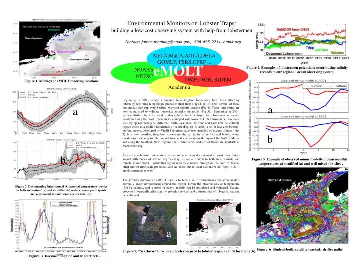
Environmental Monitors on Lobster Traps: building a low-cost observing system with help from lobstermen. Contact: james.manning@noaa.gov, 508-495-2211, emolt.org. MeLA,MaLA,AOLA,DELA GOMLF, FSRS,CFRF. eMOLT. NOAA's NEFSC. DMF, DMR, RIDEM.

E N D
Environmental Monitors on Lobster Traps:building a low-cost observing system with help from lobstermen Contact: james.manning@noaa.gov, 508-495-2211, emolt.org MeLA,MaLA,AOLA,DELA GOMLF, FSRS,CFRF ... eMOLT NOAA's NEFSC DMF, DMR, RIDEM ... Figure 4. Example of lobstermen potentially contributing salinity records to our regional ocean observing system. Academia Figure 1 Multi-year eMOLT mooring locations. a Beginning in 2000, nearly a hundred New England lobstermen have been attaching internally-recording temperature probes to their traps (Figs.1-3). In 2001, several of these individuals also deployed Seabird Microcat salinity sensors (Fig 4). These time series are now being used to validate numerical model simulations (Fig 5). Beginning in 2004, surface drifters built by local students, have been deployed by lobstermen at several locations along the coast. These units, equipped with low-cost GPS transmitters, have been used by approximately 50 different institutions since that time and have now collectively logged close to a million kilometers of ocean (Fig. 6). In 2008, a set of low-cost bottom-current meters, developed by Vitalii Sheremet, have been installed on dozens of traps (Fig. 7). It is now possible, therefore, to examine the variability of surface and bottom water conditions on hourly to inter-annual time scales at locations throughout the Gulf of Maine and along the Southern New England shelf. Time series and drifter tracks are available at www.emolt.org. Year-to-year bottom temperature variations have been documented at most sites. Inter-annual differences of several degrees (Fig. 2) are attributed to both local climate and remote source water. While this signal is fairly coherent throughout the Gulf of Maine, other shorter-time-scale processes such as those due to local tide and wind (Figs. 3 & 4) are documented as well. The primary purpose of eMOLT data is to feed a set of numerical circulation models currently under development around the region. Given the observations of temperature (Fig 5), salinity, and current velocity, models can be initialized and validated. Natural processes potentially affecting the growth, survival, and ultimate fate of lobster larvae can be addressed. a b b Figure 5. Example of observed minus modelled mean monthly temperatures at stratified (a) and well mixed (b) sites . Figure 2 Documenting inter-annual & seasonal temperature cycles in both well-mixed (a) and stratified (b) waters. Some participants are year-round (a) and some are seasonal (b). b a Figure. 6 Student-built, satellite-tracked, drifter paths. Figure 7. “SeaHorse” tilt-current meter secured to lobster traps (a) at 50 locations (b). Figure. 3 Documenting tide and wind effects.