Download
1 / 18
180 likes | 408 Views
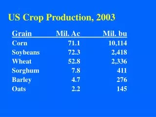
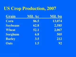
KENYA: Pilot - Crop Production Estimation. G. Galu GHA/USGS-FEWS NET. Objective. To develop an objective, reliable and timely procedure for estimating : Cropped area (CA) with potential for harvest, and utilimately maize crop production (CP). Methodology.

E N D
KENYA: Pilot - Crop Production Estimation G. Galu GHA/USGS-FEWS NET
Objective To develop an objective, reliable and timely procedure for estimating : Cropped area (CA) with potential for harvest, and utilimately maize crop production (CP)
Methodology Define a rainfed maize baseline map based on DRSRS/Africover / MoA/ LZ datasets. Validate WRSI performance vs. field observations (geo-referenced photos). Apply the crop mask on the fine-tuned WRSI products Delineate crop areas with potential for harvest based on WRSI values (set criteria??) and compute acreage. Compute statistical estimated yield based on WRSI/EoS and yield from MoA datasets. Compute estimated Crop Production (CP) from Yield (Y) and Acreage (CA) with potential for maize harvest.
Data-sets Ministry of Agriculture (MoA) statistics on cropped area, yield and production at district level (1997 – Present). ICIPE maize density maps derived from DRSRS aerial survey and photo-interpretation (1991-1997). FAO/Africover herbicuous crop maps based on DRSRS and Landsat image classification (2000). Livelihood zones baseline data on maize crop stats at sub-location level (updated 2005) WRSI fine-tuned and validated datasets for Kenya (LR: 1996- 2005) Geo-referenced digital photographs (July-August 2005).
DRSRS/ Maize Density maps FAO/Africover rainfed herbicuous crop Defining cropped area base-line map
Africover - rainfed herbicuous cropped areas vs. DRSRS maize density map Intercomparison between DRSRS vs. Africover Classes to broad • Generally, 2 maps comparable • Afriocover slightly more extensive
LZ data (mid/2005) Comparison with LZ data.. DRSRS + Africover/rainfed herbicuous maps Maize percent(%) coverage at Admin6 (6631 polygons)
Kenya and Tanzania: Crop Assessment Tour(mid/2005) Validate and fine-tune the WRSI model Ascertain the SoS and LGP baseline across key agricultural areas Determine uni- and bi-modal crop growing areas Understand maize crop growing conditions and practices Delineate bimodal Validate the DRSRS and Africover crop maps Develop a geo-referenced database of digital photographs to support current and future crop assessments
WRSI- crop performance: 1-10 Aug. 2005 WRSI: Average conditions Crop conditions vs. Geo-referenced photos WRSI: Failure conditions WRSI: Mediocre conditions
Trans-Nzoia Nakuru RFE vs. Raingauge Voi Makindu
Crop Acreage determination Adding LZ data for crop coverage Identification of areas with potential for harvest WRSI+Africover Geoprocessing WRSI Applying crop mask Spatial Joining Africover/herb crop
Merging WRSI and Crop (%) Coverage (Delieated crop areas From Africover) (WRSI with potential For harvest) = + • Criteria: 50% < WRSI <= 100% (??) • 0-50% : Assumed Crop Failure • 253%, 254% : Assumed crop failure
Crop Area Estimation: Africover, LZ data and MoA LZ estimates vs. MoA crop acreage r = 0.78 Y = 0.57(x) + 6060
Next Steps: Initial Estimates Yield based on WRSI(Long-rains 2005) Selection criteria: Large commercial farms (T/Nzoia, U/Gishu) Medium sized farms (Nakuru) Small farms and mixed farming (Kiambu) Flood prone areas (Nyando) Marginal agricultural areas (T/Taveta, Makueni, Kitui, Mwingi)
Data needs to cross-checked for some errors on average yield LZ Data: Maize Yield
Recommendations Crop assessment tours necessary in mid-year; maize crop tussling stage. Crop performance assessment (setting criteria to delineate failed crop) Fine-tuning WRSI with current maize crop varieties Monitoring changes on agricultural areas and updating cultivated maize percentages Re-run of WRSI locally with actual planting dates and improved RFE’s Use of geo-referenced digital photos on USGS/EDC web (Evidence…..Evidence…..Evidence)
Conclusion: Potential for a more objective crop production estimation with adequate lead time… Procedure easy to replicate in the region, in countries with fine-tuned WRSI model, validated Africover/herb. Crop maps and current livelihood maps. Additional benefits:Improve collaboration with MoA/extension officers. Changes in administrative boundaries will continue to pose serious challenges in this activity.