Download
1 / 23
260 likes | 649 Views
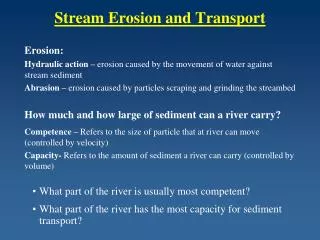
Stream Transport. Stream Load Erosion/Settling Velocity Importance Equilibrium / Rejuvenation Geomorphological Features. Stream Transport: Load. particle size. discharge. velocity. load. load. load. (This slide was introduced in The Dynamics of Moving Water )

E N D
Stream Transport Stream LoadErosion/Settling VelocityImportanceEquilibrium / RejuvenationGeomorphological Features
Stream Transport: Load particle size discharge velocity load load load (This slide was introduced inThe Dynamics of Moving Water) The ability of a stream to carry load of solid material varies with discharge, velocity and particle size. Question: Using these graphs, explain in words the relationship between discharge, velocity, particle size and load (the amount of material carried within the stream).
Stream Transport: Load • Solid matter carried by a river is called its STREAM LOAD. • A river’s ability to do work (pick and move material) depends upon its energy. • Stream Load can be carried in three different forms: • Dissolved load • Bed load • Suspended load • The varying dynamics of a rivers’ stream flow affect how these loads move. (velocity, discharge rate, depth etc.) • The geology of the underlying bedrock and surrounding geomorphology effect the amount of each of the above materials in a particular river.
Dissolved Load • The dissolved load is not usually visible; it is carried in solution. This is material carried in the form of dissolved ions resulting from mineral alteration. • 3.9 million tonnes annually are removed from the land in dissolved load. • Amount depends on rock type (bedrock) and climate.
Bed Load • Bed load is material that rolls, bounces, slides along the bottom of the river and is not supported by the water. • Sand, gravel and larger particles move along as bed load. • Moves slowly and it is hard to measure • The largest grain a stream can move by bed load is called its competence • A stream can move larger particles at times of flood • Capacity is the maximum amount of debris a given stream can carry as bed load • Depends on the stream gradient, discharge, and size of the load.
Suspended Load • Finer particles (clay and silt) are carried in suspension. Held within the water by turbulence and flow of the stream. • Once these particles are picked up, very little energy is needed to transport them, less than the energy needed to pick them up. • Highest concentration is near the bottom • Larger particles are near the bottom; smaller ones evenly distributed • Greater the stream discharge the greater the suspended load.
Critical Erosion Velocity • The lowest velocity at which grains of a given size will move. • The smaller the particles, the lower the velocity to move them. • Sand is easily eroded and carried; silt and clay size particles less so because the particles are “bound” or stuck together. • Gravel is hard to move simply because of its size. • The velocity at which grains are deposited • Varies according to grain size Settling Velocity
Importance • Knowing the load of a river is important for planning storage dams • Sediment trapped behind the dam will eventually fill it in and end the useful life of the reservoir • At the same time it deprives the river of sediment further down the river past the reservoir. This can upset the river’s regime • Eg., if the sediment load is reduced, when the same amount of water is put back into the river below the dam it can erode a lot more material, since the river is not carrying anything – this can scour the river bottom.
Importance • Knowing the load of a river is important when predicting the changes in river dynamics due to FLOODS. Floods increase the capacity of a stream to carry load (both suspended and bedload) because the volume of water flowing downstream increases. Floods are usually associated with increased velocity and this also increases a river’s capacity to move material. Eg., capacity to move bedload goes up about 3rd to 4th power of the velocity If a stream’s velocity is doubled in a flood, its capacity to carry bedload goes up 8 to 16 times, and the overall load will increase even more due to increased volume. Rivers, therefore, can change dramatically in floods.
Stream Equilibrium • A stage of river maturity, when down cutting is completed and there is a smoothly graded river course • In equilibrium the supply of load to a stream (from tributaries and from overland flow) equals the average rate of stream transport • In other words, capacity is satisfied by the load supplied. • The river cannot cut downwards without upsetting its equilibrium and therefore it tends to meander, cutting sideways at the banks. • As it erodes material from one bank (on the outside - Pool) it deposits material on the other bank (the inside - Riffle) and the load remains constant.
Stream Equilibrium: Rejuvenation • Rejuvenation: The stream equilibrium changes due to a change in the base level or increase in either the amount of water a stream carries or its load. • The re-establishment of a youthful stream when it starts to downcut. • Can occur in three ways: • Eustatic rejuvenation – caused by the lowering of the sea level during an ice age • Dynamic rejuvenation – caused by the uplift of the land during tectonic activity • Static rejuvenation – caused when either the load is reduced therefore increasing the capacity or when rainfall increases thereby increasing capacity.
More Geomorphological Features! • FLOODPLAINS • Valley area through which a river flows in the mature (old age) stage • Built by river depositing material on the insides of the bends as it meanders and when finer materials are deposited on the valley floor when the river floods. • Finer materials traditionally added nutrient value to the soil and thus helped to make floodplains very fertile areas, supporting large populations • Unfortunately, large floods also usually meant a loss of life as well. • A few floodplains support a large portion of the world’s population: Hwang Ho, Yangtze, Indus, Ganges and the Nile.
A Landsat 5 image taken Sept. 1992 shows a section of the Missouri River. The oblique perspective of this image is looking upstream. This image has been color enhanced and modified to show an exaggerated topographic relief. Bare soil and plowed land appears red, vegetation appears green, and water is dark blue. A flat river flood plain can be seen in the center of the image. Because of the season, most of the farmland located on the rich and fertile soils of the floodplain is plowed and devoid of vegetation. http://www.geog.ouc.bc.ca/physgeog/contents/11j.html
More Geomorphological Features! LEVEES Form on floodplains when rivers flood. Water quickly loses its velocity as it spreads out from the channel and deposition occurs Heavier sediments tend to settle out immediately close to the channel and an area of slightly higher ground is built up on both sides of the river Because of levees, the river channel is often built up higher than the floodplains, which is then very susceptible to flooding Yazoo streams are tributary streams that can’t reach the main river because of levees, and therefore flow parallel to the main channel in the river valley
Natural levees have been built up by man for flood control. http://www.spk.usace.army.mil/what/envir/fldpln/fldpln.html
Meanders and levees, Red River flood, Manitoba, 1997 http://sts.gsc.nrcan.gc.ca/page1/landf/smanitoba/levees.htm