Download
1 / 1
10 likes | 156 Views
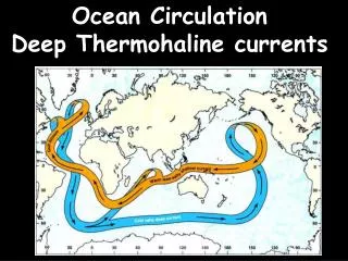
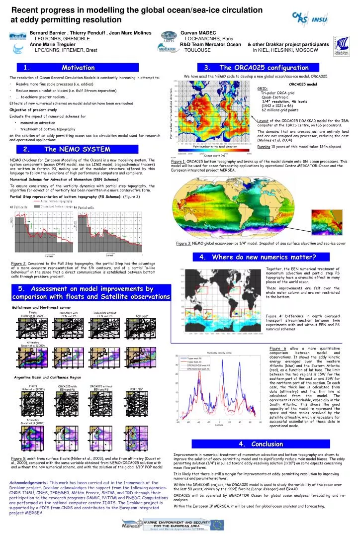
ORCA025 model GRID: Tri-polar ORCA grid Quasi-Isotropic 1/4° resolution, 46 levels (1442 x 1021 x 46) 62 millions grid points Layout of the ORCA025 DRAKKAR model for the IBM computer at the IDRIS centre, on 186 processors.

E N D
ORCA025 model GRID: Tri-polar ORCA grid Quasi-Isotropic 1/4° resolution, 46levels (1442 x 1021 x 46) 62 millions grid points Layout of the ORCA025 DRAKKAR model for the IBM computer at the IDRIS centre, on 186 processors. The domains that are crossed out are entirely land and are not assigned any processor, reducing the cost (Molines et al, 2004) Running 10 years of this model takes 124h elapsed. NEMO (Nucleus for European Modelling of the Ocean) is a new modelling system. The system components (ocean OPA9 model, sea-ice LIM2 model, biogeochemical tracers) are written in fortran 90, making use of the modular structure offered by this language to follow the evolutions of high performance computers and compilers. Numerical Scheme for Advection of Momentum (EEN Scheme): To ensure consistency of the vorticity dynamics with partial step topography, the algorithm for advection of vorticity has been rewritten in a more conservative form. Partial Step representation of bottom topography (PS Scheme):(Figure 2) Recent progress in modelling the global ocean/sea-ice circulation at eddy permitting resolution Bernard Barnier , Thierry Penduff , Jean Marc MolinesGurvan MADEC LEGI/CNRS, GRENOBLE LOCEAN/CNRS, Paris Anne Marie TreguierR&D Team Mercator Ocean & other Drakkar project participants LPO/CNRS, IFREMER, Brest TOULOUSE in KIEL, HELSINKI, MOSCOW 1. Motivation 3. The ORCA025 configuration We have used the NEMO code to develop a new global ocean/sea-ice model, ORCA025. • The resolution of Ocean General Circulation Models is constantly increasing in attempt to: • Resolve more fine scale processes (i.e. eddies) • Reduce mean circulation biases (i.e. Gulf Stream separation) • … to achieve greater realism … • Effects of new numerical schemes on model solution have been overlooked • Objective of present study • Evaluate the impact of numerical schemes for • momentum advection • treatment of bottom topography • on the solution of an eddy permitting ocean sea-ice circulation model used for research and operational applications. Point number in the meridional direction 2. The NEMO SYSTEM Point number in the zonal direction Ocean depth (m) Figure 1: ORCA025 bottom topography and broke up of the model domain onto 186 ocean processors. This model will be used for ocean forecasting applications by operational Centre MERCATOR-Ocean and the European integrated project MERSEA. Figure 3: NEMO global ocean/sea-ice 1/4° model. Snapshot of sea surface elevation and sea-ice cover 4. Where do new numerics matter? Figure 2: Compared to the Full Step topography, the partial Step has the advantage of a more accurate representation of the f/h contours, and of a partial “s-like behaviour” in the sense that a direct communication is established between bottom cells through pressure gradient. Together, the EEN numerical treatment of momentum advection and partial step PS topography have a dramatic effect in many places of the world ocean. These improvements are felt over the whole water column and are not restricted to the bottom. Figure 4: Difference in depth averaged transport streamfunction between twin experiments with and without EEN and PS numrical schemes 5. Assessment on model improvements by comparison with floats and Satellite observations Gulfstream and Northwest corner Floats Niiler et al (2003) ORCA025 without EEN and PS ORCA025 with EEN and PS POP 1/10° mssh mssh mssh mssh Altimetry Ducet et al (2000) Figure 6 allow a more quantitative comparison between model and observations. It shows the eddy kinetic energy averaged over the western Atlantic (blue) and the Eastern Atlantic (red), as a function of latitude. The limit between the two regions is 15W for the southern part of the section and 35W for the northern part of the section. In each case, the thick line is calculated from data (altimetry) and the thin line is calculated from the model. The agreement is remarkable, especially in the South Atlantic. This shows the good capacity of the model to represent the space and time scales resolved by the satellite altimetry, which is necessary for successful assimilation of these data in operational mode. eke eke eke eke Argentine Basin and Confluence Region Floats Niiler et al (2003) ORCA025 without EEN and PS ORCA025 with EEN and PS POP 1/10° mssh mssh mssh mssh Altimetry Ducet et al (2000) eke eke eke eke 4. Conclusion Improvements in numerical treatment of momentum advection and bottom topography are shown to improve the solution of eddy-permitting model and to significantly reduce main model biases. The eddy permitting solution (1/4°) is pulled toward eddy-resolving solution (1/10°) on some aspects concerning mean flow patterns. It is likely that there is still a margin for improvements at eddy-permitting resolution by improving numerics and parameterisations. Within the DRAKKAR project, the ORCA025 model is used to study the variability of the ocean over the last 50 years, driven by the CORE forcing (Large &Yeager) and ERA40. ORCA025 will be operated by MERCATOR Ocean for global ocean analyses, forecasting and re-analyses. Within the European IP MERSEA, it will be used for global ocean analyses and forecasting. Figure 5: mssh from surface floats (Niiler et al., 2003), and eke from altimetry (Ducet et al., 2000), compared with the same variable obtained from NEMO/ORCA025 solution with and without the new numerical scheme, and with the solution of the global 1/10° POP model. Acknowledgements: This work has been carried out in the framework of the Drakkar project. Drakkar acknowledges the support from the following agencies: CNRS-INSU, CNES, IFREMER, Météo-France, SHOM, and IRD through their participation to the research programs GMMC, PATOM and PNEDC. Computations are performed at the national computer centre IDRIS. The Drakkar project is supported by a PICS from CNRS and contributes to the European integrated project MERSEA.