Download
1 / 15
170 likes | 320 Views
Precision Agriculture: Past and Present. Justin Ludwig. Background. Biosystems and Agricultural Engineering (BAE) Junior Decided on BAE Okarche, OK Grew up on 1,300 acre wheat, cattle, and hay farm Up to 450 stocker steers in winter Alfalfa and Bermuda grass hay

E N D
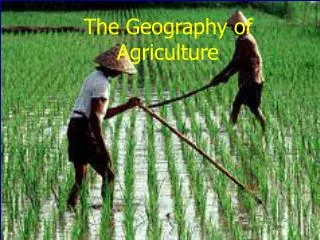
Precision Agriculture: Past and Present Justin Ludwig
Background • Biosystems and Agricultural Engineering (BAE) Junior • Decided on BAE • Okarche, OK • Grew up on 1,300 acre wheat, cattle, and hay farm • Up to 450 stocker steers in winter • Alfalfa and Bermuda grass hay • Been on the farm ever since age 3, cheap than a babysitter
Precision Agriculture in the 90’s • 3 technologies became widely availabile • Global Positioning System (GPS) • Geographic Information System (GIS) • Remote Sensing
GPS • Allowed farmers’ to find location in fields • Civilian got access in the 90’s • Started to produce yield maps in the late 90’s • Led to the light bar: http://www.trimble.com/agriculture/graphics/products/lb25.gif • Yield monitors • One of the first systems: • http://www.delmarlearning.com/companions/content/140188105X/trends/trends.asp
GPS Today • Accuracy for John Deere Starfire Receivers • WAAS Static Accuracy: 30 inches • WAAS Pass to Pass Accuracy: 18 inches • Starfire 1, exclusive to John Deere, Static Accuracy: 30 inches • Starfire 1 Pass to Pass Accuracy: 13 inches • Starfire 2 Static Accuracy: 10 inches • Starfire 2 Pass to Pass Accuracy: 4 inches • Starfire 2 is used for precise guidance applications
GPS Today • CNH Accuracy levels • AFS AccuGuideAutoguidance, AgGPSAutoPilot, AgGPSTrueTracker: 3 ft to sub in. depends on receiver • AgGPS EZ-Steer 500 Assisted Steering : 8 in. • AgGPS EZ-Guide 500: 3 ft to sub in, dependson receiver • AgGPS EZ-Guide Plus: 1 ft
GPS Today • AGCO Accuracy: • Submeter WAAS Static: 39 inches, Dynamic: 10 inches • SubmeterOmniSTAR VBS Static: 31 inches, Dynamic: 8 inches • Decimeter OmniSTAR HP Static: 4 inches, Dynamic: 2 inches • Decimeter Local Base DGPS Static: 4 inches, Dynamic: 2 inches • Centimeter Local Base RTK Static and Dynamic: .8 inches
Yield Monitors Today • Variety of monitors from John Deere, CNH, AGCO, Ag Leader, Trimble, and many others • Example of a Trimble Monitor: http://www.trimble.com/agriculture/yield-monitoring-and-mapping-capabilities.aspx?dtID=overview& • Ag Leader: http://www.agleader.com/products/yield-monitor/
GIS in the 90’s • Created in 1960’s, became popular in the 90’s • 4 phases in GIS history • 1st phase- Decided what was important. 1960-1975 • 2nd phase- Experimental use by national agencies. 1973-1980 • 3rd phase- Commerical use. 1982-Late 80’s • 4th phase- User phase 90’s-Present • Early 90’s- GIS released • Late 90’s- Adoption by cities and community organizations
GIS Today • Basis for Google and Bing Maps • Able to use rasters and vectors • Rasters-any digital image • Vectors- shapefiles made up of points, lines, and polygons
GIS Today Agricultural Use • Used to share data, increase data, increase yields, predict outcomes, improve business practices • Save expenses • Submit government program applications • Insurance crops, proving yields
Remote Sensing in the 90’s • Satellite imagery • Measure using the electromagnetic spectrum • Visible/Infrared Region • Infrared Region • Foundation of many sensors in use today • First models of many applications that have been improved • Grain bins sensor, Greenseeker, countless others
Remote Sensing Today • Used to apply variable rate fertilizers/pesticides • New and improved versions of older sensing applications • Soil sampling
Conclusions • Precision Agriculture has improved over the last 20 years, will continue to improve, cheapen • All help farmers • Reduce fatiage • Save money • Bring in new management practices