Download
1 / 30
300 likes | 529 Views
Asset Management Steering Committee. Quarterly Meeting December 14, 2009. Agenda. Welcome & Introductions Roles, Meetings & Communications Asset List – revamped Priorities & Work Plan development TransInfo Standards Signs & SAM-IT FACS-STIP Tool update Questions. AMSC Membership.

E N D
Asset ManagementSteering Committee Quarterly MeetingDecember 14, 2009
Agenda • Welcome & Introductions • Roles, Meetings & Communications • Asset List – revamped • Priorities & Work Plan development • TransInfo • Standards • Signs & SAM-IT • FACS-STIP Tool update • Questions
Meetings & Communications • Quarterly meetings • Second Monday? – March, June, Sept., Dec. • AMI developing for improved communications: • Web links for efficient sharing • “Circle” of interest to share proceedings more broadly • Other ideas?
AMSC Members’ Role • Serve as liaison • Leadership teams, committees, as well as division, branch, region or district • Look ODOT-wide for context • Communicate issues, opportunities, solutions • Advocate for principles of Asset Management efforts • Make decisions and recommendations for progress
AMI’s Role • Facilitate and coordinate availability of the: Right information Right people Right time
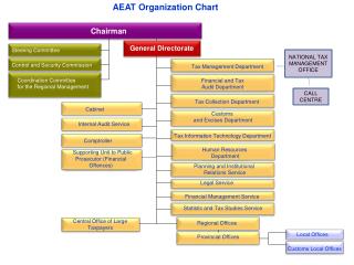
Relationships HLT Member ties to: PBLT PDLT MLT Reg. Mgrs. AMLT TLT CLT TOLT RLT BLT Geo/Env Freight AM & T-Data CSMT Audit Com. ISMT FSB TransCOI AMSC TransCOI Working Group AMI TS AM Task Force
Other Groups TS AM Task Force SAM-IT SAM Committee Scott King Randy Camp Pat Creedican Ramona Cline Mike Barry David Smith Dave Greenberg Joel Fry Dan Wells Sign Crew Reps Paul Wirfs Laura Wipper Bert Hartman John Coplantz Steve Lindland Harold Lasley Mike Kirby Harold Lasley Beth Sandver Galen McGill
Other Coordination Efforts • TransInfo Steering Committee • GIS-based tools (& Steering Committee) • Location standards & tools • Network Optimization Task Force • Engineering Data Management • Storm water drainage facilities • Freight Mobility/MCTD • Work Plan, readiness – systems projects & maintenance • Financial reporting requirements
Asset List – Proposed Draft Pg 1 of 3 Please see file: “AssetListV7”
Definitions • What is an Asset? • In financial terms, anything with • Expected useful life of one year or more • Original cost of $5000 or greater (OAM 15.60.10 PO section .103) • Costs for components as a system
Financial Reporting • FSB - for ODOT: • Prepares ODOT Financial Statement • Information included in State of Oregon report (Comprehensive Annual Financial Report or “CAFR”) • Financial Services staff created version of an asset management system • Procedures and processes to account for assets
Financial Reporting Challenges • Many folks involved in ODOT’s largest assets • Highways • Structures • Land • Current processes and systems fragmented across organizational structure • Compliance with reporting standards is a significant challenge
Asset Management & Financial Reporting • Asset Management efforts can provide means to comply with requirements • Financial reporting and accounting standards can provide structure for asset data • Effectively blended – sets the stage for much improved financial information
AMI Priorities - Draft • Sustain capacity gains already made • Support FACS-STIP Tool • 1R Roadside Inventories • Improve networks of input • Build decision processes • Build addition capacities • Establish/improve data cycles • Additional assets • Storm Water Facilities • Signs • Additional high profile attributes • Approaches • Vertical clearance
Priorities in Color Pg 1 of 3 Please see file: “AssetListV7-ColorCoded”
Key Principles for Progress • Collect data once for use by many • Instead of many times for one use • TransInfo will have key role • Location, location, location • Lynch-pin for integration (consistency = reliability) • Start with the basics - Basic inventory • Type, size, location & First Level Condition (c = r) • Readiness and capacity built in stages • Work plan
Work Plan • Progress based on readiness: • Definitions, resources & tools • Who, what, where, how and how much • Stakeholder input • Data plan – standards & storage • Experience with data • Field experience before inventory • Using data before system • Just guessing system requirements without it Please see file: “AMI-WorkPlanDetails”
TransInfo (Project to replace ITIS & Features Inventory) Update by Heather King Road Inventory & Classification Services Manager Please see file: “???”
Signs, Data Warehouse, etc. • Database officially transferred to Technical Services • Data quality reports run twice a month • SAM-IT had initial meeting • Follow-up quarterly face-to-face and as needed by phone • Need to set goals for data quality • Need to push resolutions for R4 & Cartegraph
SAM-IT Membership • Sign Asset Management-Implementation Team: • David Smith, R1 • Ramona Cline, R2 • Randy Camp, R3 • Pat Creedican, R4 • Mike Barry, R5 • Joel Fry, Maintenance & Operations • Scott King, AMI • Dave Greenberg, Tech Services • Dan Wells, IS
SAM-IT: Ensure sign data readiness to migrate to statewide system Approve recommendations Ensure resources for follow-through Develop requirements for TransInfo Sign Module SAM: Ensure sign data readiness to migrate to statewide system Prioritize issues Develop recommendations Review and comment on draft requirements for TransInfo Sign Module Role of SAM-IT vs. SAM Committee
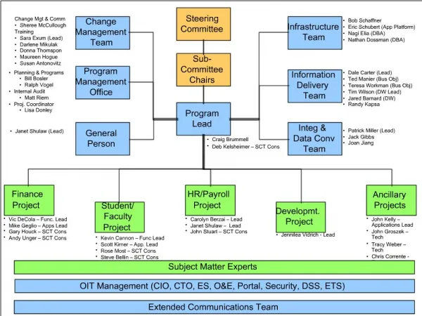
FACS-STIP Tool Origins of the Concept: • Circuit ride dialogues with regions • Accessibility of data a real issue The Concept (as of Spring 2009): • Move original tool to web • Expand data availability • Populate forms • Additional tables allow for appended data through phases (updated maps) • Mobility option - “data to go” • Regular e-mail notifications to asset owners will enable completion of data cycle
E-mail Notifications Regarding Changes (on some regular cycle) FACS/STIP Tool Concept Diagram Accessible Quantities of Additional Information Available for All Maps & Reports Change Reports Data To Go Arc Server Laptop Version Application Check-In/Check-Out Process Updates via the web New FACS/STIP Application Populated Electonic or Paper Forms Management System Desktop Version Management System Check-out Check-in Process Spatial Data Engine Data-Filled Forms Feature Manipulation Engine Management System Geo Database Corporate GIS Database Appended Additions & Changes New Additional Layers Misc.Files
FACS-STIP Tool To Date • Aggressive schedule! • June: Three WOCs delivered - Master project plan, desktop application moved to web, requirements for Asset Data To Go • July: Building Asset Data To Go • August: Building and beta testing with region staff • September: Compile and prioritize region comments • October: Application adjustments • November: Statewide training • Dec. 2009/Jan. 2010: Improvements and add’l data • Other Opportunities • 1R Program requirements (Roadside Inventory)
FACS-STIP Tool Data Decisions • Initial content based on: • Availability (and ability to integrate) • Priority based on input (region staff, asset owners • Other requirements (such as 1R) • Additional content based on: • Availability (and ability to integrate) • Priority based on continued input
Map Tool: Crash rates Bridge, Pavement & Safety project lists Bridge and culvert locations Traffic flow Traffic projections STIP 2008-2011 # Lanes; right & left shoulder Signed routes and road networks Regions and districts PLSS Counties and cities T/R/S (township/range/section, aka PLSS) Data to Go: ADA ramps Approaches Bike facilities Bridges Culverts Fish passage Pavement Retaining walls Safety – SPIS, SIP, crashes Sidewalks Traffic barriers Traffic support - signs Place to record special problems FACS-STIP Tool Data Currently available:
Map Tool: Aggregate sites Data to Go: Additional ADA ramp data Unstable slopes ITS sites Tunnels Weigh-in-Motion sites Traffic signals Auto traffic recorder sites FACS-STIP Tool Data Added availability Jan. 2010:
FACS-STIP Tool Enhancements Based on input: • Map option to select Area of Interest for Data to Go report (January 2010) • Improvements to Data to Go report format (January 2010) • Web version • Export to Excel • Add-asset comment function (June 2010?) • Using Map Tool with e-mail notification
QUESTIONS? DISCUSSION?