Download
1 / 1
20 likes | 128 Views
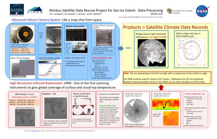
Nimbus Satellite Data Rescue Project for Sea Ice Extent: Data Processing G.G. Campbell 1 , M. Sandler 2 , J. Moses 3 , and D. Gallaher 1 IN53B-1627. Project supported by NASA #NNG08HZ07C subtask to NSIDC at the Univ. of Colorado. Advanced Vidicon Camera System : Like a snap shot from space.

E N D
Nimbus Satellite Data Rescue Project for Sea Ice Extent: Data ProcessingG.G. Campbell1, M. Sandler2, J. Moses3, and D. Gallaher1IN53B-1627 Project supported by NASA #NNG08HZ07C subtask to NSIDC at the Univ. of Colorado Advanced Vidicon Camera System: Like a snap shot from space. Name and quality control Products > Satellite Climate Data Records Navigate from time and orbit elements 1964 Ice Edge estimate vs 1970’s ESMR result Scan to make digital files. Merge many to get minimum reflectance > ice edge 9/1964 Meta data for each file: Time, Orbit # , Camera # and center location. Current navigation calculation is better than 1964 tick marks on film. AVCS 1960’s Archive = BW Film Entirely analog process Individual images will be saved in HDF format with navigation in the DAAC for general scientific use. 1964 Nimbus 1 5900 frames 1966 Nimbus 2 50000 frames 1969 Nimbus 3 20000 fr (bigger) Noise / Fiducial flagging Albedo = obs/cos(sun zenith) Calibration with gray wedge Archive product for users Raw scanned .TIF files HDF individual files Visible brightness Lat/Lon View angle, Sun angle NETCDF daily composites NETCDF weekly composites Mean brightness Minimum brightness Minimum “Albedo” NSIDC: NASA DAAC distribution Is the data good enough to justify bidirectional reflectance considerations? HRIR: We are attempting to find the ice edge with a comparison to the visible ice edge. The HRIR could be used for cloud or SST studies. Calibrations for SST are published. Studies of special weather events in the 1960’s are an other possible use of this data. Remap to EASE grid in NetCDF format High Resolution Infrared Radiometer: HRIR. One of the first scanning instruments to give global coverage of surface and cloud top temperature. HRIR Nimbus 1 to 4. Compute Considerations Merge Max Temperature Lead to SST or Sea Ice Archive product for users Merge Max Temperature Lead to SST or Sea Ice? Digital data recovery at GSFC HDF Swat data for each orbit Temperature from sat obs. Latitude Longitude View angle 1964 N1: ~300 TAP files ~200 orbits 1966 N2: 2457 TAP files ~2000 orb 1969 N3: 1116 TAP files ~1000 orb Dejitter + QC Data needs improvement The dejitter and remapping take considerable computer time. Amazon's Elastic Cloud Compute (EC2) Service was used to with simple bash scripts to turn what would be an over 3 months of processing on a single computer into a 3 day job for about $100. We will use this for further processing of Nimbus 1 and 3. NETCDF EASE grid remap of data for each orbit Temperature from sat obs. View angle August 1966 Max Temp. Nimbus2-HRIR-19660801_10-44-36_1041_001_GC_6.25km.nc NETCDF Weekly composites Limb darkening corrected Average T Max T Min T NSIDC: NASA DAAC distribution These mapped to EASE grid for north and south as well as global grids. Use a correlation with a smoothed image to calculate the cross track adjustments. Week 4 August 1966 Max Temp. Note geography of Antarctica G.G. Campbell: campbell@nsidc.org 1: NSIDC, U. or Colorado, Boulder CO., 2: Sky Corp, Mountain View, CA. 3: Goddard Space Flight Center, NASA, Greenbelt, MD.

![netCDF Operators [NCO]](https://cdn0.slideserve.com/623950/netcdf-operators-nco-dt.jpg)