Download

1 / 16
220 likes | 603 Views
Geographic Research Seminar Proposal. Jeremy Manny Georgia College and State University. Topic. The Spatial Relationship Between Air Traffic and Contrails in the U.S., 1980-2010 and Future. http://www.crystalinks.com/contrail607.jpg. Background.

E N D
Geographic Research Seminar Proposal Jeremy Manny Georgia College and State University
Topic The Spatial Relationship Between Air Traffic and Contrails in the U.S., 1980-2010 and Future. http://www.crystalinks.com/contrail607.jpg
Background The creation of contrails by air traffic patterns across the U.S. could map a link between contrails to climatic differences. The dependence on airplanes to get people from one part of the country to the other poses a problem to the areas below the heavily traveled air space. Solar heating of the surface could be hindered because of the contrails created by airplanes creating a surface cooling. Regions that experience climatic change in the slightest form could suffer from bad crop years if the region is agricultural and many plants could not handle the climate change.
Background Contrails reflect the incoming solar radiation away from the surface so that little solar radiation reaches the surface, but also traps outgoing radiation from the earth. The importance of looking at contrails over the land could show that regional heating is affected by clouds produced by airplanes and could cause a cooling and a heating on the surface that would affect the climate. Global warming could be sped up with the contrails being present and the outgoing radiation produced by the earth will be trapped. http://ww2010.atmos.uiuc.edu/guides/mtr/opt/mch/gifs/sct2.gif
Present Knowledge Contrails, which are short for condensation trails, are a type of cirrus cloud that are produced from the engine exhaust of airplanes. The particulates in the exhaust act as condensation nuclei that bond with water to form the clouds high up in the troposphere. These clouds are measured only when they “exceed a minimal optical depth of 0.02 and are not obscured by natural clouds” because otherwise, we would not know if they are there (Marquart 2003, 2892). Kuhn (1968) linked contrails with heavily airplane traffic areas were shown to have effects on the radiation that reaches the ground. There was a 12% decrease of incoming net radiation at the base of the contrail and a 7% decrease of radiation that reaches the ground (Changnon 1981). Kuhn calculated that if the contrails persist over an area for several hours then the surface temperature could drop 5.3°C (Changnon 1981).
Present Knowledge Climatic changes depend on the fraction of the area that is covered with contrails and the overall thickness they possess (Sausen 1998). Increases in persistent contrail cover could “affect the atmosphere’s energy budget and thermal regime” which could alter the amount of rain an area receives because of cloud development (Carleton 1986, 301). There is a program established to monitor and analyze contrails created by airplanes called Subsonic Assessment (SASS) and this analyzes “retrospective aerosol and contrail data analyses, modeling and laboratory simulations, extended time remote sensing measurements. SASS has also completed a study called Subsonic Aircraft: Contrail and Cloud Effects Special Study (SUCCESS) which used advanced aircraft and ground-based remote sensing measurements (Sassen 1997, 1886).
Present Knowledge The frequency of the occurrence of contrails and the fraction of the sky that they cover is being monitored by 19 stations in the contiguous United States (Sausen 1998). “Trends in regional cirrus frequency of occurrence are strongly correlated with high-altitude airplane fuel consumption between 1982 and 1991” and this shows an increase of airplane travel in those 11 years (Minnis 2004, 1672). “The global mean contrail cover was estimated to increase from 0.09% in 1992, to about 0.2% in 2015, and 0.5% in 2050, assuming a non-changing atmospheric environment” (Marquart 2003, 2890).
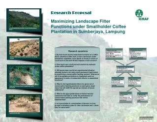
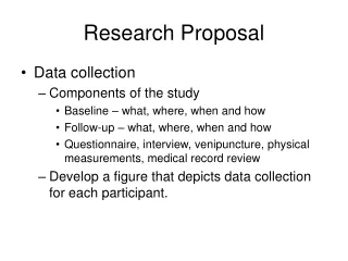
A Data (A). The national view of commercial and military fuel burned in pounds in May 1990 (Minnis 2003, 3448). (B). The overall contrail cloud coverage for the world in 1992 (Marquart 2003, 2893). Even though these are two different years, the contrail coverage and fuel burned are positively correlated. B
(A) Data (B) (C)
Data Figure A shows the differences of air travel and climate combined between 1992 and 2015 on the left and 1992 and 2050 on the right. In 2050, it shows the greatest increase in both climate and air travel. Figure B is the prediction of air travel based on the 1992 map shown previously. There is a extreme increase in air travel in the higher latitudes. Figure C is the climatic changes that are predicted to occur if the current trend of contrails persist. Note the higher latitudes. There is an increase as more and more contrails are created, the outgoing radiation will not be emitted back to space (Marquart 2003, 2893).
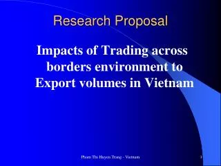
Data The annual mean contrail cover of persistent contrails (PC) which hang around for several hours (Minnis 2003, 3452). These areas could show a climate change based on the percentage of PC for the year.
(A) Data Methods that could be used to monitor contrails across the United States would be to have stations that monitor incoming solar radiation along with cloud coverage and a temperature gauge. These stations would be set up in areas where air traffic is heavy and contrails are persistent. I would also use satellite imagery (Figure A) and remote sensing to track the contrails across the United States (Carleton 1986, 302).
Expected Results I expect to be able to link climatic differences where persistent contrails are present from heavily air trafficked areas from the results of the methods that I want to employ. Graphs and charts will be used like the graphs shown in previous slides to map the areas with persistent contrails and climate differences.
Timeline and Budget This is a 2-year timeline in which I will be monitoring the stations that will be built and deployed in the areas that have persistent contrails and look at the satellite imagery of those areas of the cloud coverage. I am looking to receive $30,000 to begin buying the equipment necessary to monitor contrails and sufficient computers to analyze the cloud coverage and data that will be acquired through the stations. http://www.romcomm.com/images/WeatherSensors.jpg
Works Cited Carleton, A.M., and P.J. Lamb. 1986. Jet contrails and cirrus cloud: a feasibility study employing high-resolution satellite imagery. Bulletin of the American Meteorological Society. 67(3): 301-309. Changnon, S.A. 1981. Midwestern cloud, sunshine and temperature trends since 1901: possible evidence of jet contrail effects. Journal of Applied Meteorology. 20: 496- 508. Marquart, S., M. Ponater, F. Mager, and R. Sausen. 2003. Future development of contrail cover, optical depth, and radiative forcing: impacts of increasing air traffic and climate change. Journal of Climate. 16: 2890-2904.
Works Cited Minnis, P., J.K. Ayers, M.L. Nordeen, and S.P. Weaver. 2003. Contrail frequency over the United States from surface observations. Journal of Climate. 16: 3447-3462. Minnis, P., J.K. Ayers, R. Palikonda, and D. Phan. 2004. Contrails, cirrus trends, and climate. Journal of Climate. 17: 1671-1685. Sassen, K. 1997. Contrail-cirrus and their potential for regional climate change. Bulletin of the American Meteorological Society. 78(9): 1885-1903. Sausen, R., K. Gierens, M. Ponater, and U. Schumann. 1998. A diagnostic study of the global distribution of contrails part I: present day climate. Theoretical and Applied Climatology. 61: 127-141.