Download
1 / 13
130 likes | 265 Views
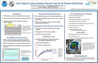
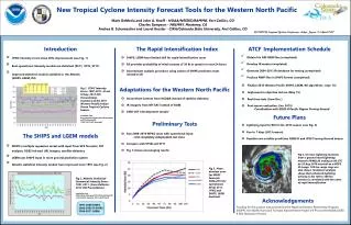
New Tropical Cyclone Intensity Forecast Tools for the Western North Pacific . Mark DeMaria and John Knaff NOAA/NESDIS/RAMMB Andrea Schumacher, CIRA/CSU. Operational Statistical-Dynamical Intensity Guidance Products . West Pacific ST10 – 5-day max wind forecasts

E N D
New Tropical Cyclone Intensity Forecast Tools for the Western North Pacific Mark DeMaria and John Knaff NOAA/NESDIS/RAMMB Andrea Schumacher, CIRA/CSU
Operational Statistical-Dynamical Intensity Guidance Products • West Pacific • ST10 – 5-day max wind forecasts • STIPS model with ensemble of tracks • Input from NOGAPS, NCODA ocean analyses • Atlantic/East Pacific • SHIPS – 5-day max wind forecasts • Input from GFS, Reynolds SST, OHC from satellite altimetry, GOES IR imagery • LGEM – Similar to SHIPS with more sophisticated prediction equation • Rapid Intensification Index – 24 hr Probability of V ≥ 30kt • Storm type classification algorithm • Tropical, Subtropical, Extra-tropical • Annular hurricane index – Identifies special class of symmetric storms
Experimental Statistical-Dynamical Atlantic/East Pacific Intensity Guidance • Improved Rapid Intensification Index • Version with lightning input (GOES-R3) • Being tested in GOES-R proving ground • Includes rapid weakening component • Version with total precipitable water, additional GOES data, surface flux predictors (JHT, GOES-R3) • Secondary eyewall formation index (JHT) • Estimates probability in next 12, 24, 36, 48 hr • SHIPS/LGEM Improvements (HFIP, JHT, GIMPAP) • Ensemble with forecasts and tracks from GFS, HWRF, GFDL, COAMPS-TC, additional global models • Adjoint version of LGEM for parameter fitting during forecast period and better use of pre-forecast input • Can run to 7 days or longer • Combining RII with LGEM to improve GOES utilization and RI forecasts
Models Being Transitioned to West Pac(NOPP, HFIP and Proving Ground Support) • Logistic Growth Equation Model (LGEM) • Lightning-based Rapid Intensification Index • Storm type classification algorithm • Testing to begin in 2nd half of 2011 typhoon season from CIRA
Logistic Growth Equation (LGE) Model dV/dt = V - (V/Vmpi)nV (A) (B) Term A: Growth term, related to shear, structure, etc Term B: Upper limit on growth as storm approaches its maximum potential intensity (Vmpi) LGEM Parameters: (t) Growth rate (from SHIPS parameters) MPI relaxation rate (constant) Vmpi(t)MPI (from SST) n “Steepness” parameter (constant) Input from GFS forecast, SST analyses, GOES, satellite altimetry Experimental versions with LEO TPW, lightning networks, satellite T,q retrievals
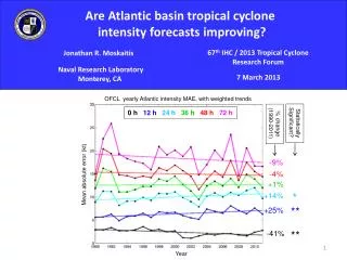
Operational Model Intensity ErrorsAtlantic 2007-2010 Operational Model Intensity Errors Atlantic 2007-2010
Modifications for West Pac LGEM and RII • 2001-2010 Developmental Sample • Replace GOES input with MT-SAT • Estimate maximum potential intensity from Bister and Emanuel (1998) instead of empirical formula • Improvement over Atlantic/East Pac version • OHC from NCODA fields instead of satellite altimetry retrievals
Experimental Forecast Algorithm:The Lightning-based Rapid Intensification Index (L-RII) • Linear discriminant analysis • Optimally weights multiple inputs to separate data sample into 3 classes • Rapid weakening, average intensity change, rapid intensification • NHC operational RII algorithm includes 8 inputs • GFS, Reynolds SST, GOES, satellite altimetry • Add 2 lightning parameters for L-RII • Inner core density (0-100 km) • Rainband density (200-00 km) • Versions with and without lightning from same developmental sample • Provides probability of RW, RI in the next 24 hr
2005-2010 Atlantic SampleLightning Density for RW, Avg, RI Cases
Storm Type Discriminators(Tropical, Subtropical, Extratropical) • From blended ocean products • SST • From GFS • 150 hPa T* • Vertical instability parameter * • 700-850 hPa T gradient from thermal wind eqn.* • r=500 km symmetric 500 hPa tangential wind • r=500 km symmetric 300 hPa tangential wind • 850-200 hPa shear • 0-500 km average 200 hPameridional wind • From NHC advisories • Northward component of translational velocity • Translational velocity magnitude • From GOES • 50-200 km %GOES pixels colder than -10oC • 0-30 km average GOES IR brightness T *Could be from JPSS ATMS/CrIS Retrievals
Summary and Future Plans • West Pac versions of LGEM, RII and Storm Type classification under development • Experimental real time runs from CIRA starting Sept 1st • Possible candidates for transition to JTWC through NRL • Improvements also possible from JPSS • Temperature/moisture soundings in storm environment from ATMS/CrIS • Input to Emanuel MPI to improve LGEM • Improved vertical instability predictors in LGEM, RII