Download
1 / 15
150 likes | 169 Views
Section 2: Fronts. Introduction. Section Objectives: Describe the formation of a front Differentiate among the formation of a warm front, cold front, stationary front, and occluded front Describe the weather patterns associated with each type of front. 4. Formation of Fronts.

E N D
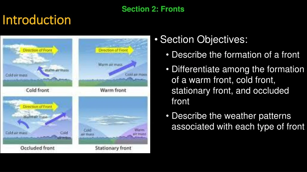
Section 2: Fronts Introduction • Section Objectives: • Describe the formation of a front • Differentiate among the formation of a warm front, cold front, stationary front, and occluded front • Describe the weather patterns associated with each type of front
4. Formation of Fronts • When two air masses with different properties meet, they form a front. • A front is a boundary between two contrasting air masses • Fronts are often associated with some form of precipitation • Most weather fronts are between 15 and 200 km wide • Above Earth’s surface, the surface of the front slopes at a low angle, so that warmer, less dense air overlies cooler, denser air
Formation of Fronts (cont.) • Occasionally, the air masses on both sides of a front move in the same direction and at the same speed • When this happens, the front acts simply as a barrier that travels with the air masses • In most cases, however, the distribution of pressure causes one air mass to move faster than the other • When this happens, one air mass advances into another, and some mixing of air occurs
5. Types of Fronts • Fronts are often classified according to temperature of the advancing front. • There are four types of fronts: • Warm fronts • Cold fronts • Stationary fronts • Occluded fronts
Types of Fronts (cont.) • Warm Fronts • A warm front is a front along which a warm air mass rises over a retreating mass of cold air • A warm front forms when warm air moves into an area formerly covered by cooler air • On a weather map, the surface position of a warm front is shown by a red line with red semicircles. • The semicircles point toward the cooler air mass • The slope of the warm front is very gradual • As warm air rises, it cools to produce clouds and frequent precipitation
Types of Fronts (cont.) • The first sign of the approaching warm front is the appearance of cirrus clouds • As the front comes closer, cirrus clouds change into cirrostratus clouds, which blend into denser sheets of altostratus clouds • About 300 km ahead of the front, thicker stratus and nimbostratus clouds appear, and rain or snow begins • Because of their slow movement and very low slope, warm fronts usually produce light to moderate precipitation over a large area for an extended period of time • A gradual increase in temperature occurs with the passage of a warm front • The increase is most apparent when a large temperature difference exists between adjacent air masses • In the Northern Hemisphere, a wind shift from east to southwest is associated with a warm front
Types of Fronts (cont.) • Cold Front • A cold front forms when cold, dense air moves into a region occupied by warmer air. • As this cold air moves it becomes steeper • On average, cold fronts are about twice as steep as warm fronts and advance more rapidly than warm fronts do • These two differences – rate of movement and steepness slope – account for the more violent weather associated with a cold front • On a weather map, the surface position of a cold front is shown by a blue line edged with blue triangles pointing toward the warmer air mass
Types of Fronts (cont.) • The forceful lifting of air along a cold front can lead to heavy rain and gusty winds • As a cold front approaches, cumulonimbus clouds often can be seen in the distance • Once the cold front has passed, temperatures will drop and wind shifts • The weather behind a cold front is dominated by a cold air mass • Weather clears soon after a cold front passes
Types of Fronts (cont.) • Stationary Front • When the surface position of the front does not move, a stationary front has formed • In a stationary front, two air masses come together but neither displaces the other • Gentle to moderate precipitation can occur • On a weather map, stationary fronts are shown by blue triangles on one side of the front and red semicircles on the other
Types of Fronts (cont.) • Occluded Fronts • When a cold front overtakes a warm front, an occluded front forms • On a weather map, an occluded front is shown by a purple line with triangles and semicircles • Develops as the advancing cold air wedges the worm front upward • Weather is generally complex • Most precipitation is associated with warm air being forced upward • When conditions are suitable, however, the newly formed front is capable of making light precipitation of its own
6. Middle-Latitude Cyclones • A middle-latitude cyclone is a large center of low pressure that generally travels from west to east and causes stormy weather • The air moves in a counterclockwise direction and toward the center of the low • Most have a cold front, and frequently a warm front extending from the central area • Forceful lifting of air causes the formation of clouds that drop abundant precipitation • How do cyclones form? • The first stage is the development of a stationary front • The front forms as two air masses move in opposite directions
Middle-Latitude Cyclones (cont.) • Over time, the front takes on a wave shape • The wave is usually hundreds of km long • As the wave develops, warm air moves towards Earth’s poles • There it invades the area formerly occupied by colder air • Meanwhile, cold air moves toward the equator • This change in airflow near the surface is accompanied by a change in pressure • The result is a counterclockwise airflow in the Northern Hemisphere
Middle-Latitude Cyclones (cont.) • Occlusion • Cold fronts move faster than warm fronts • When this occurs in the development of a middle-latitude cyclone, the cold front closes in and eventually lifts the warm front • This process, known as occlusion, forms an occluded front • As occlusion begins, the storm often gets stronger • Pressure at the storm’s center falls, and wind speeds increase • In the winter, heavy snowfalls and blizzard-like conditions are possible
Middle-Latitude Cyclones (cont.) • As more of the warm air is forced to rise, there are smaller differences in air pressure • In a day or two, the entire warm area is displaced • Only cold air surrounds the cyclone at low levels • The horizontal temperature difference is gone • At this point, the cyclone has exhausted its source of energy • Friction slows the airflow near the surface, and the once highly organized counterclockwise flow fades away
7. The Role of Airflow Aloft • In an anticyclone in the Northern Hemisphere, winds move in a clockwise direction. • Cyclones and anticyclones are generated by upper-level flow • Cyclones often exist for a week or longer • Surface convergence must be offset by outflow somewhere higher in the atmosphere. • As long as the spreading out of air high up is equal to or greater than the surface inflow, the low-pressure system can be sustained • More often than not, air high up in the atmosphere fuels a middle-latitude cyclone • The surface air that feeds a cyclone generally originates as air flowing out of an anticyclone


