Download
1 / 23
230 likes | 380 Views
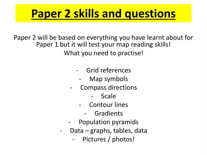
Paper 2 skills and questions. Paper 2 will be based on everything you have learnt about for Paper 1 but it will test your map reading skills! What you need to practise! Grid references Map symbols Compass directions Scale Contour lines Gradients Population pyramids

E N D
Paper 2 skills and questions Paper 2 will be based on everything you have learnt about for Paper 1 but it will test your map reading skills! What you need to practise! Grid references Map symbols Compass directions Scale Contour lines Gradients Population pyramids Data – graphs, tables, data Pictures / photos!
Grid references Rules: 1) ETNA – Eastings Then Northings Always! Along the corridor up the stairs! Always give the grid reference along the horizontal before the vertical 2) Always take the reference from the BOTTOM LEFT HAND CORNER of the grid! Northings Eastings
4 figure grid reference of a telephone near Ballynamallaght? A 48,99 B 4 figure grid reference of the peak at Balix Hill? C 47,96 4 figure grid reference for the peak of mount Cairn? 51,95
6 figure grid reference of the peak of Mount Cairn? 514, 952
Using a key On all maps it would be too difficult to label everything that is there and so a key must be used and understood in order to understand the map! These may show: types of buildings roads tourist facilities types of vegetation sports facilities
Compass directions There should always be a north arrow on the map you are using and this arrow always points to the top of your map! If there is not one you can always draw one on! You will need to know your directions using N,E,S,W as well as the smaller bearings in between e.g. NW, SW, NNE You can also use a protractor in order to give a bearing starting at 0º for North and always moving clockwise.
Scale Measuring a straight line Measuring a curved line 3) Length of the River from the footbridge 485,906 to the weir 531, 908. 1) Nyamwanga 43,91 to the Carse estate 41,84 2) Annadale 46,88 to Mycross 48,89
Homework – due Thursday Complete ALL of the following work: • Ganges Delta questions and case study • Flood management in an LEDC – Bangladesh • Waterfalls case study – do you need to redo it? • Boscastle MEDC flooding – is it good enough? • COMPLETE CLASSWORK!
Grid references and scale L/O: To be able to use 4 and 6 figure grid references, scale and keys to find locations on a map How would you measure a curved line on a map?
Scale All Ordnance survey maps usually have either a 1:50,000 scale or a 1:25,000 scale 1: 50,000, on this scale 2cm on the map = 1km on the ground 1: 25,000, on this scale 4cm on the map = 1km on the ground So you will measure the distance with a ruler on your map and then divide by the number of it by the number on your scale. E.G. 6cm on a map with a scale of 1:50,000 would be: 2 cm = 1 km 6÷2 = 3 Therefore it is 3 km in real life 10cm on a map with a scale of 1:50,000 would be: 2cm = 1km 10 ÷2 = 5 Therefore it is 5km in real life E.G. 10cm on a map with scale 1:25,000 would be: 4cm = 1 km 10÷4 = 2.5 Therefore the answer is 2.5km in real life
Contour lines and reliefL/o: To be able to use a map to explain the relief of an area Contour lines are lines on a map that show the elevation (height) of the land. On all modern maps the unit used to measure elevation is metres and the height of the land is always measured from sea level. Contour lines normally go up in regular increments e.g. 10 metres or 20 metres. You can use contour lines to understand the relief (shape) of the land and to recognise different geographical features. For example the closer the contour lines are, the steeper the slope (gradient) is. Also if you get a series of contour lines wrapping around in circles and increasing in height, then the feature is a hill.
Describing relief: Kedong, Kenya Plateau Gentle sloping hills Steep slopes Flat low lying land
https://www.youtube.com/watch?v=cB9wLUbEDkg Describing the relief on a map Contour lines and spot heights
Describing relief on a map - Kenya Convex slope Concave slope Uniform slope Hill Ridge Plateau Valley Saddle Spur Ridge Escarpment Use grid references and the key words to the right to describe: • The RELIEF on a map of Kenya HELP? - give grid references for the plateaus, valleys, flat plains, gentle AND steep slopes - describe the direction and the course of the river
Drawing relief graphs using contour lines In Geography we may be asked to draw a cross section of a hill or mountain to show us the relief. This means we will be showing what the land would look like from the ground if we cut the land across – hence the name cross section!
Relief and drainage Drainage – You are being asked about the rivers and water features of the area When asked to describe the drainage of a map area, the following points should be mentioned :-Density of surface drainage. This requires a description rather than a number.e.g. "There are many rivers in the north of the map but very few in the south" or"There are several large rivers with many tributaries".Relative width of rivers. i.e Are there streams? (shown on a 1:50,000 map by a single blue line), narrow rivers, wide rivers etc. Tidal or fresh water. Rivers are shown on an Ordnance Survey Map by an area of blue shading enclosed by two blue lines (fresh water) or black lines (tidal water).Relative speed of rivers. This can be judged by the number and closeness of the contour lines which a river crosses. Terms such as fast or slow flowing can be used to describe a river's speed.Describe the path of the rivers. i.e. Are they meandering, straight or a mixture of these two? Absolutely straight drainage on a map is usually artificial. i.e. usually for drainage in the United Kingdom. ReliefThe relief of a map refers to the shape of the land surface. When asked to describe the relief of a map, there are several things you should mention :- Main relief features Large scale features such as glaciated upland, dissected plateau or escarpment etc. (the area which you have to describe may only contain a small part of one of these features). Name any such feature (if present) and describe it if possible.e.g. "This map area forms part of a glaciated upland with many steep slopes".Now mention smaller scale relief features i.e. glaciated u - shaped valleys; spurs; ridges; knolls etc. Do not merely mention that these are present, you must state where they are (grid reference) and describe them.e.g. "The steep south west facing slope, which runs between squares 1847 and 2442, is dissected by several small river valleys".The third step is to apply some more detailed 'numerate' information (i.e. add some height numbers).e.g. state the range of altitude. This is very simple as all you have to do is mention the lowest and the highest points on the area of the map you are describing. You can get this information from contour lines, spot heights or trig points. It is important to give as accurate a height as possible e.g. :- Describe slopes on the map. To do this, verbally describe them using terms such as :-flat; gently sloping; fairly steep; steep; very steep; precipitous etc.
Gradients Vertical Interval (difference in height)Horizontal Equivalent (horizontal distance You may also have to calculate the gradient (steepness) of a piece of land. To do this you need to know the change in vertical height and horizontal distance. The first thing you need to do is make sure that both distances are in the same unit - this might involve you converting the horizontal distance from kilometres into metres (kilometres x 1000 = metres e.g. 0.5km X 1000 = 500m). Then look at how the height of the land changes between the TWO points given E.g. The first height is 900 m and it rises to 945 m. The difference is 45 metres You then divide the change in vertical height by the change in horizontal distance. e.g. 45m ÷ 500m = 0.09 If you want your gradient in a percentage you them multiply by 100 e.g. 0.09 (x100 = 9%)