Download
1 / 19
190 likes | 282 Views
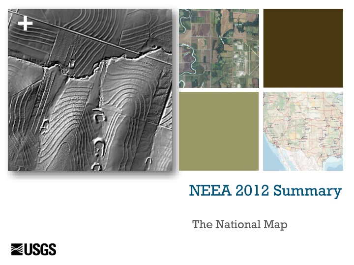
NEEA 2012 Summary. The National Map. National Digital Elevation Program (NDEP). Status of Elevation Data. 1996 - 2011 28% coverage - 49 states 15% coverage – Alaska 30+ year replacement cycle Program is efficient – less than 10% overlap of coverage Cooperative data projects work

E N D
NEEA 2012 Summary The National Map
National Digital Elevation Program (NDEP) Status of Elevation Data 1996 - 2011 • 28% coverage - 49 states • 15% coverage – Alaska • 30+ year replacement cycle • Program is efficient – less than 10% overlap of coverage • Cooperative data projects work • Data quality variable Why is this a problem? • Remaining 72% coverage is 30 or more years old. • Alaska – very poor quality • Meets 10% of need. Current and emerging needs require much higher quality data. • Map depicts public sources of LiDAR in all states plus IfSAR data in Alaska
National Enhanced Elevation Assessment Sponsor: National Digital Elevation Program (NDEP) – Twelve-member agencies, NSGIC Partners: U.S. Geological Survey (Managing Partner) National Geospatial-Intelligence Agency Federal Emergency Management Agency Natural Resources Conservation Service National Oceanic and Atmospheric Administration Study participants - 34 Federal agencies, 50 states and others Completed in December 2012
Business Uses (BU’s) • Natural resources conservation • Water supply and quality • River & stream resource management • Coastal zone management • Forest resources management • Rangeland management • Wildlife and habitat management • Agriculture and precision farming • Geologic resource assessment and hazard mitigation • Resource mining • Renewable energy resources • Oil and gas resources • Cultural resources preservation and management • Flood risk management • Sea Level rise and subsidence • Wildfire management, planning, and response • Homeland security, law enforcement, disaster response • Land navigation and safety • Marine navigation and safety • Aviation navigation and safety • Infrastructure and construction management • Urban and regional planning • Health and human services • Real estate, banking, mortgage, insurance • Education K-12 and beyond • Recreation • Telecommunications
Example Functional Activities (Needs) 602 Functional Activities documented from 34 Federal agencies, 50 States and Territories and from sampled non-profit, industry, local governments and tribes Precision Farming Land Navigation and Safety Geologic Resources and Hazards Mitigation Natural Resource Conservation Infrastructure Management Flood Risk Mitigation
Data Quality Level Choices Bathymetric LiDAR requirements assessed for three Quality Levels to include Low, Standard and High. Standard Quality Level (3-5 meter post spacing; RMSEz ~ 20 cm) Note – USGS LiDAR base acquisition specification version 13 is for QL3 data
Eight Candidate Program Scenarios 8-year scenarios 15-year scenarios 25-year scenario 8
Recommended Elevation Data Program Quality Level2 (QL2) LiDAR*- 8 year acquisition • Average Annual Costs: $146M • Average Annual Benefits: $690M (B/C Ratio - 4.7:1) • Total Possible Benefits Satisfied: 58% * Note: All scenarios include QL5 (IfSAR) for Alaska
Recommended Elevation Data Program QL2 LiDAR* - 8 year acquisition (3) • Advantages: • Achieves the majority of benefits • High benefit-cost ratio and net benefits • Benefits realized in 8 years instead of 30+ years for status quo • Meets all lower QL requirements and partially satisfies QL1 • Cost efficiencies achieved through large area acquisition strategy * Note: All scenarios include QL5 (IfSAR) for Alaska
Why QL2? Additional Considerations Upgrade path (buy up options) to QL1 more affordable to partners QL 3 data cannot be upgraded later, would need to be re-flown to meet needs for higher quality data Ecosystem services benefits were not quantified but usually require QL2 and better Emerging high value needs (ex. Land navigation) depend on QL2 Addresses growing trend toward higher resolution (GPSC)
Summary of Findings and Conclusions • Status quo program relatively efficient but meets less than 10% of measured needs. • All program scenarios provide favorable benefit cost ratios. • All program scenarios combine multiple requirements and collect data in large regular blocks to achieve improved cost efficiency. • IT infrastructure needed to manage data for all scenarios. • No technical barriers to moving ahead • Major dollar benefits are realized from high quality data.
Introducing 3DEP 3DEP is the name developed for the recommended program Purpose is to communicate that the program is more than bare earth elevation – the point cloud and other basic derivatives will be distributed and archived Tagline under development: 3DEP gives you the perspective to see more than just what’s on the surface 3D Elevation Program
Annual Benefits of 3DEP To Top Agencies
A Proposed 3DEP Funding Strategy Coalition of Federal agencies to commit funding annually to a national program. Top ten Federal agencies in rank order of benefits: NRCS, USACE, DISDI, USGS, NOAA, FEMA, EPA, USFS, FAA, and NGA States and other partner agencies will be invited to participate to provide balance of program cost Collection priorities will be based on coalition partner agency needs Partners may buy up to higher quality level (Quality Level 1) Acquisition cycle scales with funding Cooperatively Funded Program Executed by USGS
3DEP Development – Next Steps • Communications ongoing with potential partners and other stakeholders • Developing 3DEP branding materials • NGAC endorsement of program recommendation and strategic advice on funding strategy • Develop governance model for community review (June/July) • Flexible process to meet annual requirements of partner agencies • Use existing mechanism as the forum for negotiations: National Digital Elevation Program • Use lessons learned and model after successful partnerships, e.g., National Agriculture Imagery Program
Outreach Efforts Associate Director, Federal Agency Outreach USACE, DISDI, FEMA, FAA completed, five more planned Positive tone, agencies understand need for better elevation Agencies welcome opportunity to stretch limited dollars Agencies interested in model initiative language Annual planning cycle and project specific needs present a coordination challenge Active follow-up needed to advance funding opportunities Broader outreach strategy to States, select industries and associations under development.
NGAC, NSGIC Endorsements NGAC Recommendation: The NGAC endorses a national elevation program (i.e., 3D Elevation Program, or 3DEP) as described in the National Enhanced Elevation Assessment conducted by the U.S. Geological Survey (USGS). The NGAC encourages the USGS, the Department of the Interior, and Federal partner agencies to refine, adopt, and implement this program in partnership with other levels of government, academia, and the private sector. NSGIC: Letter of endorsement was sent to the USGS Director in April. Member states are supporting the recommended program and are asking that there be advanced planning and buy up opportunities.