Download
1 / 17
170 likes | 174 Views
The National Inventory and Monitoring Applications Center (NIMAC) develops advanced forest ecosystem inventory and monitoring methods and tools to ensure comparable results across landscapes. Focus areas include design and analysis toolkit, NFS and FIA data, and techniques research.

E N D
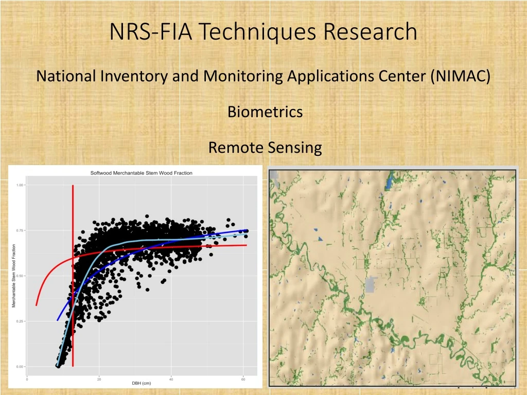
NRS-FIA Techniques Research National Inventory and Monitoring Applications Center (NIMAC) Biometrics Remote Sensing
National Inventory and Monitoring Applications Center (NIMAC) • Mission: To develop leading-edge forest ecosystem inventory and monitoring methods and tools to help FIA and other organizations monitor forests, resulting in comparable results across the landscape. • Three Primary Focus Areas • Design and Analysis Toolkit for Inventory and Monitoring (DATIM) • National Tool for NFS and FIA data • Joint NFS/FIA effort (funds and personnel) • Publicly available with ongoing development – Version 10.0 January 2019 Image source: Sjana Schanning Image source: pebbleshoo.com
2) I&M Technical AssistanceDomestic – various state forestry agencies, FWS, NFS, Tanana Chiefs (AK)International – 15+ Countries (primarily Central/South America, Africa)3) Techniques Research Sampling Statistical Modeling Remote Sensing
National FIA Volume/Biomass/Carbon Study • Cooperators/Technical assistance • University of Maine • Virginia Tech • Oregon State University • Michigan State University • University of Montana • University of Georgia • N. Arizona University • Industry: NCASI, Rayonier, Potlatch, Weyerhaeuser • Wood Properties: SRS RWU-4704, Forest Products Lab • Forest Management Service Center
National FIA Biomass Study Data • Over 3,000 felled trees – taper, biomass, C • Leverage existing FS, industrial, and university data to better capture spatial gradients in allometry and wood density. • Taper data • Biomass studies • Wood density measures • Publicly available at www. legacytreedata.org • Research accomplishments • 40+publications (mostly peer-reviewed journal) • 60+ presentations • Much of the foundational work has been done
National FIA Biomass Study Future • Continue development and evaluation of modeling framework(s) that meets FIA and clients needs. • Evaluate pro/cons and performance • Narrow the field of options • Pursue completion of biomass prediction system for national FIA implementation (~2020)
Urban FIA • Data and estimates for numerous cities becoming available in the next few years • Areas of research: • Precision of estimates – sample sizes • Evaluation of candidate geospatial layers for increasing precision and minimizing nonresponse bias for post-stratified estimators • Volume/Biomass/C (and components) models for urban trees • Estimation across rural-urban gradient (combining urban and rural forest inventory data) – paper in Forestry • Possibly other forestry concepts lacking an urban context • Diameter, Height growth models (Urban GRM) • Wood properties – specific gravity, ash content, etc. (w/FPL) • Crown size/shape models
Green Book II • Format • Foundation(hardcopy or online pdf) • Population and sample design • Estimation methods (inc. non-response, sample size, etc.) • Additional Information/Enhancements (internet repository) • Other relevant documentation • Alternative estimators if applicable (e.g., model assisted, small area/domain) • Models of key predicted variables if applicable (e.g., soil carbon) • Topic Areas (Contributors) • Introduction – including Green Book I overview and clarification (Westfall et al.) • National Woodland Owner Survey (Brett Butler) • Timber Products Output (John Coulston) • Urban FIA (Chris Edgar) • Land Use/Land Cover (Sean Healey) • Carbon (Grant Domke) • Ratio-to-Size estimation – (Chip Scott) • Alternative estimators – including small area estimation (Anderson, Moisen, Coulston, McRoberts, Patterson, Bell, Wilson, et al.)
Green Book II • Timeline • Status • Initial content nearly complete for Alternative Estimators • Wrapping up Intro material • Adding requested material (area estimation clarification, nonresponse, etc.) • Establishing review process (external)
Disturbance – combining panels East Texas – Lag effect in standing dead trees Hurricane Rita (2005) Hurricane Ike (2008) Drought (2011)
Disturbance – combining panels Single panel (SSP) and 3-panel (MSP) estimates provide better temporal resolution (but are less precise than full set (FSP) due to smaller sample size.
Forest fragmentation, urbanization, and landscape context geospatial data • Geospatial datasets currently available for 2020 State Forest Action Plans • Rachel can send a .ppt that outlines and illustrates all available data and summary analyses (rriemann@fs.fed.us) • Working with NA S&PF, FHM, WO and others to find the best way to make this geospatial data available after CloudVault expires. In the meantime we’re happy to send individually any data of interest. • Content for next round of comprehensive reports will additionally include: • change analyses (2000 – 2010 or 2016), and • analyses of several frag/urban/context metrics by ownership group and forest type group • Ongoing regional investigations into the relationships between forest characteristics and frag/urban/context measures across urban-rural gradients
Metrics and Geospatial data… • Fragmentation (changes in spatial distribution) • Spatial integrity index (patch size, local forest density, connectivity), • amount of edge • Urbanization (proximity to different types of urban development) • Wildland Urban intermix (based on house density), • human population density, house density/developed land, and relative rates of change in housing:population growth • Distance to roads • Landscape context (at several different scales) • Landscape pattern type, Local forest density, type of edge, local density of individual nonforest land cover types
Change, and analyses by forest type and owner groups • Change analyses (1990 – 2000 – 2010) • Change in percentage of forest in WUI • Change in intact forest 2001-2011 • Summary analysis of intact forest by owner group and forest type group (2001-2011). • Summary analysis of edge types by owner group and forest type group • By early to mid-2019, change in landscape metrics will be expanded to 2016, and include change in SII from 2001-2016 Intact Forest in 2011 by Owner Class Relative magnitudes of forest/nonforestedge type Proportion of forest in WUI since 1940, OH and surrounding states
Using Satellite Time Series Data at Specific Points to Remotely Monitor Change Jan July Jan July July Jan July Jan July Jan July Using Web Services, Submit a Latitude/Longitude coordinate and return graphs like the above. A computer algorithm identifies when the point appears to have changed. The shows where known change occurred, circle indicates something happened (lower NDVI threshold).
NASA CMS Program Participants – RGGI states for 2018-2020 • Canopy height maps (1m) and carbon maps (30m) using NAIP and LiDAR data • Maps and products made freely available • Goal is to provide tools for land managers seeking to account for carbon and land cover status and trends • FIA will determine how these products will help improve FIA processes. Examples include stratification, 3-D accounting of carbon, using as baseline for point-based land cover monitoring